
Technical data
- Difficulty
- Difficile
- Status
- aperta
- Distance
- 8,5 km
- Total duration
- 3 h 15 min
- Approach
- 1 h
- Ferrata time
- 1 h 30 min
- Elevation gain
- 170 m
- Max altitude
- 726 m
Route planning
How to plan Ferrata Badde Pentumas
Ferrata Badde Pentumas is in Monti Sardi, Nuoro, Italy and is rated Difficile. Available route data lists about 3 h 15 min total time, 8,5 km of distance, 170 m of elevation gain.
For day planning, consider an approach of about 60 min, about 90 min on the cable, a maximum altitude near 726 m.
The page includes a parking or driving-directions reference. A GPX track is available to review and download.
As with every via ferrata, evaluate season, lingering snow, storms, crowds and equipment condition. Page last updated on 7/4/2026.
Description
Overview
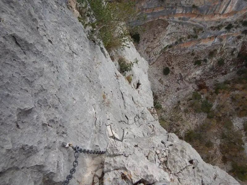
The Badde Pentumas Via Ferrata traverses the right side of the deep Badde Pentumas Canyon in Sardinia, following an airy route across a succession of ledges and slabs. The setting is dramatic, dominated by a rocky amphitheater of massive limestone, with vertical walls and imposing roofs defining its morphology. The route, recently revised and equipped with new gear, alternates between protected sections and short free-climbing passages during the approach, offering a continuous and engaging experience.
Approach
The starting point is in the Lanaittu Valley, in the province of Nuoro, near the Sa Oche Refuge. From Nuoro, reach Oliena and then Dorgali; following signs for Su Cologne, turn right. Just before the Su Cologne fountain, take a right onto a road that is initially paved, then becomes dirt, leading into the valley. Following it, pass the second large wooden sign for the refuge without turning, continuing straight toward Su Ruvagliu/Tiscali (trail marker 409B) for about 700 meters. On the right, a clearing with dark soil appears, bordered by two large boulders about ten meters apart, topped by a cairn; between the boulders, a tree bears a white and red trail marker. Park here.
Access to the via ferrata requires careful navigation, as it is not always well-marked. From the parking area, a wide forest path, dotted with cairns, descends in about 10 minutes toward a stream. It is crucial to spot an unmarked fork to the right, then follow some trail markers 410. The route continues uphill, but you must keep right while descending until reaching the streambed, often dry. Then, ascend the Pentumas Gorges for 30-45 minutes, overcoming rocks and short steps with free-climbing passages, up to a drop of about ten meters, now equipped with a fixed rope. After passing a first rocky amphitheater with a cave, you arrive at a second, more imposing one, characterized by large walls and roofs. A green inscription marks the start of the via ferrata, also recognizable by an old log and the first sections of rope. The approach takes about an hour from the parking area.
Via Ferrata
The equipped route begins with a vertical slab lacking metal fixtures, with a sandy base that makes using the cable advisable. This gains a first series of unprotected ledges, with passages up to first grade but already very exposed, requiring a steady foot and control. The pace is immediately challenging, alternating between short vertical sections and horizontal traverses on ledges. Next, another vertical slab passage is tackled, this time equipped with metal rungs, becoming pleasantly climbable after the first vertical meters. Reaching a dirt ledge, a short but demanding traverse to the left introduces an exposed connecting section along the ledges, where the route becomes more horizontal but no less airy.
The equipment resumes at a tree with a wedged stone. The route continues along a long equipped ledge, progressively narrower and more exposed, transforming into a traverse before widening. This sector is typically developed on ledges, offering a continuous and panoramic progression. The most adrenaline-fueled section begins with a large metal chain that allows traversing an exposed horizontal traverse to the left up to a dihedral. After a few vertical meters, a rather challenging overhang, aided by a rung, leads to a left traverse and an exposed edge to be rounded, one of the technically and physically most intense points.
A series of easier traverses, offering a rhythmic pause, precedes the vertical resumption of the cable on a beautiful and climbable section. Finally, a challenging dihedral is reached, with rungs mitigating its technical difficulty but not its great exposure. The final meters, more open, offer a panorama out of the amphitheater, concluding the via ferrata spectacularly. The climbing time is about 1 hour and 30 minutes from the start (2 hours and 15 minutes total from the parking area).
Descent
From the end of the Badde Pentumas Via Ferrata, climb completely up the wall to the summit, then descend to the right. A forest path, at a relaxed pace and downhill, leads back to the streambed traversed on the way in and, finally, to the refuge. The descent takes about 30 minutes, for a total of about 2 hours and 45 minutes from the start of the hike.
Useful Notes
The Badde Pentumas Via Ferrata does not present high technical difficulties in absolute terms, except in a couple of specific points. However, its character is distinctly horizontal and exposed: several traverses require decent arm strength for progression on the cables and an absolute lack of vertigo, especially in the initial unprotected sections. The route stands out for its exceptional scenic interest, unfolding entirely in a limestone canyon of rare beauty and visual continuity. The route is perfectly equipped after recent maintenance work, but the experience is predominantly panoramic and about continuous exposure rather than pure vertical difficulty.
Track and weather
Plan the route
Preview the GPX track from the backend, download it for your GPS device, open parking directions, and check a short forecast before leaving.
Images
FAQ
What level of commitment does this via ferrata require?
ferrata.faqAnswers.commitment
How much elevation gain should I plan for?
The listed ferrata elevation gain is 170 m. Also consider approach, return and maximum altitude, because they can matter more than the equipped section alone.
Where is the route located?
Ferrata Badde Pentumas is located in Monti Sardi, Nuoro, Italy. Before leaving, check parking, access and current local conditions.
When is the best time to climb it?
The best season depends on altitude, aspect and lingering snow. Avoid storms, wet rock and uncertain conditions; start early and keep a margin for the return.
Gear and safety planning
Use the technical data on this page to plan equipment, timing and offline navigation. For a general checklist, read the equipment guide before opening the route in the app.
Video
Watch the route
Useful YouTube videos for getting a real feel for the route before you go.
Logbook
Route condition reports
Recent community notes about closures, snow, equipment damage, trail issues and current conditions.
Community
Reviews, check-ins and photos
-
0 reviews
0
0 climbers
0
Shared by the community
Community photos
Recent images uploaded by Sferrati members.
No community photos yet
Open this route in the app to add the first photo.
Reviews
Recent impressions from climbers who know the route.
No reviews yet
Be the first to review this via ferrata from the app.
Continue in the app
Track the climb, save maps offline, and sync this route to your personal profile.
Use the app to climb
Offline maps, tracking, saves, and profile sync.
Scan the code before leaving, install the app, and keep your route data ready when reception fades.
