
Technical data
- Difficulty
- Moderatamente Difficile
- Status
- aperta
- Distance
- 13 km
- Total duration
- 7 h
- Approach
- 10 min
- Ferrata time
- 4 h
- Elevation gain
- 800 m
- Max altitude
- 2603 m
Route planning
How to plan Ferrata Bethaz Bovard
Ferrata Bethaz Bovard is in Alpi Graie, Aosta, Italy and is rated Moderatamente Difficile. Available route data lists about 7 h total time, 13 km of distance, 800 m of elevation gain.
For day planning, consider an approach of about 10 min, about 240 min on the cable, a maximum altitude near 2603 m. Reported route features include: Avvicinamento corto.
The page includes a parking or driving-directions reference. A GPX track is available to review and download.
As with every via ferrata, evaluate season, lingering snow, storms, crowds and equipment condition. Page last updated on 7/4/2026.
Features
Description
Overview
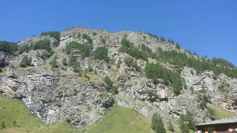
The Ferrata Bethaz Bovard, located in the municipality of Valgrisenche in the Aosta Valley, is a sweeping, ambitious route that rewards with a complete and intense experience. Its difficulty lies not so much in individual acrobatic technical passages, but in its considerable length, constant exposure, and accumulated elevation gain. The itinerary is structured into four distinct equipped sections, culminating in an airy, panoramic progression along a watershed ridge. The route develops on solid rock, typically granite or contact metamorphic, characteristic of the area's crystalline basement, offering generally excellent grip.
Approach
Access begins from the village of Valgrisenche, reachable via Regional Road 25. After parking your car in the town, head toward the imposing dam that dominates the head of the valley. Past the church, follow the paved road uphill toward a large former military building, now used as a warehouse. On the left side of this structure, the first rock steps equipped with steel cable are clearly visible, alongside the route's descriptive signboard. The approach from the town center is short, requiring about 10 minutes of walking.
Via Ferrata
The itinerary is conceived in four main equipped sections, each with its own escape route at its end. Progression is aided by generous use of metal stirrups, which define its predominantly vertical and continuous character, with few genuine resting spots.
- First Section: The start is gradual and immediately introduces the route's morphology. You ascend easy steps through sparse woodland, then tackle a vertical wall equipped with numerous stirrups. After a short traverse to the right, the climb continues leftward to a prominent ledge, which is skirted on its left side. Another vertical section allows you to gain height quickly. This is followed by a connecting trail and another traverse with stirrups, before overcoming a vertical wall that leads to a flat area next to a rockfall net. Here you encounter a wall with about three meters of overhang, a passage requiring attention when clipping your carabiner due to the exposure. The equipment temporarily ends; follow a marked trail, cross some boulders, and execute a traverse to the left. The sector concludes by tackling a slabby wall that ends beneath another overhang. This first block alternates short walks on wooded ledges with sustained climbing sections, setting an intense pace from the very start.
- Second Section: A uphill trail leads to the start. After an easy sloping wall, you face a long vertical slab with a continuous series of footholds. The route continues alternating between rocky steps, sloping walls, and short vertical pitches, with no major technical difficulties but maintaining constant physical effort. Another trail section through blueberry bushes precedes the last equipped stretch of this sector: a slightly overhanging wall, a traverse to the left, and a wall about seven meters high bring you to the end. Then follow the trail to the right on a slight descent heading north, walking it until the next start. This section unfolds on a more open slope, offering the first wide panoramic views of the valley below.
- Third Section: You ascend a non-steep wall to the left, then find yourself at the base of an imposing, exposed vertical wall. You climb it for several dozen meters using a dense sequence of stirrups, in a continuous, exposed progression that represents one of the most physically intense moments of the route. You then tackle some rocky steps and another vertical wall, shorter than the previous one. After completing this vertical section, you execute a traverse to the right, first horizontal then slightly descending, which concludes the third sector. The morphology here is more severe, with the via ferrata cutting into a compact wall, heightening the sense of exposure and altitude.
- Fourth Section and Final Ridge: A trail to the right leads to the last obvious wall. You begin with a slabby wall, then a vertical one in a dihedral. After overcoming several vertical and slabby walls, you enter an equipped ridge trail. This is the most airy and thrilling section of the entire Ferrata Bethaz Bovard, although it is not technically difficult. The progression unfolds literally along the ridge crest, overcoming boulders to climb, crevices to ascend, small dihedrals, and chimneys, all while enjoying a beautiful 360° panorama of Valgrisenche and the surrounding peaks. The pace becomes more varied and playful, despite the constant exposure on both sides. You thus arrive at the top of the last wall and the end of the via ferrata. The travel time from the start is about 4 hours (4h15' from the parking lot). A faint trail allows you to briefly climb to the nearby repeater for an even wider view. The final ridge represents the quintessence of the itinerary: a panoramic and balancing experience that crowns the effort of the previous vertical sections.
Descent
There are two main options for the return. The easiest and recommended itinerary involves continuing on a slight ascent along trail 18 to the Rifugio degli Angeli (2916 m). Behind it, climb to a col from which you descend (following trail 16) toward Arp Vieille. From here, take the military mule track (trail 17) that leads back to Valgrisenche. This route takes about 2 hours and 30 minutes from the end of the via ferrata, for a total of about 7 hours for the entire loop. Alternatively, you can cross a slippery scree field and, carefully orienting yourself in the absence of markers, intercept trail 18 to the right. This leads in about 2 hours to the village of La Bethaz. From the village, follow trail 22, parallel to the road to the right, which in just over 2 km returns to the starting parking lot.
Useful Notes
The Ferrata Bethaz Bovard is a challenging excursion due to its length, continuous exposure, and elevation gain, as well as the altitude at which it takes place. Although it does not have extreme technical difficulties, it should absolutely not be underestimated and requires excellent cardiovascular fitness and endurance for prolonged effort. It is essential to pay attention to the connecting sections and the return trail, where signage can be sparse or absent. Along the ridge, the equipment may temporarily stop: in that case, proceed by sight toward the repeater, where it will resume. At the start of the season, it is not uncommon to find sections covered with residual snow, so you must be equipped accordingly (ice axe and crampons may be necessary). Along the route, you encounter three escape routes: one at about 1930 m that connects to trail 17 for Valgrisenche; one at about 2200 m to the left, also linked to trail 17; and finally one at 2350 m that connects to trail 18 for La Bethaz. For the descent from the summit of Becca dell'Aouille, it is crucial to follow the yellow arrows that indicate traversing the upper part of the valley until trail no. 18. Descending immediately into the valley, ignoring the signs, leads to rock steps that make progression impossible. It is recommended to use detailed cartography, such as the 4Land map of the Gran Paradiso Group, and to carefully assess weather conditions given the route's total exposure.
Track and weather
Plan the route
Preview the GPX track from the backend, download it for your GPS device, open parking directions, and check a short forecast before leaving.
Images
FAQ
What level of commitment does this via ferrata require?
ferrata.faqAnswers.commitment
How much elevation gain should I plan for?
The listed ferrata elevation gain is 800 m. Also consider approach, return and maximum altitude, because they can matter more than the equipped section alone.
Where is the route located?
Ferrata Bethaz Bovard is located in Alpi Graie, Aosta, Italy. Before leaving, check parking, access and current local conditions.
When is the best time to climb it?
The best season depends on altitude, aspect and lingering snow. Avoid storms, wet rock and uncertain conditions; start early and keep a margin for the return.
Gear and safety planning
Use the technical data on this page to plan equipment, timing and offline navigation. For a general checklist, read the equipment guide before opening the route in the app.
Video
Watch the route
Useful YouTube videos for getting a real feel for the route before you go.
Logbook
Route condition reports
Recent community notes about closures, snow, equipment damage, trail issues and current conditions.
Community
Reviews, check-ins and photos
-
0 reviews
0
0 climbers
0
Shared by the community
Community photos
Recent images uploaded by Sferrati members.
No community photos yet
Open this route in the app to add the first photo.
Reviews
Recent impressions from climbers who know the route.
No reviews yet
Be the first to review this via ferrata from the app.
Continue in the app
Track the climb, save maps offline, and sync this route to your personal profile.
Use the app to climb
Offline maps, tracking, saves, and profile sync.
Scan the code before leaving, install the app, and keep your route data ready when reception fades.
