
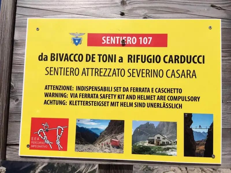
Ferrata Casara alla Croda dei Toni
Croda dei Toni · Bolzano · Italy
Technical data
- Difficulty
- Difficile
- Status
- aperta
- Distance
- 19 km
- Total duration
- 10 h
- Approach
- 3 h 30 min
- Ferrata time
- 3 h 30 min
- Elevation gain
- 260 m
- Max altitude
- 2556 m
Route planning
How to plan Ferrata Casara alla Croda dei Toni
Ferrata Casara alla Croda dei Toni is in Croda dei Toni, Bolzano, Italy and is rated Difficile. Available route data lists about 10 h total time, 19 km of distance, 260 m of elevation gain.
For day planning, consider an approach of about 210 min, about 210 min on the cable, a maximum altitude near 2556 m. Reported route features include: Ponti sospesi, Alta montagna, Itinerario lungo, Interesse Storico.
The page includes a parking or driving-directions reference. A GPX track is available to review and download.
As with every via ferrata, evaluate season, lingering snow, storms, crowds and equipment condition. Page last updated on 7/4/2026.
Features
Description
Overview
The Ferrata Severino Casara is a high-altitude route that traverses the Croda dei Toni massif (Cima Dodici) in the Sexten Dolomites. This link between the eastern and western flanks of the group offers a demanding experience, immersed in a severe, monumental-scale environment. The main difficulty lies in the length, cumulative elevation gain, and prolonged exposure, while the individual equipped passages do not reach extreme technical levels. This is a physically very challenging hike that requires careful assessment of conditions and excellent athletic preparation.
Approach
The recommended starting point is the parking lot at the Hotel Dolomitenhof in Val Fiscalina (1454 m), reachable from Sesto via Moso. The alternative access from Cadore (Auronzo) is currently not recommended due to the closure of the trail from Pian della Velma caused by a landslide; in that case, it is advisable to check by contacting the Rifugio Carducci. From the parking lot, take the gravel road of trail 102, ascending the lower Val Fiscalina to the Rifugio al Fondo Valle (1548 m, about 30 minutes). Continuing on trail 102, you reach a junction where you take trail 103 to the left, heading southeast. The route, which runs along the left side of the valley, gains elevation steadily in a landscape that becomes progressively more dolomitic, with views of the crest of the Ferrata Strada degli Alpini. You thus reach the Rifugio Comici (2224 m, about 2 hours and 30 minutes total). From here, still on trail 103, head south with the imposing north face of Cima Dodici in front of you. The path, after a slight descent, climbs to the left up to Forcella Giralba (2431 m). Descending then into the debris-filled valley towards Val Giralba, you arrive at the Rifugio Carducci (2297 m, about 1 hour from the Comici, 3 hours and 30 minutes total), the starting point of the via ferrata, marked as equipped trail 107 "Severino Casara."
The approach environment is typically dolomitic, with wide debris cones and looming rock bastions. The pace is one of continuous hiking, with a constant but gradual gain in elevation that physically prepares you for the via ferrata itself.
Via Ferrata
From the refuge, following the signs for trail 107, the equipment begins immediately. You traverse a narrow, debris-covered and unstable ledge along the southeast face of the Croda dei Toni, alternating equipped sections with trail sections, up to Forcella Maria (2351 m, about 45 minutes). Here you meet the junction with the old, closed route and take the modern variant.
The route continues with a long, exposed traverse to the left, leading to a first suspension bridge. This, with a cable on the left and stable wooden slats, is thrilling but safe. After crossing the bridge, you continue traversing, rounding a corner on a very narrow ledge, then proceed on the opposite side with a few short rocky steps equipped with stirrups and rungs. About halfway, after rounding the south spur, the direction turns northwest. You alternate between equipped and very exposed ledges overlooking Val Gravasecca and unprotected trail sections on sometimes friable terrain. After a simpler stretch, you resume walking beneath a rocky bastion, tackling a steep ramp with a cable on the right and a short step. You continue without notable technical difficulties, but with considerable exposure in the unprotected sections, until you reach a distinctive rock roof.
This represents the key passage: you proceed in strong exposure to the left up to a tight passage to be crawled through, known as the Passo del Gatto, thrilling for the void below. Exiting the roof, you traverse short rock slabs and a new ledge. After rounding a corner, you glimpse the destination above, Forcella de l'Agnel, still distant. The via ferrata turns sharply to the right, ascending a pleasant series of rock slabs where you can climb. Gaining elevation, you enter a gorge at the end of which you glimpse a second suspension bridge. This bridge, well-constructed with wide slats and cables on both sides, is more exposed than the first, with a drop of a couple of hundred meters. After crossing it, you climb a short step with two rungs and exit the gorge onto a ledge. Attention: due to a 2017 landslide, this section is diverted using climbing ropes upward. This passage is difficult and requires experience, not to be underestimated. Reaching the gully below, you ascend a steep scree slope following sporadic trail markers to the Bivacco De Toni and, just above, to Forcella de l'Agnel (2490 m, about 2 hours and 30 minutes from Rifugio Carducci, 6 hours total).
To complete the loop back to Rifugio Comici, you must reach Forcella Croda dei Toni by traversing the western face at mid-height. From the pass, descend a steep, unstable gully for about a hundred meters, then continue traversing north, ignoring two tracks that descend towards Giralba. You reach a saddle where, often even late in the season, there is a snowfield secured by a rope. After crossing the debris-covered saddle, you traverse a ledge and a section of broad crest up to Forcella Croda dei Toni (2524 m, about 1 hour from Forcella de l'Agnel, 7 hours total), where a sign marks the end of trail 107.
The via ferrata develops mainly on ledges and traverses, with long horizontal and exposed sections that require continuous concentration more than strength. The character is distinctly panoramic and expansive, with a discontinuous rhythm given by the alternation of easy walkways, suspension bridges, and short vertical rises. The morphology is that of an articulated dolomitic wall, with solid rock interspersed with sections of unstable debris.
Descent
From Forcella Croda dei Toni, the return begins. Descend the debris scree slope beneath the north face of Cima Dodici, ignoring after a few meters two tracks to the right heading east (which lead to Forcella Giralba). Continue descending, passing beneath the bastions of Collerena and, after a mid-height traverse, you spot and reach the Rifugio Comici. From here, retrace the approach trail 103 back to the starting parking lot (about 3 hours from Forcella Croda dei Toni, for a total of about 10 hours).
The descent is on debris terrain and consolidated trail, with a continuous but careful pace regarding foot stability. The environment gradually becomes less severe, but accumulated fatigue makes this section potentially treacherous.
Useful Notes
The itinerary is recommended in the described direction to tackle the steep, slippery scree slope between the end of the via ferrata and Forcella de l'Agnel on the ascent. The route is nevertheless passable in both directions, and the equipment is recent and well-maintained. Although technically not extreme, the length, exposure, and high-altitude environment make this via ferrata very demanding. Maximum attention is required in the section between the two passes in case of fog, to locate the start of the ropes that help cross the snowfield. The presence of the rope may allow passage without crampons, but having them with you increases safety. Important: the 2017 landslide from the Torre Witzenmann made the final section towards Forcella de l'Agnel impassable, replaced by a diversion with climbing ropes. Before the excursion, it is essential to check the route's passability by contacting Rifugio Comici or Rifugio Carducci. The itinerary requires excellent preparation, complete via ferrata equipment, and awareness of the objective risks of a severe alpine environment.
Track and weather
Plan the route
Preview the GPX track from the backend, download it for your GPS device, open parking directions, and check a short forecast before leaving.
Images
FAQ
What level of commitment does this via ferrata require?
ferrata.faqAnswers.commitment
How much elevation gain should I plan for?
The listed ferrata elevation gain is 260 m. Also consider approach, return and maximum altitude, because they can matter more than the equipped section alone.
Where is the route located?
Ferrata Casara alla Croda dei Toni is located in Croda dei Toni, Bolzano, Italy. Before leaving, check parking, access and current local conditions.
When is the best time to climb it?
The best season depends on altitude, aspect and lingering snow. Avoid storms, wet rock and uncertain conditions; start early and keep a margin for the return.
Gear and safety planning
Use the technical data on this page to plan equipment, timing and offline navigation. For a general checklist, read the equipment guide before opening the route in the app.
Video
Watch the route
Useful YouTube videos for getting a real feel for the route before you go.
Logbook
Route condition reports
Recent community notes about closures, snow, equipment damage, trail issues and current conditions.
Community
Reviews, check-ins and photos
-
0 reviews
0
0 climbers
0
Shared by the community
Community photos
Recent images uploaded by Sferrati members.
No community photos yet
Open this route in the app to add the first photo.
Reviews
Recent impressions from climbers who know the route.
No reviews yet
Be the first to review this via ferrata from the app.
Continue in the app
Track the climb, save maps offline, and sync this route to your personal profile.
Use the app to climb
Offline maps, tracking, saves, and profile sync.
Scan the code before leaving, install the app, and keep your route data ready when reception fades.
