
Technical data
- Difficulty
- Facile
- Status
- aperta
- Distance
- 4,5 km
- Total duration
- 1 h 30 min
- Approach
- 10 min
- Ferrata time
- 30 min
- Elevation gain
- 280 m
- Max altitude
- 398 m
Route planning
How to plan Ferrata Colodri
Ferrata Colodri is in Monte Colodri, Trento, Italy and is rated Facile. Available route data lists about 1 h 30 min total time, 4,5 km of distance, 280 m of elevation gain.
For day planning, consider an approach of about 10 min, about 30 min on the cable, a maximum altitude near 398 m. Reported route features include: Avvicinamento corto.
The page includes a parking or driving-directions reference. A GPX track is available to review and download.
As with every via ferrata, evaluate season, lingering snow, storms, crowds and equipment condition. Page last updated on 7/4/2026.
Features
Description
Overview
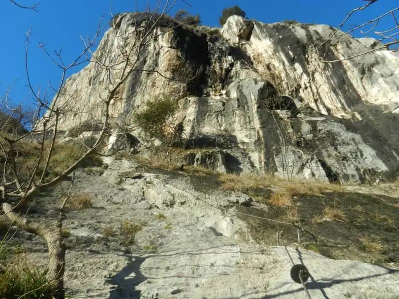
The Ferrata Colodri is an introductory equipped route, unfolding along the compact eastern walls of Monte Colodri that tower above Arco, in Trentino. The itinerary presents no high technical difficulties, offering a safe and progressive introduction to the world of via ferratas. It is essential to consider the risk of falling rocks along the entire route; therefore, wearing a helmet from the very start of the approach is strongly recommended. The route takes place in a strikingly scenic setting, passing alongside famous free-climbing sectors.
The morphology is characterized by a compact limestone wall, scored by slabs and dihedrals, developing with a predominantly oblique trajectory across broad ledges. The experience is marked by a pleasant, discontinuous rhythm, with short, well-equipped vertical sections interspersed with long horizontal traverses and walking stretches, offering a more panoramic and exploratory character than a technical or physically demanding one.
Approach
The starting point for the hike is Arco, in the province of Trento. After crossing the bridge over the Sarca River, take via Maini on the right, continuing straight until you spot the entrance to a campsite on the right. Just beyond, on the left, there is an information board, while on the right a clearing provides parking for a few cars. From here, with the silhouette of Cima Colodri clearly visible, the approach walk begins. Access the park area by following the white-and-red CAI markings for the via ferrata, reachable in about ten minutes of walking from the parking lot, identifiable by a plaque and signage.
Via Ferrata
The start of the route begins on a stepped ramp where you can proceed in free climbing without necessarily clipping into the safety cable. This first section, on well-stepped rock, gradually introduces you to the vertical environment. After these initial steps, an easy traverse to the right leads to another equipped ramp, where the cable mainly serves as a convenient handrail. Once this part is completed, turn right along a broad ledge that leads to the first short vertical section, well-structured and rich in excellent natural holds.
The route then angles left, alternating with a varied rhythm of small rock steps, trail sections, and walks along ledges. The subsequent development unfolds mainly on a false flat along a smooth ledge, technically very simple, heading decisively leftward while offering expansive views of the Sarca Valley. The environment here is more open and airy, yet remains very protected. You then tackle a couple of inclined slabs, equipped with rungs and stirrups, followed by some diagonal sections. A simple diagonal traverse to the left allows access to an easy crack, introducing the final part.
You thus arrive at a dihedral of about ten meters, whose modest difficulties are mitigated by the presence of rungs where natural holds thin out. After the last sloping slab, the metal equipment ends, and a short trail, exposed in spots but without difficulty, leads to the summit of Cima Colodri at 400 meters in altitude, where a cross and a characteristic small Madonna statue are located. The travel time for the via ferrata is about 30 minutes from the start, for a total of 40 minutes from the beginning of the hike.
The character of the route is decidedly horizontal and panoramic, with long stretches of movement along ledges that break up the verticality. The exposure is generally contained, increasing only in the last meters before the summit, while the rhythm is pleasantly discontinuous, allowing for observation pauses without fatigue.
Descent
From Cima Colodri, the descent takes place on the western side, until you intercept a junction with the CAI trail 431. For the most direct return, turn left towards Santa Maria di Laghel; from here, taking the small road on the left, descend towards Arco, then retrace the paved road back to the parking lot. This option takes about an hour from the end of the via ferrata, bringing the total hike to about 1 hour and 45 minutes.
For a longer and more varied loop itinerary, at the junction with trail 431 you can opt for the right, continuing towards Monte Colt and the Croce di Colt. Continuing to follow trail 431, descend towards the Sentiero Attrezzato degli Scaloni, an integral part of the Sentiero Attrezzato delle Cavre. After ascending the easy Sentiero degli Scaloni, at its end keep left, taking the CAI 408, which with a rather long route, partly on road, leads near the church of Santa Maria di Laghel, from where you descend to Arco and the vehicle. This variant takes about 4 hours from the end of the Ferrata Colodri, for a total of about 5 hours.
Useful Notes
Given the nature of the limestone rock, subject to erosion, and the climbing conditions on a frequented wall, it is essential to prepare your gear and put on your helmet before reaching the start of the via ferrata, to protect yourself from any rockfall from above. Despite this necessary precaution, the itinerary remains very elementary in character and represents an excellent choice for a first approach to equipped trails.
For cartography, the maps of the Alto Garda Valle di Ledro or the Valle dei Laghi and Alto Sarca from the 4Land series are recommended. The Arco area, extremely rich in crags and climbing gyms, offers numerous other proposals for via ferrata enthusiasts, such as the Ferrata Susatti, the Ferrata di Cima Rocca, or the Sentiero Attrezzato delle Laste at Cima Capi, or the Ferrata dell'Amicizia at Cima Sat near Riva del Garda. For experienced hikers, more challenging options include the exposed Ferrata a Mori or the difficult Ferrata Pisetta at Sarche. Moving north, you can find the Ferrata alla Cascata del Rio Ruzza or the Ferrata Artpinistica at Preore.
Track and weather
Plan the route
Preview the GPX track from the backend, download it for your GPS device, open parking directions, and check a short forecast before leaving.
Images
FAQ
What level of commitment does this via ferrata require?
ferrata.faqAnswers.commitment
How much elevation gain should I plan for?
The listed ferrata elevation gain is 280 m. Also consider approach, return and maximum altitude, because they can matter more than the equipped section alone.
Where is the route located?
Ferrata Colodri is located in Monte Colodri, Trento, Italy. Before leaving, check parking, access and current local conditions.
When is the best time to climb it?
The best season depends on altitude, aspect and lingering snow. Avoid storms, wet rock and uncertain conditions; start early and keep a margin for the return.
Gear and safety planning
Use the technical data on this page to plan equipment, timing and offline navigation. For a general checklist, read the equipment guide before opening the route in the app.
Video
Watch the route
Useful YouTube videos for getting a real feel for the route before you go.
Logbook
Route condition reports
Recent community notes about closures, snow, equipment damage, trail issues and current conditions.
Community
Reviews, check-ins and photos
-
0 reviews
2
2 climbers
1
Shared by the community
Community photos
Recent images uploaded by Sferrati members.
Reviews
Recent impressions from climbers who know the route.
No reviews yet
Be the first to review this via ferrata from the app.
Continue in the app
Track the climb, save maps offline, and sync this route to your personal profile.
Use the app to climb
Offline maps, tracking, saves, and profile sync.
Scan the code before leaving, install the app, and keep your route data ready when reception fades.
