
Technical data
- Difficulty
- Medio
- Status
- aperta
- Distance
- 19 km
- Total duration
- 8 h
- Approach
- 2 h 45 min
- Ferrata time
- 2 h 15 min
- Elevation gain
- 150 m
- Max altitude
- 2094 m
Route planning
How to plan Ferrata Costacurta al Teverone
Ferrata Costacurta al Teverone is in Monte Tavarone, Belluno, Italy and is rated Medio. Available route data lists about 8 h total time, 19 km of distance, 150 m of elevation gain.
For day planning, consider an approach of about 165 min, about 135 min on the cable, a maximum altitude near 2094 m. Reported route features include: Itinerario lungo.
The page includes a parking or driving-directions reference. A GPX track is available to review and download.
As with every via ferrata, evaluate season, lingering snow, storms, crowds and equipment condition. Page last updated on 7/4/2026.
Features
Description
Overview
The Ferrata Rino Costacurta unfolds across the northern walls of Monte Teverone, deep within the isolated and wild landscape of the Alpago region in Belluno. This loop route is defined by its considerable length and substantial overall elevation gain, which constitute its main challenge. The equipped route is technically moderate-easy, with no complex passages, but it stands out for its continuous exposure and a rhythm that moves across a succession of ledges and undulating terrain.
The environment is dominated by limestone and dolomite rock, with the trail snaking primarily along narrow grassy ledges and gullies, offering a progression that is more horizontal than vertical. The route is therefore more scenic and endurance-based than technical, suited to those seeking a long, exposed experience in a remote setting.
Approach
The starting point is near Casera Stabali, north of the hamlet of Plois (BL). From Pieve d'Alpago, take via Marconi following signs for Plois. At the entrance to the village, by a small newsstand, keep left uphill. You reach a large open area; just beyond, at the next fork, take the right onto a partially unpaved track that ends at a shelter with a table and benches (1050 m), which can be used for parking.
From the parking area, take the wide mule track marked CAI 965, reaching Casera Stabali (1070 m) in a few minutes. Continue uphill on trail 965/AV6 toward Passo di Valbona, passing the abandoned Casera Scalet Bassa (1170 m). After a clearing with a cross and commemorative square, the trail enters the woods, climbing with a sustained gradient but no technical difficulty, until it emerges into the open and reaches Scalet Alta (1590 m) in about 1 hour and 15 minutes. Ignore the signs for CAI 930 to the left, and continue a few meters on the 965 until you find signs to the right for trail 930 toward Forcella Bassa and the Ferrata Costacurta. Keeping right, the route proceeds south with ups and downs, skirts a rocky wall, and enters a gully with a compact floor that leads to the wide, grassy Forcella Bassa (1930 m), reached in about 2 hours and 15 minutes total. This junction is key: the 930 continues left toward Passo di Valbona, while for the via ferrata you keep right following AV7 markers. A grassy track branches off to the right toward the walls; after skirting a first rocky outcrop to the right following a blue triangle, you turn left toward the crest line, where you meet the metal plaque marking the start of the via ferrata (2065 m - 2h 45' total).
The approach is a classic medium-mountain hike, with significant elevation gain that physically prepares you for the main route. The morphology gradually shifts from dense forest to the high-altitude meadows of Forcella Bassa, introducing the open, exposed environment that will characterize the via ferrata.
Via Ferrata
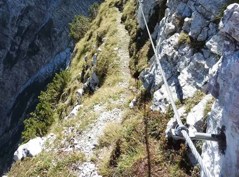
From the starting plaque, ascend a small gully with unstable ground, often with loose rock, which allows you to gain height quickly. Skirt a corner and tackle a first fairly vertical stepped climb. In this initial phase, you are on the northern side of the ridge, the Friulian side toward the Landres Negres valley. After an exposed but flat section, some equipped switchbacks bring you to the Veneto side of the ridge. From here, the route develops mainly along narrow grassy ledges, with a continuous alternation of climbs and short descents. You cross a very scenic and exposed section that leads to a first vertical step. After overcoming it, descend along a sloping earthy ramp to skirt a corner and reach a large grassy area suitable for a break.
The progression continues on an inclined ledge near a rock roof, a passage that works the arms due to the need to push outward. The route proceeds with a magnificent view of the north face of Teverone, until a grassy ledge gradually turns into a trail with no difficulty. The via ferrata resumes with its usual characteristics: short exposed traverses and passages on ledges alternate with climbing equipped gullies and a few rocky steps. After a succession of ledge passages, you overcome another vertical step, rich in holds. A new ledge leads to a loose gully to climb, which finally brings you to the grassy saddle of Monte Fagoreit (2094 m). The time for the via ferrata is about 2 hours and 15 minutes, for a total of 5 hours from the parking area.
The character of the route is defined by the continuity of exposure and the up-and-down rhythm on ledges, more than by pure verticality. The rock, often grassy and unstable in some gullies, requires attention to progression rather than arm strength. The experience is therefore scenic and endurance-based, with basic technique but a psychological challenge from the constant exposure on both sides of the ridge.
Descent
From the end of the via ferrata at Monte Fagoreit, take the ridge trail CAI 936 eastward. For the loop return, instead take trail 932, which descends steeply south into a basin, alternating grassy and scree sections. The signage in this valley is not optimal, and the ground is unstable in several points. Continuing the descent along the valley, skirt Col Fontana to the right, and you will glimpse Casera Venal, reached in about 1 hour and 30 minutes from the end of the via ferrata (1260 m). Passing by it, you join a drivable road, keeping right downhill. Pass Casera Crosetta (1156 m) and continue descending on the wide trail to an unmarked fork: leave the main track that descends and keep right on a slight uphill. Continue, ignoring various deviations, passing ruins and holiday homes until you intersect, at the Degnona locality, trail 931. From here, proceed westward on a track until you return to Casera Stabali, already encountered on the approach. The descent takes about 3 hours, for a total of 8 hours from the start of the hike.
The descent completes the loop with a long valley walk, often on loose ground and with a sometimes faint trail. This section requires attention to footing and navigation, representing a significant physical and mental effort after the hours on the via ferrata. The environment gradually returns to gentler characteristics, with meadows and old settlements, before rejoining the approach trail.
Useful Notes
The Ferrata Costacurta, sometimes referred to as a equipped trail, does have actual vertical sections that justify its classification as a via ferrata. Its level is moderate-easy, with constant exposure but no significant technical difficulty. However, several variables can increase its challenge: the overall route is very long and strenuous, with a demanding and little-traveled approach that requires excellent fitness. The numerous sections on grassy ground can become slippery in damp conditions, requiring maximum attention. The descent into the valley also has unstable sections. It is noted that, following a 2021 inspection, some fixtures were found to be deteriorated (missing pitons), a circumstance that requires continuous checking of anchors during progression.
The route is therefore a global challenge of endurance and concentration, where technical difficulty is secondary to duration, exposure, and the need to handle variable and sometimes unstable terrain. Checking anchors and assessing ground conditions are crucial aspects for safety.
Track and weather
Plan the route
Preview the GPX track from the backend, download it for your GPS device, open parking directions, and check a short forecast before leaving.
Images
FAQ
What level of commitment does this via ferrata require?
ferrata.faqAnswers.commitment
How much elevation gain should I plan for?
The listed ferrata elevation gain is 150 m. Also consider approach, return and maximum altitude, because they can matter more than the equipped section alone.
Where is the route located?
Ferrata Costacurta al Teverone is located in Monte Tavarone, Belluno, Italy. Before leaving, check parking, access and current local conditions.
When is the best time to climb it?
The best season depends on altitude, aspect and lingering snow. Avoid storms, wet rock and uncertain conditions; start early and keep a margin for the return.
Gear and safety planning
Use the technical data on this page to plan equipment, timing and offline navigation. For a general checklist, read the equipment guide before opening the route in the app.
Video
Watch the route
Useful YouTube videos for getting a real feel for the route before you go.
Logbook
Route condition reports
Recent community notes about closures, snow, equipment damage, trail issues and current conditions.
Community
Reviews, check-ins and photos
-
0 reviews
0
0 climbers
0
Shared by the community
Community photos
Recent images uploaded by Sferrati members.
No community photos yet
Open this route in the app to add the first photo.
Reviews
Recent impressions from climbers who know the route.
No reviews yet
Be the first to review this via ferrata from the app.
Continue in the app
Track the climb, save maps offline, and sync this route to your personal profile.
Use the app to climb
Offline maps, tracking, saves, and profile sync.
Scan the code before leaving, install the app, and keep your route data ready when reception fades.
