
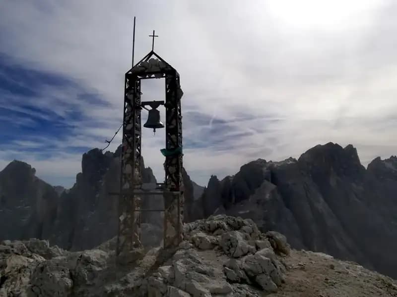
Ferrata del Mulaz
Pale di San Martino · Trento · Italy
Technical data
- Difficulty
- Moderatamente Difficile
- Status
- aperta
- Distance
- 15 km
- Total duration
- 7 h 30 min
- Approach
- 2 h
- Ferrata time
- 30 min
- Elevation gain
- 150 m
- Max altitude
- 2906 m
Route planning
How to plan Ferrata del Mulaz
Ferrata del Mulaz is in Pale di San Martino, Trento, Italy and is rated Moderatamente Difficile. Available route data lists about 7 h 30 min total time, 15 km of distance, 150 m of elevation gain.
For day planning, consider an approach of about 120 min, about 30 min on the cable, a maximum altitude near 2906 m. Reported route features include: Alta montagna, Itinerario lungo.
The page includes a parking or driving-directions reference. A GPX track is available to review and download.
As with every via ferrata, evaluate season, lingering snow, storms, crowds and equipment condition. Page last updated on 7/4/2026.
Features
Description
Overview
The Ferrata del Canalino offers a short but evocative route to the Passo del Mulaz, set in the wild, northern heart of the Pale di San Martino. Though the via ferrata section itself is brief, the itinerary unfolds as a full-scale mountain day, delivering a long, immersive experience through a Dolomite landscape of extraordinary beauty and solitude.
Approach
The route begins at the Passo di Vales (2031 m), on the border between the provinces of Trento and Belluno. Access is from Paneveggio on the Trentino side or from Falcade di Sopra on the Veneto side; parking on the Trentino side of the pass is recommended. From the pass, head southeast on trail 751, which starts as a dirt road and soon becomes a wide mule track. The intermediate goal is the Forcella di Venegia (2212 m). Before reaching it, ignore the path to Cima del Lago. At the pass, bear right, following trail markers 749, which descend across the slope at mid-height, also skipping the right-hand turn (trail 750) toward Malga Venegia. This section crosses broad meadows with a pleasant, rolling terrain, dominated by the towering Dolomite walls that loom over the pastures. Continue to an important junction at about 2045 meters (roughly 1 hour from the car park), where you turn left and ascend the Vallon della Venegiota. The main trail climbs toward the Passo di Venegiata, but after about 10 minutes you must carefully spot a very faint track branching off to the right across the grass. A bit of route-finding instinct is needed to aim for a debris tongue spilling down from the valley you need to ascend. This section, in an open, poorly marked landscape, demands good terrain reading. Once you cross the meadows and reach the tongue, climb it (it's best to stay on the grass to its left). After the debris tongue, cut south onto rocky ground, where the first cairns begin to appear. Shortly after, high to the left, the Passo del Mulaz will come into view at the top of a narrow gully. The track becomes clearer, and as the gully narrows, metal fixtures appear on the left side of the path, marking the start of the Ferrata del Mulaz (2390 m), reached about 2 hours from the car park. The approach is a moderate-paced walk, mixing easy trail sections with more demanding route-finding in a grand and remote setting.
Via Ferrata
The protected climb begins on a sloping ridge of solid rock rich in natural holds, then continues over easy protected steps. You reach a ridge that is rounded with good exposure, offering the first deep views into the valley below. The route continues across a sloping slab where the cable serves mainly as a handrail, given the modest angle and generally good rock. A final short protected section of easy climbing concludes the actual via ferrata. The ascent is vertical but not technically demanding, with a steady, continuous rhythm. From here, proceed free-climbing without a fixed path, following the cables of a material lift that lead directly to the Passo del Mulaz (2619 m). This final stretch, over scree and boulders, takes about 40 minutes, bringing the total time to roughly 2 hours and 45 minutes. The via ferrata itself is thus short and low in technical difficulty, but it serves as an efficient vertical connector in a narrow, debris-filled gully. From the pass, following trail 751 (which will be your return route), a detour to the summit of Mulaz is highly recommended. Just before descending toward the rifugio, a track branches off to the left, climbing upward. Ascend to a saddle around 2800 meters, then turn right onto a beautiful, exposed debris ledge that traverses around the mountain. This spectacular, horizontal, airy section runs along the mountain's flank with breathtaking views, finally leading to the large summit cross of Mulaz (2906 m), reached in about 3 hours and 30 minutes total. The final ascent is thus a ridge and ledge itinerary, more challenging for its exposure than its technique, with a distinctly panoramic character.
Descent
After enjoying the 360-degree panorama from the summit, begin the long return. The first part leads back to the junction just below the Passo del Mulaz. From there, a few minutes of descent bring you to the Rifugio Volpi al Mulaz (2560 m). From the rifugio, follow trail 751 to the left toward the Passo dei Fochet, reached about 2 hours and 30 minutes from the summit (6 hours total); this descent section, which runs through a side valley, includes a few protected passages over short slabs or to overcome small rock steps. From the Passo dei Fochet, keep left on trail 751, which leads first to the Passo di Venegiota (2303 m) and then to the Forcella di Venegia, already passed on the approach. From the forcella, return to the Passo di Valles via the approach trail, completing the loop in about 7 hours and 30 minutes total. The descent is a long, continuous hiking route that demands endurance and offers a different perspective on the massif.
Useful Notes
The Ferrata del Mulaz is quite short and, in itself, not technically significant. Its value lies in the spectacular and isolated setting of the northern section of the Pale di San Martino, far less frequented than the southern side. The itinerary offers a sense of adventure, also due to the dated and not always obvious trail markings; in fog, navigation can become difficult. The metal fixtures are rusty but in overall good condition. The ascent to the summit of Mulaz requires attention due to exposure but presents no high technical difficulties. Beware of residual snow, which can persist early in the season in the gullies and along the final summit section, making some passages more delicate. For navigation, the use of detailed cartography, such as that of the Parco Naturale Paneveggio e Pale di San Martino, is recommended. The entire route is an experience that rewards more with the grandeur of the environment and the sense of exploration than with pure climbing challenge.
Track and weather
Plan the route
Preview the GPX track from the backend, download it for your GPS device, open parking directions, and check a short forecast before leaving.
Images
FAQ
What level of commitment does this via ferrata require?
ferrata.faqAnswers.commitment
How much elevation gain should I plan for?
The listed ferrata elevation gain is 150 m. Also consider approach, return and maximum altitude, because they can matter more than the equipped section alone.
Where is the route located?
Ferrata del Mulaz is located in Pale di San Martino, Trento, Italy. Before leaving, check parking, access and current local conditions.
When is the best time to climb it?
The best season depends on altitude, aspect and lingering snow. Avoid storms, wet rock and uncertain conditions; start early and keep a margin for the return.
Gear and safety planning
Use the technical data on this page to plan equipment, timing and offline navigation. For a general checklist, read the equipment guide before opening the route in the app.
Video
Watch the route
Useful YouTube videos for getting a real feel for the route before you go.
Logbook
Route condition reports
Recent community notes about closures, snow, equipment damage, trail issues and current conditions.
Community
Reviews, check-ins and photos
-
0 reviews
0
0 climbers
0
Shared by the community
Community photos
Recent images uploaded by Sferrati members.
No community photos yet
Open this route in the app to add the first photo.
Reviews
Recent impressions from climbers who know the route.
No reviews yet
Be the first to review this via ferrata from the app.
Continue in the app
Track the climb, save maps offline, and sync this route to your personal profile.
Use the app to climb
Offline maps, tracking, saves, and profile sync.
Scan the code before leaving, install the app, and keep your route data ready when reception fades.
