
Ferrata di Punta Marmotta
Punta Marmotta · Bolzano · Italy
Technical data
- Difficulty
- Moderatamente Difficile
- Status
- aperta
- Distance
- 4,7 km
- Total duration
- 3 h
- Approach
- 45 min
- Ferrata time
- 1 h 30 min
- Elevation gain
- 290 m
- Max altitude
- 2340 m
Route planning
How to plan Ferrata di Punta Marmotta
Ferrata di Punta Marmotta is in Punta Marmotta, Bolzano, Italy and is rated Moderatamente Difficile. Available route data lists about 3 h total time, 4,7 km of distance, 290 m of elevation gain.
For day planning, consider an approach of about 45 min, about 90 min on the cable, a maximum altitude near 2340 m.
The page includes a parking or driving-directions reference. A GPX track is available to review and download.
As with every via ferrata, evaluate season, lingering snow, storms, crowds and equipment condition. Page last updated on 7/4/2026.
Description
Overview
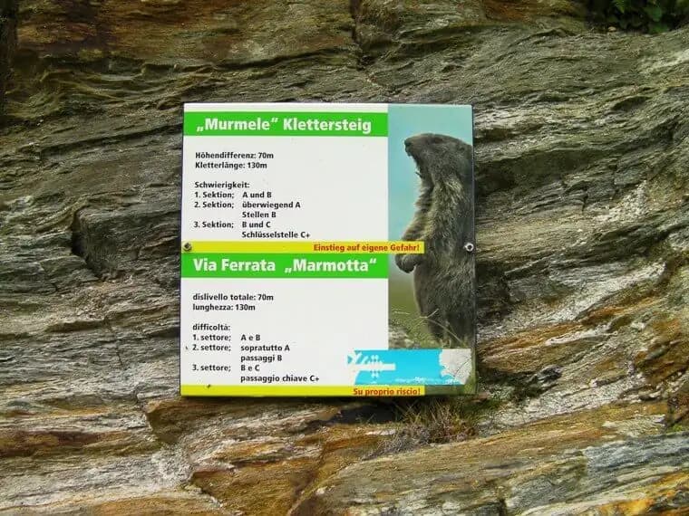
The Ferrata di Punta Marmotta is a recently equipped route that unfolds along the prominent granite spur north of the Rifugio Nino Corsi in the Martello Valley. The progression follows a modular approach: the first two sections present moderate difficulty, while the third, more technical and vertical segment can be bypassed. Overall, this is a moderate via ferrata. A key environmental factor is the constant northern exposure, which keeps the wall shaded and cool for many hours, influencing the rock temperature and its tactile feel.
Approach
The route begins at the end of the parking area in Val Martello (Martelltal), a long side valley of the Val Venosta that stretches about 30 km into the Stelvio National Park. To reach it, take the road from Goldrano that climbs the valley, passing through Ganda di Martello and Lago Gioveretto.
The first stop is the Rifugio Genziana (2051 m), easily accessible and offering additional rest opportunities. From here, a roughly 30-minute walk along trails 151, 36, or 37 (all of similar effort) leads to the Rifugio Nino Corsi (2265 m). Trail 151 is the most direct and allows you to reach the start without necessarily passing through the refuge.
From the hut, the silhouette of Punta Murmele, the final objective, is clearly visible to the west. Continuing along the path, you soon encounter a fork: ignore the left-hand track (which will be the return route) and keep right toward the west, reaching the often-shaded start of the Via Ferrata Murmele in a few minutes. The approach from the parking area, taken at a leisurely pace, takes about 45 minutes.
Via Ferrata
The route is structured into three distinct segments, separated by two escape routes on the left that allow you to leave the via and reconnect with the trail back to the refuge.
The first section begins with an initial movement to the left, alternating short vertical stretches with oblique progressions to the right. The terrain is that of an articulated spur, with solid, well-stepped rock that allows for a fluid, low-exposure climb. After the first 30-40 meters, you encounter the first escape route.
Beyond it, you tackle some easy rock steps and traverse a panoramic ledge to the right-a horizontal stretch that offers a breather before the climb resumes. The progression continues with a few diagonal pitches, where a couple of slightly more challenging moves are concentrated, before reaching the second escape route. This point is ideal for assessing whether to continue, as the character of the route changes noticeably.
The third and final section starts easily but soon presents a more articulated and vertical wall. Here you face a traverse to the right characterized by good footholds but less obvious handholds-a passage that demands greater trust in the cable and careful searching for holds. Shortly after, you reach the crux of the route: a roof that is bypassed on the right side, then climbed up in full exposure with the help of some stirrups, in a move that requires a certain athletic spark but remains within reach. The finale features one last vertical wall and a few rock steps before the end of the equipped route, on a summit terrace.
Descent
From the top of the via ferrata, a clear trail leads easily back to the nearby Rifugio Nino Corsi in about 15 minutes. From the refuge, return to the parking area by retracing one of the approach trails. The total time for the entire excursion is about 3 hours.
For a longer outing, from the end of the via ferrata you can take trail 103 and climb to the Rifugio Martello (2600 m), a prime panoramic point overlooking the glaciers of Punta Marmotta, Monte Cevedale, and the surrounding peaks.
Useful Notes
The Ferrata di Punta Marmotta makes for a pleasant excursion in an alpine environment at a still relatively moderate altitude. Thanks to its well-calibrated progression of difficulty and the presence of escape routes, it lends itself excellently as a first approach to this type of activity. The short approach and return make it an ideal choice for a half-day outing in the splendid setting of the Martello Valley and the Stelvio National Park. For maps, it is recommended to refer to the dedicated map of the Ortles, Cevedale, and Val di Sole area.
Track and weather
Plan the route
Preview the GPX track from the backend, download it for your GPS device, open parking directions, and check a short forecast before leaving.
Images
FAQ
What level of commitment does this via ferrata require?
ferrata.faqAnswers.commitment
How much elevation gain should I plan for?
The listed ferrata elevation gain is 290 m. Also consider approach, return and maximum altitude, because they can matter more than the equipped section alone.
Where is the route located?
Ferrata di Punta Marmotta is located in Punta Marmotta, Bolzano, Italy. Before leaving, check parking, access and current local conditions.
When is the best time to climb it?
The best season depends on altitude, aspect and lingering snow. Avoid storms, wet rock and uncertain conditions; start early and keep a margin for the return.
Gear and safety planning
Use the technical data on this page to plan equipment, timing and offline navigation. For a general checklist, read the equipment guide before opening the route in the app.
Video
Watch the route
Useful YouTube videos for getting a real feel for the route before you go.
Logbook
Route condition reports
Recent community notes about closures, snow, equipment damage, trail issues and current conditions.
Community
Reviews, check-ins and photos
-
0 reviews
0
0 climbers
0
Shared by the community
Community photos
Recent images uploaded by Sferrati members.
No community photos yet
Open this route in the app to add the first photo.
Reviews
Recent impressions from climbers who know the route.
No reviews yet
Be the first to review this via ferrata from the app.
Continue in the app
Track the climb, save maps offline, and sync this route to your personal profile.
Use the app to climb
Offline maps, tracking, saves, and profile sync.
Scan the code before leaving, install the app, and keep your route data ready when reception fades.
