
Stefano 982T
Feb 14, 2026
Una perla di ferrata
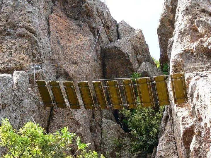
Difficile e appagante, si può sperimentare tutte le situazioni che si possono trovare in ferrata, salite, discese, traversi esposti, scalette e ponte tibetano.
1

Route planning
Ferrata Sant'Antone is in Monte Serra, Pisa, Italy and is rated Difficile. Available route data lists about 1 h 50 min total time, 3,3 km of distance, 120 m of elevation gain.
For day planning, consider an approach of about 10 min, about 70 min on the cable, a maximum altitude near 540 m. Reported route features include: Ponti sospesi, Avvicinamento corto.
The page includes a parking or driving-directions reference. A GPX track is available to review and download.
As with every via ferrata, evaluate season, lingering snow, storms, crowds and equipment condition. Page last updated on 7/4/2026.
The Ferrata Sant'Antone, in the Monti Pisani range, is a technical and athletic route that unfolds between 500 and 600 meters in elevation. The total vertical gain is modest, but the character of the route is defined by a succession of extremely exposed and often overhanging traverses that demand specific preparation and arm strength. The route runs along a compact limestone wall, shaped into discontinuous ledges and pinnacles, offering a continuous and physically demanding progression.
The route begins from a parking area along Provincial Road 56, heading toward Monte Serra from Buti (PI). The spot is marked by a fountain and a house on the opposite side of the road. After parking, walk up the paved road for about two hundred meters to a sign indicating the access. Then take a climbing trail, marked with white-red paint. In five minutes you reach a fork: turning right leads to the start of the via ferrata in about ten minutes total from the car. The left branch quickly leads under the characteristic overhangs of the first passages, but without direct access.
The route immediately attacks with an oblique and exposed traverse that crosses a ridge, forcing a progression in friction with continuous traction on the cable. This style of movement, on compact and polished rock, characterizes the entire climb. Next, you face a vertical wall with a slightly overhanging start, eased by the presence of rock steps. This is followed by a particularly exposed horizontal traverse, where you must move in friction while pulling on the cable, paying attention to an overhanging rock ledge above. A subsequent descent passage, not trivial, requires leaning out to find the best footholds.
The pace is relentless and offers no respite: you immediately restart on a demanding traverse to the left, slightly overhanging, which enters and goes around a gully to exit on the opposite side. Then you climb diagonally into an area where a roof forces you to duck. After tackling a final vertical wall of moderate difficulty, you reach an escape route. This allows you to reach the end of the via ferrata in five minutes (climbing) or return to the start in ten (descending).
Continuing, follow the signs to the left. An oblique traverse leads, after another exposed ridge, to a descent passage where it is crucial to study your body position to avoid being slammed against the rock. The route continues with an alternation of climbs, descents, chimneys, and generally difficult traverses that require athleticism and arm strength. Once this section is finished, you approach the final stretch.
The last section partially abandons traverses for a more vertical progression, presenting two passages of greater difficulty. The first is a decidedly overhanging chimney, requiring good technique for the first two moves before becoming easier. After a short break in the equipment, continue to the right toward the second challenging passage: climbing up a large boulder in a straddle position, carefully evaluating the few holds on both sides. Overcoming a slight overhang here may require a couple of decisive pulls. After these two sections, some exposed but not difficult traverses lead to the last fork. To the right, the via ferrata ends; to the left, a traverse leads to a short but exposed suspension bridge, which introduces the final key passage.
This is a vertical section that tests both technique and physical strength, especially due to the lack of holds and accumulated fatigue. The main difficulty is detaching from the bridge, particularly for shorter people. Once you figure out how to climb onto the first bolt, move to the right side of the wall near two characteristic Y-shaped stirrups, which help in climbing the wall, also slightly overhanging. Climb first to the right and then to the left of the cable, thus completing the difficult vertical passage. Five vertical bolts finally lead to the Italian flag, marking the end of the Ferrata Sant'Antone. The climbing time from the start is about 1 hour and 15 minutes (1 hour and 25 minutes from the parking lot).
From the end of the via ferrata, continue on a faint trail to the left, which quickly leads to a series of boulders to climb up until you reach a clearing called Ghiaccietto. Cross the clearing heading to the right, then take the CAI trail that leads to the first escape route encountered on the ascent. Continue the descent to the start of the via ferrata and from there return to the parking lot by retracing the approach trail. Caution: after the intersection with the escape route, the trail is easy to lose, being poorly marked. The drivable road is, however, a few dozen meters lower down; by crossing shrubs and scree sections, you can still reach it, then take it to the left. The descent takes about 25 minutes from the end of the via ferrata, for a total hike of about 1 hour and 45 minutes from the parking lot.
This via ferrata, recently built and managed by the CAI section of Pontedera, thanks to its low elevation is practically climbable year-round. The limestone rock offers excellent friction, a fundamental element in the numerous friction and traverse sections. The route is very varied, presenting an abundance of traverses, challenging descent passages, walls, and chimneys. It requires good arm strength due to the high number of overhanging sections. Each bolt is numbered, allowing you to orient yourself knowing that the entire via ferrata consists of about 170 elements. The descent section along the ridge is particularly thrilling. Given the not excessive length and the prevalence of traverses, it lends itself well, for experienced hikers, to being done in reverse as well, possibly avoiding the last section between the suspension bridge and the end.
Track and weather
Preview the GPX track from the backend, download it for your GPS device, open parking directions, and check a short forecast before leaving.
ferrata.faqAnswers.commitment
The listed ferrata elevation gain is 120 m. Also consider approach, return and maximum altitude, because they can matter more than the equipped section alone.
Ferrata Sant'Antone is located in Monte Serra, Pisa, Italy. Before leaving, check parking, access and current local conditions.
The best season depends on altitude, aspect and lingering snow. Avoid storms, wet rock and uncertain conditions; start early and keep a margin for the return.
Use the technical data on this page to plan equipment, timing and offline navigation. For a general checklist, read the equipment guide before opening the route in the app.
Video
Useful YouTube videos for getting a real feel for the route before you go.
Logbook
Recent community notes about closures, snow, equipment damage, trail issues and current conditions.
Community
4.3
3 reviews
11
2 climbers
6
Shared by the community
Recent images uploaded by Sferrati members.
Recent impressions from climbers who know the route.
Feb 14, 2026
Difficile e appagante, si può sperimentare tutte le situazioni che si possono trovare in ferrata, salite, discese, traversi esposti, scalette e ponte tibetano.
1

Feb 5, 2026
Da rifare

Feb 5, 2026
La ferrata Sant'Antone che si trova nel comune di Buti è molto impegnativa possiamo tranquillamente affermare che la più difficile del centro sud d'Italia. Al momento è tutta percorribile anche se per un cavillo burocratico su Google risulta ancora chiusa per una vecchia frana di tre anni fa. Appassionati di ferrate vengono da tutta Italia percorrerla e rimangono tutti molto soddisfatti ed appagati sia per il panorama che per l'impegno fisico. Venite anche voi a scoprire questo gioiello ha due passi tra Lucca e Pisa dove la nostra passione si unisce alla tradizione del buon cibo toscano.
4
Track the climb, save maps offline, and sync this route to your personal profile.
Use the app to climb
Scan the code before leaving, install the app, and keep your route data ready when reception fades.
