
Technical data
- Difficulty
- Moderatamente Difficile
- Status
- aperta
- Distance
- 7,5 km
- Total duration
- 4 h 15 min
- Approach
- 1 h
- Ferrata time
- 1 h 30 min
- Elevation gain
- 450 m
- Max altitude
- 1891 m
Route planning
How to plan Ferrata Ziel
Ferrata Ziel is in Gingglegg, Bolzano, Italy and is rated Moderatamente Difficile. Available route data lists about 4 h 15 min total time, 7,5 km of distance, 450 m of elevation gain.
For day planning, consider an approach of about 60 min, about 90 min on the cable, a maximum altitude near 1891 m. Reported route features include: Ponti sospesi, Funivia al ritorno, Funivia all'andata.
The page includes a parking or driving-directions reference. A GPX track is available to review and download.
As with every via ferrata, evaluate season, lingering snow, storms, crowds and equipment condition. Page last updated on 7/4/2026.
Features
Description
Overview
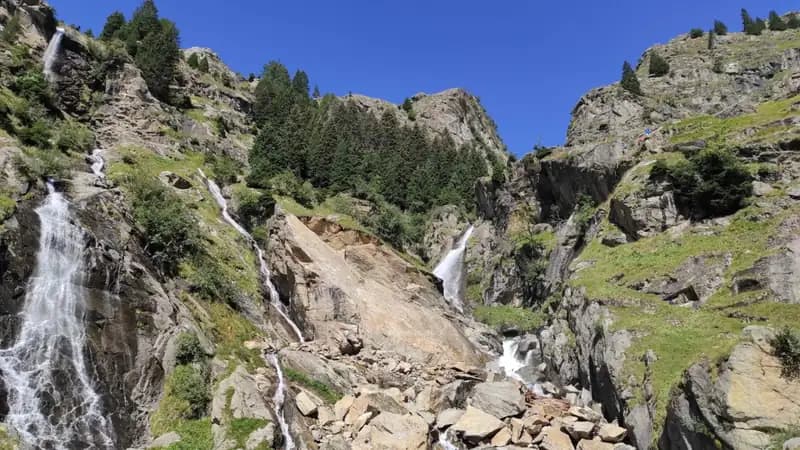
The Ziel via ferrata, also known as the Rio di Tel ferrata, is a moderately difficult route that opened in August 2020. It follows the roaring Zielbach stream deep within the Texel Group Nature Park, culminating on the panoramic summit of the Gingglegg at 1,891 meters. Located just a short distance from the famous Partschins Waterfall in the Vinschgau Valley, this route combines technical climbing with the constant presence of water, delivering a dynamic and immersive experience.
Approach
Access begins at the Texel Cable Car parking lot in Rablà, a hamlet of Partschins, easily reached by car from Merano and also served by public bus. From the top station of the cable car, take Trail No. 24, which coincides with the Meran High Trail, and follow it for 45 minutes to the Nasereit Hut (1,523 m). The trail starts with a moderate ascent, followed by a short descent. After passing the hut, cross the bridge over the stream and immediately turn left, following the obvious red-marked path along the bank for about 15 minutes to the start of the via ferrata. The total approach time is roughly one hour. The silhouette of the Gingglegg, beneath whose wall the route unfolds, dominates the view ahead.
Terrain and Pace: The approach follows a well-maintained hiking trail with a steady rhythm and never overly steep gradients. The environment is classic mid-altitude Vinschgau terrain, with sparse forests and sweeping views of the valley. The constant sight of the gorge and the summit ahead gradually prepares you for the technical challenge to come.
Via Ferrata
The equipped route, about 530 meters long, is divided into 10 sections of 12 mm diameter steel cable, numbered in descending order from top to bottom on small metal plates. The anchor bolts, a generous 20 mm in diameter, are often placed close together, sometimes less than a meter apart. The difficulties are concentrated in the middle section and include moderate-grade passages, with one rated as fairly challenging.
The first section climbs the right side of the gorge (left orographic) up a sloping rock slab, aided by metal rungs and handholds, to a rocky step beside the first waterfall. A short equipped connecting section leads to a stream crossing with two options: an unstable suspension bridge made of longitudinal planks, or two Tyrolean traverses (flying foxes). These consist of two parallel steel cables (one 12 mm load-bearing cable for the pulley and one safety cable); as no usage instructions are provided, it is recommended to be familiar with this technique or to seek information beforehand.
After another connecting section, the route continues opposite a penstock on the far bank. You then ascend a grassy slope using wide metal rungs, heading toward a prominent rock roof. The crux involves staying to the right of the roof with a vertical slab move, then traversing left above the overhang. Section 5, with rather narrow stirrups, leads to a vertical wall, followed by an exposed slab on the right. In this area, on the right, you can see an equipped escape route that leads back toward the suspension bridges.
The subsequent section reaches the metal box for the summit register (not present at the inauguration) and continues over grassy boulders until it meets Trail No. 8, accessed by climbing over a wooden fence. A bench on the left offers a convenient spot to rest and remove your via ferrata gear. The climbing time from the start is about 1 hour and 30 minutes, for a total of 2 hours and 30 minutes from the top cable car station.
Experience and Character of the Route: The ferrata unfolds mainly on smooth, compact paragneiss slabs typical of the Texel Group, often wet from the stream's spray. The pace is uneven, alternating vertical rock sections with short walks on ledges and grassy slopes. Exposure is constant and significant, especially on the traverses above the stream and the slabs of the central section. The character is distinctly technical and varied, with particular attention required for managing the Tyrolean traverses and moves on wet rock. The scenery is outstanding, with continuous views of the gorge below and the surrounding peaks.
Descent
From the exit of the ferrata, descend along Trail No. 8, passing the Kaserstein (a hut nestled against a large boulder), to reach the Nasereit Hut in 45 minutes. From the hut, retrace your steps along Trail No. 24 (Meran High Trail) back to the top station of the Texel Cable Car, a walk of about one hour. The total duration of the entire excursion, including approach, ferrata, and descent, is approximately 4 hours and 15 minutes.
Terrain and Pace: The descent follows a forest trail that is steep in the first part, gradually easing as you approach the hut. The pace is brisk but without technical difficulty, offering a pleasant cool-down after the demands of the ferrata, with the chance to observe the gorge environment from a different angle.
Useful Notes
The ferrata can become slippery and difficult to navigate in rain or high humidity due to the high proportion of smooth rock slabs. A careful assessment of the weather forecast before heading out is essential. The Vinschgau Valley is rich in alternatives for via ferrata enthusiasts, with routes of varying difficulty such as the Trafoi Ferrata, Tabaretta, Croda di Cengles, Hoachwool, Knott, Murmele, Heini Holzer, Stuller Wasserfall, and the more recent Larix Ferrata in the Schnalstal Valley.
Track and weather
Plan the route
Preview the GPX track from the backend, download it for your GPS device, open parking directions, and check a short forecast before leaving.
Images
FAQ
What level of commitment does this via ferrata require?
ferrata.faqAnswers.commitment
How much elevation gain should I plan for?
The listed ferrata elevation gain is 450 m. Also consider approach, return and maximum altitude, because they can matter more than the equipped section alone.
Where is the route located?
Ferrata Ziel is located in Gingglegg, Bolzano, Italy. Before leaving, check parking, access and current local conditions.
When is the best time to climb it?
The best season depends on altitude, aspect and lingering snow. Avoid storms, wet rock and uncertain conditions; start early and keep a margin for the return.
Gear and safety planning
Use the technical data on this page to plan equipment, timing and offline navigation. For a general checklist, read the equipment guide before opening the route in the app.
Video
Watch the route
Useful YouTube videos for getting a real feel for the route before you go.
Logbook
Route condition reports
Recent community notes about closures, snow, equipment damage, trail issues and current conditions.
Community
Reviews, check-ins and photos
-
0 reviews
0
0 climbers
0
Shared by the community
Community photos
Recent images uploaded by Sferrati members.
No community photos yet
Open this route in the app to add the first photo.
Reviews
Recent impressions from climbers who know the route.
No reviews yet
Be the first to review this via ferrata from the app.
Continue in the app
Track the climb, save maps offline, and sync this route to your personal profile.
Use the app to climb
Offline maps, tracking, saves, and profile sync.
Scan the code before leaving, install the app, and keep your route data ready when reception fades.
