
Sentiero Attrezzato Bonacossa
Dolomiti di Sesto · Belluno · Italy
Technical data
- Difficulty
- Moderatamente Difficile
- Status
- aperta
- Distance
- 17,5 km
- Total duration
- 7 h
- Approach
- 5 min
- Ferrata time
- 5 h 15 min
- Elevation gain
- 624 m
- Max altitude
- 2495 m
Route planning
How to plan Sentiero Attrezzato Bonacossa
Sentiero Attrezzato Bonacossa is in Dolomiti di Sesto, Belluno, Italy and is rated Moderatamente Difficile. Available route data lists about 7 h total time, 17,5 km of distance, 624 m of elevation gain.
For day planning, consider an approach of about 5 min, about 315 min on the cable, a maximum altitude near 2495 m. Reported route features include: Ghiacciaio, Scale, Itinerario lungo, Funivia all'andata.
The page includes a parking or driving-directions reference. A GPX track is available to review and download.
As with every via ferrata, evaluate season, lingering snow, storms, crowds and equipment condition. Page last updated on 7/4/2026.
Features
Description
Overview
The Sentiero Attrezzato Bonacossa is an alpine traverse that runs the length of the Cadini Group, alternating between hiking trails and secured passages. While it doesn't present extreme technical difficulties, the route demands solid physical preparation and good familiarity with alpine terrain, especially in the final section starting from Forcella de Rinbianco. The trail is characterized by a broken rhythm, with constant elevation changes that make the total vertical gain far exceed the net gain. The environment is classic Dolomites, progressing along ledges, gullies, and passes that offer a panoramic and varied experience. Be aware of possible residual snowfields, even in the height of summer.
Approach
The starting point is the top station of the Col de Varda chairlift, on the eastern side of Lago di Misurina in the Sexten Dolomites. If arriving by car, it's recommended to park in the southern area of the lake near the Hotel Alpenrose and walk to the lifts. Using the chairlift eliminates the hiking approach, allowing you to start the via ferrata immediately. Alternatively, you can hike up from the lake (1756 m) to the Rifugio Col de Varda (2115 m) in about 45 minutes via the steep trail marked 120.
Via Ferrata
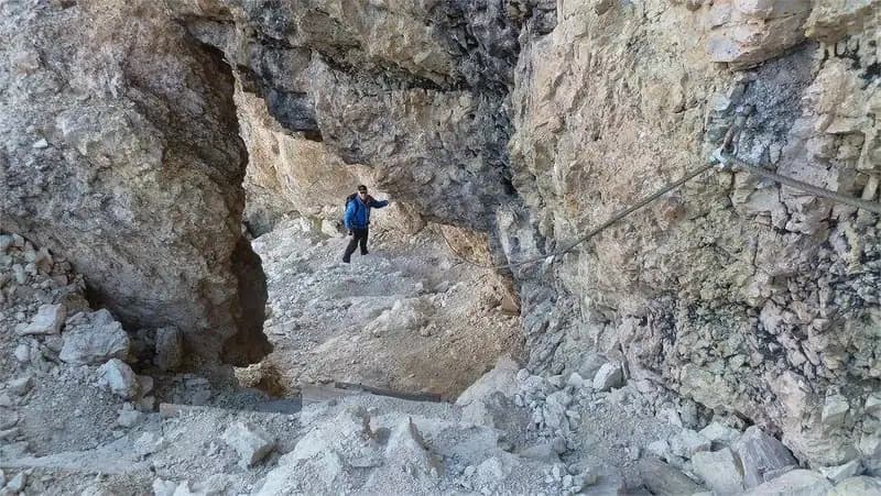
From the Rifugio Col de Varda, locate the start of the Sentiero Attrezzato Bonacossa (trail marker 117) thanks to a metal plaque and red blazes. The route heads north, with a moderate initial gradient that becomes steeper on the steep ascent to Forcella di Misurina. You climb a debris-filled gully on the right side, partially equipped with steel cables and embedded wooden steps. The terrain is a narrow, gravelly channel that leads to the pass (2395 m) in about 45 minutes from the start.
From the pass, the view opens onto the deep basin of the Ciadin della Neve and the next objective: the steep Forcella del Diavolo. The descent from the narrow notch of Forcella Misurina is technical and challenging: you tackle a rocky gully using steel cables to overcome two vertical steps and a traverse to the right, also passing through a hole in the rock that's been equipped. This exposed but well-protected passage leads to the floor of the Ciadin della Neve (2250 m) after about 45 minutes of descent. Here you intersect trail 118; continue instead on trail 117, which immediately begins climbing the left side of the valley northeastward, heading toward Forcella del Diavolo.
The climb is steep and varied, involving the negotiation of two metal ladders that overcome two rock steps. After the ladders, turn right and ascend the upper part of the gully, where the footing can be unstable due to loose debris. You reach Forcella del Diavolo (2380 m) in about 40 minutes from the Ciadin della Neve. The setting is severe, dominated by vertical walls and a panorama that stretches across the Tre Cime di Lavaredo.
From the broad pass, the descent toward the Rifugio Fonda Savio begins. You descend staying on the right side of a steep scree slope, often affected by residual snow well into the season. After about 40 minutes, you reach the Rifugio Fonda Savio (2367 m), a crucial trail junction in the area.
Leaving the refuge, trail 117 continues north. After a short steep equipped section, you descend a gully and traverse right onto a ledge, crossing a wooden footbridge. You descend again to the Ciadin della Neve, ignoring the right turn for trail 112, and cross the valley floor (often snow-covered) until reaching Forcella de Rinbianco (2176 m) in about 30 minutes from the refuge.
From here, the route turns right toward the Rifugio Auronzo. The next section runs along a partially exposed and equipped ledge, very panoramic over the Val de le Cianpedele and the Cadini chain. After crossing a footbridge and some war relics, you encounter a junction: continue left on trail 117, tackling a marked climb to bypass the east face of the Ciadin delle Bisse. This sector, the most adrenaline-filled of the entire itinerary, begins with small rock steps and a diagonal ramp with a cable on the left, followed by a very gently sloping ladder. The equipped passages are not technically difficult, but the exposure and the possibility of wet ground recommend using via ferrata gear. You continue on ledges and short, loose gullies, always secured at the most exposed points, until gaining a pass at 2300 m, crossing from the east side to the west. From here, the route becomes more straightforward and comfortable. After passing the entrance to a tunnel (optional), you finally reach the meadows of the Rifugio Auronzo (2320 m) in about 5 hours and 15 minutes total.
Descent
For the return to Lago di Misurina, the most common option is to take the public bus. Alternatively, you can descend on foot via the popular trail 101, which with a constant but never excessive gradient leads to the lake in about 1 hour and 30 minutes from the refuge, for a total of about 7 hours of hiking.
Useful Notes
The elevation gain is purely indicative due to the numerous ups and downs; the itinerary is therefore more strenuous than it might appear. The section from Forcella de Rinbianco is exposed and panoramic, but always well-equipped. The passages with cables and ladders present no significant technical difficulties and primarily serve as useful handrails. Note that following a landslide in 2017, the crossing section at Forcella di Misurina is closed; it is possible to bypass the issue by starting the itinerary directly from the Ciadin de la Neve.
Track and weather
Plan the route
Preview the GPX track from the backend, download it for your GPS device, open parking directions, and check a short forecast before leaving.
Images
FAQ
What level of commitment does this via ferrata require?
ferrata.faqAnswers.commitment
How much elevation gain should I plan for?
The listed ferrata elevation gain is 624 m. Also consider approach, return and maximum altitude, because they can matter more than the equipped section alone.
Where is the route located?
Sentiero Attrezzato Bonacossa is located in Dolomiti di Sesto, Belluno, Italy. Before leaving, check parking, access and current local conditions.
When is the best time to climb it?
The best season depends on altitude, aspect and lingering snow. Avoid storms, wet rock and uncertain conditions; start early and keep a margin for the return.
Gear and safety planning
Use the technical data on this page to plan equipment, timing and offline navigation. For a general checklist, read the equipment guide before opening the route in the app.
Video
Watch the route
Useful YouTube videos for getting a real feel for the route before you go.
Logbook
Route condition reports
Recent community notes about closures, snow, equipment damage, trail issues and current conditions.
Community
Reviews, check-ins and photos
-
0 reviews
0
0 climbers
0
Shared by the community
Community photos
Recent images uploaded by Sferrati members.
No community photos yet
Open this route in the app to add the first photo.
Reviews
Recent impressions from climbers who know the route.
No reviews yet
Be the first to review this via ferrata from the app.
Continue in the app
Track the climb, save maps offline, and sync this route to your personal profile.
Use the app to climb
Offline maps, tracking, saves, and profile sync.
Scan the code before leaving, install the app, and keep your route data ready when reception fades.
