
Technical data
- Difficulty
- Facile
- Status
- aperta
- Distance
- 13 km
- Total duration
- 5 h 30 min
- Approach
- 2 h
- Ferrata time
- 45 min
- Elevation gain
- 1006 m
- Max altitude
- 2528 m
Route planning
How to plan Sentiero Attrezzato Gino Badia
Sentiero Attrezzato Gino Badia is in Dolomiti di Fassa, Trento, Italy and is rated Facile. Available route data lists about 5 h 30 min total time, 13 km of distance, 1006 m of elevation gain.
For day planning, consider an approach of about 120 min, about 45 min on the cable, a maximum altitude near 2528 m. Reported route features include: Interesse Storico.
The page includes a parking or driving-directions reference. A GPX track is available to review and download.
As with every via ferrata, evaluate season, lingering snow, storms, crowds and equipment condition. Page last updated on 7/4/2026.
Features
Description
Overview
The Gino Badia Via Ferrata is a hiking route with some equipped sections that connects Passo delle Selle with Val Monzoni. While the route demands a fair amount of physical effort on its steeper ramps, it presents no significant technical difficulties; fixed ropes and stirrups installed near Forcella dell'Ort make progression smoother, keeping the experience enjoyable and accessible. The route runs mostly diagonally, with a series of ups and downs that adapt to the valley's morphology, offering a continuous and never monotonous hike.
Approach
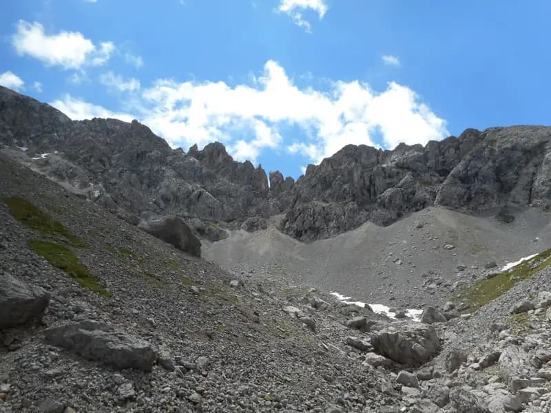
The starting point is at Malga Crocefisso (1522 m) in Val San Nicolò. If the road is passable, you can continue by car along the Val Monzoni road and park at the first hairpin turn; alternatively, use the malga parking lot. From here, take the paved trail (marker 603) that enters Val Monzoni, until a junction where you keep left following trail 641. The climb becomes steep in the woods, then opens up into an alpine environment, leading to Forcella dal Pief (2186 m), reached in about an hour and thirty minutes from the car. At the crossroads, turn right, tackling steep scree slopes: this is where the Gino Badia Trail (marker 640A) begins. The route skirts the western walls of Sass del Pief and Punta dell'Ort, entering a wide, wild valley that climbs toward the clearly visible Forcella dell'Ort. The first equipped sections appear after about two hours from the start of the walk, in a setting of solid rock and natural ledges that hint at the character of the itinerary.
Via Ferrata
The equipped sections of the Gino Badia Trail are not prohibitive, but they require attention due to the increasing exposure. Progression begins on rocky ramps and gullies, where support ropes assist on the steeper stretches heading toward the notch. The pace is sustained but steady, with some stirrups easing the bigger steps. The climb continues with the aid of fixed ropes for technically unchallenging passages, until reaching the iconic passage through the notch, a narrow fissure between two dolomite pinnacles, overcome in about thirty minutes from the start of the equipment. Beyond the notch, the view opens onto Passo delle Selles, the final destination. Following obvious tracks over mixed terrain, you gain Passo delle Selle in about forty minutes, for a total of roughly three hours and thirty minutes from the start. The itinerary alternates moments of easy scrambling with exposed walking on ledges, maintaining a predominantly scenic and physical character rather than a technical one.
Descent
From Passo delle Selle (2528 m), you have two options for returning to Malga Crocefisso. The simplest and recommended option is to take trail 604 heading west, which descends without difficulty over a wide scree slope to Rifugio Talamelli (2046 m, about 30 minutes). From the refuge, follow marker 603, which leads back to Malga Crocefisso in about an hour and thirty minutes from the pass, for a total of roughly five hours and thirty minutes. A longer and more demanding alternative, which significantly extends the route, involves traversing a section of the Alta Via Bepi Zac to Colle di Costabella (about 2 hours from Passo delle Selle). From here, descend left (marker 637) down a steep scree slope to Baita delle Cascate in Val San Nicolò (1 hour). From the hut, walk the entire Val San Nicolò to the junction for Malga Crocefisso (1 hour), for a total of six hours thirty minutes to seven hours. This variant requires good weather conditions and excellent fitness, presenting prolonged physical effort over varied terrain.
Useful Notes
The Gino Badia Via Ferrata is a overall demanding climb in terms of length and elevation gain, but has the advantage of being less crowded than other routes in the area. From a via ferrata perspective, it qualifies as an easy and scenic trail that, for experienced and fit hikers, can be combined with sections of the nearby Alta Via trails. From Passo delle Selle, other equipped routes can be undertaken: to the left (marker 637) the Alta Via Bepi Zac; heading southwest (marker 616) the Alta Via Bruno Federspiel in reverse direction. The area also offers other via ferratas such as the Ferrata Gadotti at Cima Aut, the Ferrata Magnifici 4, and the Ferrata Kaiserjäger at Col Ombert, allowing you to tailor the experience to your abilities and desire for exploration.
Track and weather
Plan the route
Preview the GPX track from the backend, download it for your GPS device, open parking directions, and check a short forecast before leaving.
Images
FAQ
What level of commitment does this via ferrata require?
ferrata.faqAnswers.commitment
How much elevation gain should I plan for?
The listed ferrata elevation gain is 1006 m. Also consider approach, return and maximum altitude, because they can matter more than the equipped section alone.
Where is the route located?
Sentiero Attrezzato Gino Badia is located in Dolomiti di Fassa, Trento, Italy. Before leaving, check parking, access and current local conditions.
When is the best time to climb it?
The best season depends on altitude, aspect and lingering snow. Avoid storms, wet rock and uncertain conditions; start early and keep a margin for the return.
Gear and safety planning
Use the technical data on this page to plan equipment, timing and offline navigation. For a general checklist, read the equipment guide before opening the route in the app.
Video
Watch the route
Useful YouTube videos for getting a real feel for the route before you go.
Logbook
Route condition reports
Recent community notes about closures, snow, equipment damage, trail issues and current conditions.
Community
Reviews, check-ins and photos
-
0 reviews
0
0 climbers
0
Shared by the community
Community photos
Recent images uploaded by Sferrati members.
No community photos yet
Open this route in the app to add the first photo.
Reviews
Recent impressions from climbers who know the route.
No reviews yet
Be the first to review this via ferrata from the app.
Continue in the app
Track the climb, save maps offline, and sync this route to your personal profile.
Use the app to climb
Offline maps, tracking, saves, and profile sync.
Scan the code before leaving, install the app, and keep your route data ready when reception fades.
