
Sentiero Attrezzato Guardiano
Monte Pelf · Belluno · Italy
Technical data
- Difficulty
- Moderatamente Difficile
- Status
- aperta
- Distance
- 22 km
- Total duration
- 11 h 30 min
- Approach
- 6 h 30 min
- Ferrata time
- 1 h 30 min
- Elevation gain
- 340 m
- Max altitude
- 2502 m
Route planning
How to plan Sentiero Attrezzato Guardiano
Sentiero Attrezzato Guardiano is in Monte Pelf, Belluno, Italy and is rated Moderatamente Difficile. Available route data lists about 11 h 30 min total time, 22 km of distance, 340 m of elevation gain.
For day planning, consider an approach of about 390 min, about 90 min on the cable, a maximum altitude near 2502 m. Reported route features include: Itinerario lungo, Itinerario Alpinistico.
The page includes a parking or driving-directions reference. A GPX track is not available yet, so bring an alternative map source.
As with every via ferrata, evaluate season, lingering snow, storms, crowds and equipment condition. Page last updated on 7/4/2026.
Features
Description
Overview
The Marino Guardiano Protected Path is a physically and technically demanding route, designed to reach the summit of Monte Pelf in the heart of the Schiara Group. The itinerary unfolds in two main parts: the first section consists of the ascent to Forcella Marmol via the Ferrata Piero Rossi, followed by the actual second protected section. While the technical difficulties on the protected passages are moderate, the overall setting is highly exposed, and the approach and descent trails demand constant concentration. The considerable length and total elevation gain suggest planning this route as a multi-day outing, making use of the available support points in the area.
Approach
Access begins from the village of Case Bortot (695 m) in the province of Belluno. From Belluno, take the road toward Col di Lana, then turn right toward Bolzano Bellunese and the Belluno Dolomites National Park. After passing Bolzano Bellunese and Gioz, follow signs for Rifugio Case Bortot to the end of the drivable road, where a large clearing serves as parking.
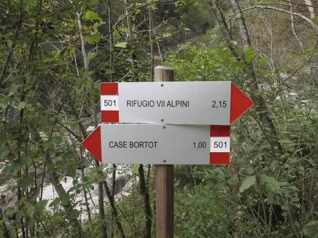
From here, the long approach begins. Take trail 501, which starts with a pleasant stretch through the woods and descends to the Ponte del Mariano (reached in about 30 minutes). After crossing the bridge, at a junction ignore trail 507 on the right (which will be used for the descent) and continue on trail 501. The climb becomes steeper, ascending the valley of the Ardo stream with a series of switchbacks, until emerging into the clearing of Rifugio VII Alpini (1502 m, reached in about 2 hours and 45 minutes from the parking lot).
To gain Forcella Marmol, the base of the Sentiero Guardiano, use the Ferrata Piero Rossi. From the rifugio, follow trail markers 503 north, passing through the distinctive Porton, to the start of the Ferrata Zacchi (reached in 45 minutes from the rifugio). Ascend the first common section of ferrata (about 100 meters) to a junction: here, leave the Zacchi by taking trail 514 to the right for the Ferrata Piero Rossi. The route continues upward, passes the Bivacco Bocco - Zago (2266 m), and ignores a left turn toward the summit of Schiara. The itinerary, alternating between protected sections and trail, finally leads to Forcella del Marmol (2262 m), reached in about 3 hours from the ferrata start (for a total of about 6 hours and 30 minutes from the parking lot).
Via Ferrata
From Forcella Marmol, the Marino Guardiano Protected Path begins. The first sector is the most vertical and technical: you immediately tackle some vertical passages and a traverse to the left, on compact rock with well-maintained equipment. After about fifteen minutes, the metal protections end, and you proceed on an exposed trail that develops eastward, staying just below the ridge on the north side (watch out for residual ice).
You then encounter a new short protected section that approaches the ridge, offering a magnificent view of the Schiara. The ascent toward the summit of Pelf continues, alternating between easy protected rock steps and an exposed ledge to the left. The final section is the most thrilling: a ridge itinerary, initially wide and unprotected, which then presents some airy protected passages. You climb to a gravelly saddle and, with the last meters on trail and rock steps, reach the summit of Monte Pelf (2502 m), marked by a wooden cross on a cairn. The travel time from Forcella Marmol is about 1 hour and 30 minutes, for a total of about 8 hours from the parking lot.
Descent
The descent follows the long normal route (trail markers 511). From the summit, follow the ridge eastward, immediately tackling a long and demanding section of descending rock steps that requires maximum attention. After this key passage, technical difficulties decrease, but attention must remain high to follow the trail, given the presence of sometimes faded and sporadic markings.
You lose elevation steadily until a junction: to the right, trail 505 leads to Rifugio VII Alpini, but continue left on trail 511 toward Mariano. The descent continues through meadows and then into the woods, passing by the dated Bivacco Casera Medassa (1342 m). Further on, you join trail 507, keeping right toward Ponte Mariano. After reaching the bridge, briefly climb back up on approach trail 501 to return to Case Bortot. The descent from the summit takes about 3 hours and 30 minutes, for a total hike time of about 11 hours and 30 minutes.
Useful Notes
The Marino Guardiano Protected Path has moderate technical difficulty on the protected sections, but should not be underestimated. It is a very long and physically demanding hike, with an approach that already includes a full via ferrata (the Piero Rossi). It is recommended only for experienced hikers and should be planned with stable weather, given the exposure and isolation of the environment. The presence of ice on north-facing slopes, even late in the season, is a risk to consider. The ideal approach is to split the ascent over two days, staying overnight at Rifugio VII Alpini or the Bivacco near Forcella Marmol.
The Schiara Group area lends itself to combining this itinerary with other challenging via ferratas such as the Zacchi, the Berti, or the Sperti, to create multi-day routes of an alpine character. For those seeking shorter and more accessible ferratas, a short distance away toward the Cadore region you'll find the Parete dei Falchi, the Palestra di Roccia della Val Gallina, and the Ferrata della Memoria al Vajont.
Track and weather
Plan the route
Preview the GPX track from the backend, download it for your GPS device, open parking directions, and check a short forecast before leaving.
GPX track unavailable
This route does not include a downloadable track yet.
Images
FAQ
What level of commitment does this via ferrata require?
ferrata.faqAnswers.commitment
How much elevation gain should I plan for?
The listed ferrata elevation gain is 340 m. Also consider approach, return and maximum altitude, because they can matter more than the equipped section alone.
Where is the route located?
Sentiero Attrezzato Guardiano is located in Monte Pelf, Belluno, Italy. Before leaving, check parking, access and current local conditions.
When is the best time to climb it?
The best season depends on altitude, aspect and lingering snow. Avoid storms, wet rock and uncertain conditions; start early and keep a margin for the return.
Gear and safety planning
Use the technical data on this page to plan equipment, timing and offline navigation. For a general checklist, read the equipment guide before opening the route in the app.
Video
Watch the route
Useful YouTube videos for getting a real feel for the route before you go.
Logbook
Route condition reports
Recent community notes about closures, snow, equipment damage, trail issues and current conditions.
Community
Reviews, check-ins and photos
-
0 reviews
0
0 climbers
0
Shared by the community
Community photos
Recent images uploaded by Sferrati members.
No community photos yet
Open this route in the app to add the first photo.
Reviews
Recent impressions from climbers who know the route.
No reviews yet
Be the first to review this via ferrata from the app.
Continue in the app
Track the climb, save maps offline, and sync this route to your personal profile.
Use the app to climb
Offline maps, tracking, saves, and profile sync.
Scan the code before leaving, install the app, and keep your route data ready when reception fades.
