
Sentieto Attrezzato dei Pizzetti
Prealpi Bergamasche · Lecco · Italy
Technical data
- Difficulty
- Facile
- Status
- aperta
- Distance
- 5,5 km
- Total duration
- 3 h 30 min
- Approach
- 45 min
- Ferrata time
- 1 h 45 min
- Elevation gain
- 325 m
- Max altitude
- 700 m
Route planning
How to plan Sentieto Attrezzato dei Pizzetti
Sentieto Attrezzato dei Pizzetti is in Prealpi Bergamasche, Lecco, Italy and is rated Facile. Available route data lists about 3 h 30 min total time, 5,5 km of distance, 325 m of elevation gain.
For day planning, consider an approach of about 45 min, about 105 min on the cable, a maximum altitude near 700 m.
The page includes a parking or driving-directions reference. A GPX track is not available yet, so bring an alternative map source.
As with every via ferrata, evaluate season, lingering snow, storms, crowds and equipment condition. Page last updated on 7/4/2026.
Description
Overview
The Sentiero Attrezzato dei Pizzetti remains one of the most rewarding and visually spectacular routes in the entire Lecco pre-Alps. While it requires no particular mountaineering technique, it features continuous protection on the steepest and most exposed sections, offering breathtaking views over the Lake Como basin. It is an ideal choice as an approach stage for combined ascents toward the peaks of San Martino, Medale, or Coltiglione.
Approach
The route begins from the locality of Rancio Alto, above Lecco. From the city, follow the road toward Ballabio up to a clear double hairpin turn in a residential area. At the second curve, continue straight onto Via Quarto. After about two hundred meters, near a clearing, take a steep paved lane on the right, marked by a rusty white barrier that is usually open. Climb this tight switchback, pass a first left-hand curve, and reach a fork where you keep right uphill. In a few minutes you arrive at a barrier where you can leave the car. The approach continues by climbing the paved road from the parking area to a hairpin turn, then leaving the roadway to proceed straight on an old mule track. After passing some rockfall nets and a service ladder, continue on the trail to a boulder with directions and a white sign for the Sentiero Attrezzato dei Pizzetti. Then take the path that climbs steeply through the woods, following the signs and a yellow marker at the next fork (keeping left). The ascent through the woods, on compact and well-trodden ground, offers the first glimpses of Lecco and the lake, reaching the actual start of the via ferrata in about 45 minutes from the parking area.
Via Ferrata
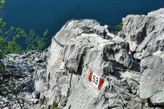
The route proper begins with the ascent of a not-difficult rocky gully, equipped with a few artificial steps. This first section, developed on compact limestone, introduces the typical morphology of the route. At its top you encounter a fork; both directions are passable, but the main route turns left toward the small gully that separates the two characteristic rocky spurs called "Pizzetti." This short section is equipped with chains and forms a chimney-gully to climb, aided by good natural holds and the steel cable. The environment changes radically upon exiting the gully: the route continues in a traverse at mid-height along a rather narrow ledge, carved into the wall, offering a magnificent view of the lake. The progression now alternates between airy walking sections and brief vertical passages. You pass around a boulder in a fairly exposed stretch, traverse an exposed horizontal section with good holds and foot stirrups, and advance along an airy but not difficult path. The pace is continuous, with constant exposure that enhances the panoramic character of the route. The last equipped passage consists of the descent of a vertical rocky spur, after which the main technical difficulties are considered over. The trail continues with ups and downs to a final series of chains on a sloping section that can become slippery after heavy rain. From here, the path re-enters the woods and, with a final climb, leads to the Rifugio Piazza, the endpoint. The climbing time is about 1 hour and 45 minutes from the start of the via ferrata, for a total of 2 hours and 30 minutes from the departure point.
Descent
The descent can be made via the same Sentiero Attrezzato dei Pizzetti, taking about 1 hour and 30 minutes from the refuge (total 3 hours and 30 minutes). Alternatively, you can continue from Rifugio Piazza toward Monte San Martino and choose between two variants: descend the Sentiero Attrezzato Silvia to the Madonnina del Carmine and then the Sentiero Attrezzato della Vergella toward Rancio, or head toward Medale and descend via the Sentiero Attrezzato del Medale. Both of these options take about 2 hours and 30 minutes of descent from the refuge, for a total of 4 hours and 30 minutes.
Useful Notes
The Sentiero Attrezzato dei Pizzetti is famous for its exceptional panorama and for the balance between moderate technical difficulty and a highly impressive landscape setting. Given its low altitude and predominantly east and south exposure, during the summer months the route is often sun-baked for many hours. It is therefore essential to bring an ample supply of water. The route lends itself perfectly to being linked with other equipped descent routes. A longer and more challenging variant involves descending it after tackling the Ferrata al Corno Medale, for a loop tour lasting a total of about 6 hours and 30 minutes.
Track and weather
Plan the route
Preview the GPX track from the backend, download it for your GPS device, open parking directions, and check a short forecast before leaving.
GPX track unavailable
This route does not include a downloadable track yet.
Images
FAQ
What level of commitment does this via ferrata require?
ferrata.faqAnswers.commitment
How much elevation gain should I plan for?
The listed ferrata elevation gain is 325 m. Also consider approach, return and maximum altitude, because they can matter more than the equipped section alone.
Where is the route located?
Sentieto Attrezzato dei Pizzetti is located in Prealpi Bergamasche, Lecco, Italy. Before leaving, check parking, access and current local conditions.
When is the best time to climb it?
The best season depends on altitude, aspect and lingering snow. Avoid storms, wet rock and uncertain conditions; start early and keep a margin for the return.
Gear and safety planning
Use the technical data on this page to plan equipment, timing and offline navigation. For a general checklist, read the equipment guide before opening the route in the app.
Video
Watch the route
Useful YouTube videos for getting a real feel for the route before you go.
Logbook
Route condition reports
Recent community notes about closures, snow, equipment damage, trail issues and current conditions.
Community
Reviews, check-ins and photos
-
0 reviews
0
0 climbers
0
Shared by the community
Community photos
Recent images uploaded by Sferrati members.
No community photos yet
Open this route in the app to add the first photo.
Reviews
Recent impressions from climbers who know the route.
No reviews yet
Be the first to review this via ferrata from the app.
Continue in the app
Track the climb, save maps offline, and sync this route to your personal profile.
Use the app to climb
Offline maps, tracking, saves, and profile sync.
Scan the code before leaving, install the app, and keep your route data ready when reception fades.
