
Sentieto Attrezzato Filippo Benedetti
Punta Almana · Brescia · Italy
Technical data
- Difficulty
- Facile
- Status
- aperta
- Distance
- 8,2 km
- Total duration
- 3 h 45 min
- Approach
- 1 h 15 min
- Ferrata time
- 1 h
- Elevation gain
- 372 m
- Max altitude
- 1390 m
Route planning
How to plan Sentieto Attrezzato Filippo Benedetti
Sentieto Attrezzato Filippo Benedetti is in Punta Almana, Brescia, Italy and is rated Facile. Available route data lists about 3 h 45 min total time, 8,2 km of distance, 372 m of elevation gain.
For day planning, consider an approach of about 75 min, about 60 min on the cable, a maximum altitude near 1390 m.
The page includes a parking or driving-directions reference. A GPX track is available to review and download.
As with every via ferrata, evaluate season, lingering snow, storms, crowds and equipment condition. Page last updated on 7/4/2026.
Description
Overview
The Sentiero Attrezzato Filippo Benedetti is a highly rewarding hiking route, featuring short protected sections that lead to the panoramic summit of Punta Almana, which dominates Lake Iseo in the province of Brescia. The route presents no significant mountaineering difficulties and, thanks to its moderate elevation gain, can be comfortably completed in half a day. The itinerary unfolds along a pre-alpine ridge, alternating grassy stretches with rocky slabs and ledges, offering a continuous and never monotonous experience with sweeping views over the Sebino amphitheater and the surrounding peaks.
Approach
The starting point is the locality of Portole, above Presso, on the eastern shore of Lake Iseo. From the main road, turn off at Presso to take a narrow dirt road that, with a series of switchbacks, leads near the Ristorante Portole, where there is ample parking. The hike begins here. Follow the obvious uphill path that heads toward Punta Almana. The trail can be done in either direction; this description follows the route from north (Forcella di Sale) to south (Croce di Pezzolo). From the parking area, continue along the dirt road heading northeast, with a steady but never excessive gradient, until reaching Forcella di Sale in about an hour, an important junction in the trail network. Here, leave the dirt road and follow the signs for trail 3V / 314, which enters the woods for a few meters to a fork. Turning right, you begin the actual Sentiero Attrezzato Benedetti (about 1 hour and 15 minutes from the parking lot). The approach takes place in a mid-mountain environment, through meadows and clearings, with a steady rhythm that gradually prepares you for the effort ahead.
Via Ferrata
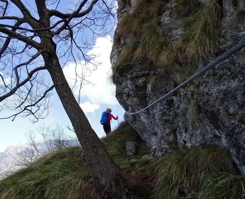
The route begins with a steep climb through the meadows, marked by white-and-blue trail markers. Ascend several steep grassy slopes, heading toward a rocky saddle that is reached in a few minutes, arriving at the sub-summit of Punta Cabrera. Be careful on this section if the ground is wet, due to the tall grass and potentially slippery terrain. Shortly after, you encounter the first protected section: an easy diagonal ledge, developed on compact limestone. The only difficulty may be the grassy and earthy surface, which requires caution in damp conditions. The route continues by climbing a grassy gully southward to Punta Cabrera, a physically demanding but technically simple stretch. After a short descent, you tackle a more exposed traverse along an airy ledge, where the steel cable provides the necessary security. The third and most interesting protected section is the ascent of a rocky gully, with slabs and small steps; experienced hikers can climb directly on the rock without necessarily using the cable, appreciating the solidity of the rock. Once past this gully, the protected sections end (about 30 minutes from the start of the ferrata; 1 hour and 45 minutes total from the parking lot). You are now on the ridge, with the summit cross of Punta Almana clearly visible in the distance. Continue along a broad and never difficult ridge trail, a series of ups and downs that keep the interest alive, finally reaching the panoramic summit in about another 30 minutes (for a total of about 2 hours and 15 minutes). The pace of the itinerary is lively, with a succession of short but significant technical passages, interspersed with more relaxed walking along the ridge.
Descent
From the summit of Punta Almana, descend southward along the ridge trail of Dosso Pelato, broad and not difficult, until reaching the Croce di Pezzuolo. This descent section offers an airy and scenic walk, with continuous views over Val Cavallina. At this crossroads, keep right, descending until you intercept a dirt road. The suggestion is to keep left for a few minutes, until a fork (pay attention) where a trail descends to the right toward Locasso. Taking this, you encounter another dirt road that, descending, leads back to the Ristorante Portole. The descent from the summit takes about 1 hour and 15 minutes, for a total hike time of about 3 hours and 45 minutes. The return takes place in a more wooded and sheltered environment, with a straightforward route and no technical difficulties, ideal for concluding the loop in tranquility.
Useful Notes
The Sentiero Attrezzato Benedetti on Punta Almana can be done in either direction. The north-to-south direction described here is considered easier, as it tackles the protected sections while ascending, making the most of natural progression. If doing the route in the opposite direction (south-to-north), extra caution is needed on the section between Punta Almana and Forcella di Sale, which features several exposed and potentially slippery points, as well as the protected sections themselves, which require more control when descending. For maps, a detailed map of the Lake Iseo area is recommended. The itinerary is a pleasant hike in the Brescian Prealps, suitable for combining on the same day with other nearby via ferratas with short approaches, such as the Ferrata Fregio, the Ferrata delle Ginestre, the Ferrata Crench, or the Sentiero Attrezzato Sasse. In the broader Lake Iseo and Brescia province area, for those seeking longer routes, options include the Ferrata al Corno del Bene, the Sentiero Attrezzato Trentapassi, or the Ferrata al Pizzo Badile Camuno. The route is characterized by its accessibility and morphological variety, blending moments of technical challenge with long stretches of classic hiking in a balanced way, all immersed in an open and panoramic environment.
Track and weather
Plan the route
Preview the GPX track from the backend, download it for your GPS device, open parking directions, and check a short forecast before leaving.
Images
FAQ
What level of commitment does this via ferrata require?
ferrata.faqAnswers.commitment
How much elevation gain should I plan for?
The listed ferrata elevation gain is 372 m. Also consider approach, return and maximum altitude, because they can matter more than the equipped section alone.
Where is the route located?
Sentieto Attrezzato Filippo Benedetti is located in Punta Almana, Brescia, Italy. Before leaving, check parking, access and current local conditions.
When is the best time to climb it?
The best season depends on altitude, aspect and lingering snow. Avoid storms, wet rock and uncertain conditions; start early and keep a margin for the return.
Gear and safety planning
Use the technical data on this page to plan equipment, timing and offline navigation. For a general checklist, read the equipment guide before opening the route in the app.
Video
Watch the route
Useful YouTube videos for getting a real feel for the route before you go.
Logbook
Route condition reports
Recent community notes about closures, snow, equipment damage, trail issues and current conditions.
Community
Reviews, check-ins and photos
-
0 reviews
0
0 climbers
0
Shared by the community
Community photos
Recent images uploaded by Sferrati members.
No community photos yet
Open this route in the app to add the first photo.
Reviews
Recent impressions from climbers who know the route.
No reviews yet
Be the first to review this via ferrata from the app.
Continue in the app
Track the climb, save maps offline, and sync this route to your personal profile.
Use the app to climb
Offline maps, tracking, saves, and profile sync.
Scan the code before leaving, install the app, and keep your route data ready when reception fades.
