
Via Ferrata degli Alcaresi
Rocca Traura · Messina · Italy
Technical data
Open- Difficulty
- Moderately Difficult
- Total duration
- 2 h 30 min
- Distance
- 3 km
- Elevation gain
- 450 m
Times and altitude
- Approach
- 30 min
- Ferrata time
- 1 h 30 min
- Max altitude
- 1000 m
Description
Overview
The Via Ferrata degli Alcaresi follows the rocky walls of Rocca Traura, an imposing limestone formation rising above the village of Alcara Li Fusi, in the western Nebrodi Mountains. The route crosses one of the most distinctive environments of the Rocche del Crasto, combining rock faces, exposed ridges, gullies and panoramic sections overlooking the Tyrrhenian coast.
The itinerary is divided into two separate sections. The first, known as Sector A, climbs from the Madonna delle Grazie area to the upper part of Rocca Traura and must only be followed uphill. Sector B continues from the summit area towards Contrada Baratta, mainly descending from the mountain and also allowing travel in the opposite direction.
The technical grading of the route is not entirely consistent. The overall difficulty is generally indicated as “Moderately Difficult”, while more conservative assessments rate Sector A as “Very Difficult” and Sector B as “Difficult”. The combination of vertical passages, exposed sections and protected stretches that must also be negotiated while descending makes the route more suitable for hikers who already have some experience on via ferratas.
The equipped route gains approximately 450 m of elevation, while the total elevation gain for the complete itinerary can reach around 600 m when the approach and connecting sections are included. The entire route is approximately 3 km long, with around 30 minutes for the approach, 1h 30' on the equipped sections and an overall duration of approximately 2h 30'. From the upper slopes of Rocca Traura, the panorama extends across the Nebrodi Mountains, the Tyrrhenian Sea and, on particularly clear days, the Aeolian Islands.
Approach
The main reference point for reaching the via ferrata is the Madonna delle Grazie area, located just outside Alcara Li Fusi. From the village, follow the road towards the sports field and continue beyond the facilities until reaching an area where the car can be parked. The limestone walls of Rocca Traura are already clearly visible from the parking area.
From here, follow the trail leading towards the base of the mountain and the signs for the via ferrata. The path gradually gains elevation through vegetation and rocky terrain until reaching the beginning of the equipped route. Approximately 30 minutes are required to reach the starting point.
The approach already provides a good introduction to the landscape of the Rocche del Crasto, characterised by steep limestone walls, rugged peaks and deep gullies cutting through the slopes. The area is also particularly important from a naturalistic point of view due to the presence of the griffon vulture, which has once again established nesting sites on the cliffs of the Nebrodi Mountains.
Via Ferrata
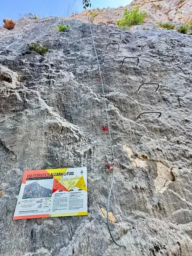
Sector A forms the main ascent towards Rocca Traura. The equipment begins at approximately 550 m above sea level with a fairly vertical wall assisted by metal rungs. After the first rocky step, a short lateral section leads quickly to another vertical passage.
The opening section gains elevation rapidly and is one of the first places where the exposure of the route becomes clearly noticeable. Beyond these steeper passages, the terrain gradually becomes more varied, alternating rocky sections, short protected passages and easier stretches that resemble an equipped hiking trail.
Vegetation accompanies part of the ascent and can become particularly dense at certain times of the year, occasionally making the route less obvious. Continuing upwards, the trail eventually reaches the ridge at approximately 870 m above sea level, where the surroundings become increasingly open and panoramic.
From the ridge, the summit cross becomes visible. The equipment continues along the profile of the mountain, alternating exposed passages with short sections on natural terrain before reaching the upper part of Rocca Traura. A final short stretch leads to the summit cross, located at approximately 1,000 m above sea level.
The summit is one of the most panoramic points of the entire route. Views extend across the surrounding mountains and the valley of Alcara Li Fusi, while to the north the landscape opens towards the Tyrrhenian coast. In good visibility, the Aeolian Islands can also be seen on the horizon.
Sector A must only be climbed upwards. The combination of vertical terrain and exposure requires good familiarity with progression on a safety cable and makes this section noticeably more demanding than an introductory via ferrata.
Sector B begins from the summit area. The first section follows a trail through rocks and natural terrain, with route markers helping to identify the correct direction. After initially losing some elevation, the path reaches the entrance to a gully, where the fixed equipment becomes more continuous.
The descent alternates between safety cable, rocky passages and short sections of trail. Some sections remain exposed, meaning the via ferrata set must continue to be used even after reaching the summit. Helmet, harness and via ferrata lanyard should therefore remain in place until the equipped sections have completely finished.
Compared with Sector A, the terrain is generally less vertical, although negotiating the protected passages downhill can be less intuitive for hikers with limited experience. Beyond the gully, several additional short equipped sections are encountered, separated by stretches of natural terrain, before the safety cable finally comes to an end.
Sector B can also be travelled in the opposite direction, allowing it to be used as an independent ascent followed by a return along the same route. Approximately 1h 30' should be allowed to complete both equipped sectors.
Descent
At the end of Sector B, the fixed equipment is left behind and the route continues across considerably easier terrain. The return follows a dirt road, gradually completing the loop and leading back towards the starting area.
From the end of the equipped section, approximately 20-30 minutes are required to return to the parking area. Including the approach, via ferrata and descent, the complete outing takes approximately 2h 30', although times can vary according to experience and the number of people on the route.
It is important to remember that Sector A must not be descended. Anyone completing the full itinerary must therefore continue to the summit of Rocca Traura and use Sector B as the natural route back down towards the valley.
Notes
The Via Ferrata degli Alcaresi crosses an area of significant environmental value within the Nebrodi Mountains. The cliffs of the Rocche del Crasto are home to a stable colony of griffon vultures, which returned to this part of Sicily following a successful reintroduction programme.
The presence of nesting sites may result in seasonal access restrictions. Before setting out, it is therefore advisable to check for temporary closures, local regulations or other restrictions affecting access to the via ferrata.
The route is intended for experienced hikers equipped for via ferrata. A helmet, harness and certified via ferrata set are essential, while gloves are recommended for greater comfort when handling the safety cable.
Despite its relatively limited length, the combination of vertical terrain, exposure and an equipped descent requires more experience than a beginner-level via ferrata. Particular attention should also be paid to weather conditions, as the ridge and upper sections of Rocca Traura are especially exposed.
The via ferrata was also created to enhance the outdoor appeal of Alcara Li Fusi and expand the range of hiking opportunities available in the Nebrodi Mountains, offering the chance to experience the Rocche del Crasto from a much more vertical perspective than the area's traditional hiking trails.
Features
Track and weather
Plan the route
Preview and download the GPX track, open parking directions, and check a short forecast before leaving.
Images
Gear and safety planning
Use the technical data on this page to plan equipment, timing and offline navigation. For a general checklist, read the equipment guide before opening the route in the app.
Video
Watch the route
Useful YouTube videos for getting a real feel for the route before you go.
Logbook
Route condition reports
Recent community notes about closures, snow, equipment damage, trail issues and current conditions.
Community
Reviews, check-ins and photos
-
0 reviews
0
0 climbers
0
Shared by the community
Community photos
Recent images uploaded by Sferrati members.
No community photos yet
Open this route in the app to add the first photo.
Reviews
Recent impressions from climbers who know the route.
No reviews yet
Be the first to review this via ferrata from the app.
Continue in the app
Track the climb, save maps offline, and sync this route to your personal profile.
Use the app to climb
Offline maps, tracking, saves, and profile sync.
Scan the code before leaving, install the app, and keep your route data ready when reception fades.