
Ferrata Dibona al Cristallo
Gruppo del Cristallo · Belluno · Italy
Technical data
- Difficulty
- Moderatamente Difficile
- Status
- aperta
- Distance
- 23 km
- Total duration
- 10 h
- Approach
- 2 h 15 min
- Ferrata time
- 5 h
- Elevation gain
- 1300 m
- Max altitude
- 3008 m
Route planning
How to plan Ferrata Dibona al Cristallo
Ferrata Dibona al Cristallo is in Gruppo del Cristallo, Belluno, Italy and is rated Moderatamente Difficile. Available route data lists about 10 h total time, 23 km of distance, 1300 m of elevation gain.
For day planning, consider an approach of about 135 min, about 300 min on the cable, a maximum altitude near 3008 m. Reported route features include: Ponti sospesi, Interesse Storico, Funivia al ritorno, Funivia all'andata.
The page includes a parking or driving-directions reference. A GPX track is available to review and download.
As with every via ferrata, evaluate season, lingering snow, storms, crowds and equipment condition. Page last updated on 7/4/2026.
Features
Description
Overview
The Ivano Dibona Via Ferrata is a classic ridgeline route through the Cristallo Group, combining remarkable historical significance with world-class panoramic scenery. The trail runs from Forcella Staunies to Col de Strombi, offering a succession of breathtaking viewpoints and touching numerous remnants of the Great War. While it does not present extreme technical difficulties, the route includes several exposed sections and demands excellent physical fitness due to the total elevation gain and sustained commitment.
Approach
The logical starting point is the parking area at the Ristorante Rio Gere, along the state road that climbs from Cortina d'Ampezzo toward Passo delle Tre Croci. From here, using the chairlift that connects Rio Gere (1700 m) to Rifugio Son Forca (2215 m) is strongly recommended. To reach the start of the via ferrata at Forcella Staunies (2932 m), you must ascend the steep Gran Stounies debris gully, a loose, gravelly channel that requires careful foot placement. Given the temporary absence of the historic cable car, now dismantled, the hike on foot from Son Forca takes no less than two hours of walking over uneven, consistently steep terrain.
Via Ferrata
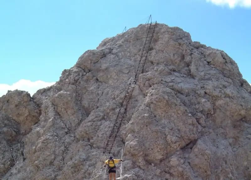
Once at Forcella Staunies and the panoramic Rifugio Lorenzi (currently not operational), the Ferrata Dibona begins with a sturdy metal ladder anchored to the rock. This first section is the most physically demanding, featuring a ledge, a wooden walkway, and short ups and downs over rocky outcrops. You pass through a modest-length war tunnel before traversing a comfortable equipped ledge. The route continues toward one of its iconic features: the suspension bridge, about 30 meters long, wide, and built with wooden sleepers. After crossing the bridge, a long metal ladder allows you to gain the main ridge, which is well equipped with cable and rungs.
Just beyond, at a marked junction at 2980 m, you can take the optional detour to Cima Cristallino (3008 m), which requires about 40 minutes round trip. Returning to the main route, you descend with easy passages toward Forcella Grande (2874 m), where the trail for the Ferrata Renè de Pol branches off. In this sector, the first ruins of Great War positions appear. Keeping left, the route continues along the left side of the Cristallo, skirting the remains of a former Italian military shelter.
The trail, composed of ledges, traverses, and equipped walkways, leads to Forcella Padeon and the Bivacco Buffa di Perrero, a former barracks renovated in an extremely panoramic position. The following section, which develops on the south side of Vecio del Forame, features exposed ledges that are partly unprotected, requiring good comfort with exposure. You then descend through a long equipped gully to Forcella Alta and a junction at 2490 m. Here, the left-hand detour toward Val Padeon constitutes a difficult escape route not recommended under normal conditions.
Continuing straight on the Sentiero Dibona, you reach Forcella Bassa and, after an unequipped mid-slope section along the Cresta dello Zurlon, encounter more military ruins. A steep, uneven descent down a gravelly gully finally brings you to Col dei Stombi (2017 m), where the proper rocky environment ends. The final segment descends steeply until it joins the forest trail CAI 203 at 1700 m.
Descent
From the junction with trail 203, keeping left leads to Passo Son Forcia (2109 m). From here, you can climb to Rifugio San Forcia to take the chairlift back to Rio Gere, being sure to check the operating hours. Alternatively, continuing on trail 203 and then turning left onto the CAI 206 trail toward Malga Lareto, you find an unmarked track that descends directly to Rio Gere, thus completing the loop.
Useful Notes
The itinerary has historically been done as a descent, but with the cable car inactive and Rifugio Lorenzi closed, planning must account for the lack of intermediate support points, except for the Bivacco Buffa di Perrero. The unequipped sections are simple but exposed, while the intermediate escape route should be considered only for emergencies. Given the length and sustained effort, excellent physical preparation, proper equipment, and consultation of specific area maps are essential. The route, rich in history, is named after Ivano Dibona and boasts the longest suspension bridge in the Dolomites, also famous for appearing in the film Cliffhanger.
Track and weather
Plan the route
Preview the GPX track from the backend, download it for your GPS device, open parking directions, and check a short forecast before leaving.
Images
FAQ
What level of commitment does this via ferrata require?
ferrata.faqAnswers.commitment
How much elevation gain should I plan for?
The listed ferrata elevation gain is 1300 m. Also consider approach, return and maximum altitude, because they can matter more than the equipped section alone.
Where is the route located?
Ferrata Dibona al Cristallo is located in Gruppo del Cristallo, Belluno, Italy. Before leaving, check parking, access and current local conditions.
When is the best time to climb it?
The best season depends on altitude, aspect and lingering snow. Avoid storms, wet rock and uncertain conditions; start early and keep a margin for the return.
Gear and safety planning
Use the technical data on this page to plan equipment, timing and offline navigation. For a general checklist, read the equipment guide before opening the route in the app.
Video
Watch the route
Useful YouTube videos for getting a real feel for the route before you go.
Logbook
Route condition reports
Recent community notes about closures, snow, equipment damage, trail issues and current conditions.
Community
Reviews, check-ins and photos
-
0 reviews
2
2 climbers
0
Shared by the community
Community photos
Recent images uploaded by Sferrati members.
No community photos yet
Open this route in the app to add the first photo.
Reviews
Recent impressions from climbers who know the route.
No reviews yet
Be the first to review this via ferrata from the app.
Continue in the app
Track the climb, save maps offline, and sync this route to your personal profile.
Use the app to climb
Offline maps, tracking, saves, and profile sync.
Scan the code before leaving, install the app, and keep your route data ready when reception fades.
