
Technical data
- Difficulty
- Moderatamente Difficile
- Status
- aperta
- Distance
- 1 km
- Total duration
- 45 min
- Approach
- 5 min
- Ferrata time
- 30 min
- Elevation gain
- 90 m
- Max altitude
- 635 m
Route planning
How to plan Ferrata Mahr
Ferrata Mahr is in Alpi Noriche, Bolzano, Italy and is rated Moderatamente Difficile. Available route data lists about 45 min total time, 1 km of distance, 90 m of elevation gain.
For day planning, consider an approach of about 5 min, about 30 min on the cable, a maximum altitude near 635 m. Reported route features include: Avvicinamento corto.
The page includes a parking or driving-directions reference. A GPX track is available to review and download.
As with every via ferrata, evaluate season, lingering snow, storms, crowds and equipment condition. Page last updated on 7/4/2026.
Features
Description
Overview
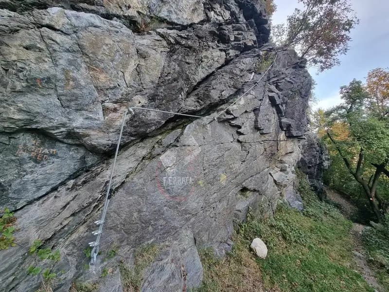
Opened in 2022, this modest-length via ferrata unfolds across the cliffs of the Mahr crag, south of Bressanone. The route is laid out as a loop offering two different climbing options: a difficult variant and one of moderate difficulty, ideal for focused technical training. The terrain is typically vertical, with a line that exploits the features of the limestone wall, delivering a concentrated and technical experience.
Approach
The route begins from the parking area in the locality of Mahr (La Marra), located south of Bressanone along a road parallel to the A22 Brennero motorway. From the parking lot, walk for about five minutes heading south, where the imposing cliff face looms immediately to the right. After passing a side road, you'll spot a signpost with the white-and-red CAI trail markers; following the path quickly brings you to the start of the ferrata at the base of the rock. The approach is short and leads directly into the heart of the rocky environment.
Via Ferrata
The ferrata is laid out in a figure-eight pattern, a well-structured loop. The lower initial section on the left side is the most demanding part of the entire route, characterized by a technical and athletic traverse that moves predominantly to the right over compact rock. The lower right-hand variant is easier, featuring only a couple of moderately difficult moves across more open slabs. Both base routes converge at mid-height, beneath a pronounced vertical dihedral that marks a pause in the progression. The upper part of the loop in turn offers a fork. The right side of the upper route is more difficult, with vertical progressions and a short overhanging section that demands arm strength. The left side of the upper route maintains a moderate difficulty, running along a wider ledge and being more accessible. The pace is therefore adjustable, alternating phases of concentrated technical effort with stretches of smoother progression, all while constant exposure ensures broad panoramic views.
Descent
The descent is made by retracing one of the two via ferrata routes. It stands to reason that if you have enough energy to tackle the difficult variants on the ascent, the moderate sections of the loop can be comfortably used as a descent route, offering a more relaxed and controlled return. This choice allows you to vary the experience and manage any remaining fatigue.
Useful Notes
This is a short ferrata that is intense, perfect for a technical training session or for getting comfortable with your gear in a protected yet stimulating environment. The character is predominantly vertical and athletic, with moves that require good strength management. For orientation and trip planning in the Bressanone area, it is advisable to consult a detailed map of the region, such as the one dedicated to Val Gardena, Val di Funes, and the Alpe di Siusi.
Track and weather
Plan the route
Preview the GPX track from the backend, download it for your GPS device, open parking directions, and check a short forecast before leaving.
Images
FAQ
What level of commitment does this via ferrata require?
ferrata.faqAnswers.commitment
How much elevation gain should I plan for?
The listed ferrata elevation gain is 90 m. Also consider approach, return and maximum altitude, because they can matter more than the equipped section alone.
Where is the route located?
Ferrata Mahr is located in Alpi Noriche, Bolzano, Italy. Before leaving, check parking, access and current local conditions.
When is the best time to climb it?
The best season depends on altitude, aspect and lingering snow. Avoid storms, wet rock and uncertain conditions; start early and keep a margin for the return.
Gear and safety planning
Use the technical data on this page to plan equipment, timing and offline navigation. For a general checklist, read the equipment guide before opening the route in the app.
Video
Watch the route
Useful YouTube videos for getting a real feel for the route before you go.
Logbook
Route condition reports
Recent community notes about closures, snow, equipment damage, trail issues and current conditions.
Community
Reviews, check-ins and photos
-
0 reviews
0
0 climbers
0
Shared by the community
Community photos
Recent images uploaded by Sferrati members.
No community photos yet
Open this route in the app to add the first photo.
Reviews
Recent impressions from climbers who know the route.
No reviews yet
Be the first to review this via ferrata from the app.
Continue in the app
Track the climb, save maps offline, and sync this route to your personal profile.
Use the app to climb
Offline maps, tracking, saves, and profile sync.
Scan the code before leaving, install the app, and keep your route data ready when reception fades.
