
fabione35
Apr 6, 2026
Ferrata breve ma da non sottov...
Ferrata breve ma da non sottovalutare, tutto comodo parcheggio,avvicinamento e rientro.
ModerataVistaParcheggioAvvicinamentoRientroEsposizione

Alpi Graie · Torino · Italy
Route planning
Ferrata Orrido di Chianocco is in Alpi Graie, Torino, Italy and is rated Moderatamente Difficile. Available route data lists about 1 h 30 min total time, 4 km of distance, 90 m of elevation gain.
For day planning, consider an approach of about 15 min, about 45 min on the cable, a maximum altitude near 614 m. Reported route features include: Ponti sospesi, Avvicinamento corto.
The page includes a parking or driving-directions reference. A GPX track is available to review and download.
As with every via ferrata, evaluate season, lingering snow, storms, crowds and equipment condition. Page last updated on 7/4/2026.
The Ferrata dell'Orrido di Chianocco winds through the spectacular gorge carved by the Prebec stream in Val di Susa, right next to the village of the same name. The route demands no particular technical skills, offering an accessible and enjoyable experience marked by a few exposed sections on vertical and slightly overhanging walls. Its main appeal lies in the unique setting: climbing up the narrow, deep ravine, with its striking views and deep immersion in the local landscape, makes this route especially rewarding from a scenic standpoint.
The starting point is the hamlet of Chianocco, in the municipality of Bussoleno. It's best to leave your car near the church. From here, a trail marked with red-and-white blazes branches off to the right, passes an information panel, and heads toward the Prebec gorge. The approach continues through dense woods, crosses a short natural tunnel, and requires a couple of easy stream crossings. In about 15 minutes from the parking area, you reach the first short equipped sections, which serve as an introduction to the actual via ferrata.
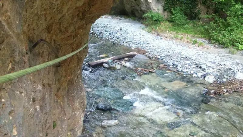
The first few meters on rock, fitted with a cable and steps, act as a warm-up and lead to the true start of the ferrata. The route begins with a fairly comfortable horizontal traverse, just a few meters above the streambed. It then takes on a diagonal line and becomes more challenging, passing through a cleft and climbing up an edge to reach another traverse that soon brings you to the suspended footbridge. The crossing is stable, thanks to a double cable that provides foot support.
Beyond the bridge, a traverse equipped with stirrups leads to a vertical and slightly overhanging wall. This section is easily manageable thanks to the many metal steps set into a crack in the rock, allowing for a quick gain in height and exposure. The most characteristic stretch follows shortly after: a long, exposed, and slightly overhanging traverse that requires some care. After about twenty meters, the route dips downhill, becoming less demanding, crosses a barrier on the stream, and skirts a small grove. Here you can approach the bank to observe the distinctive hole of a dam. The ferrata ends after a final ten-minute stretch of rocky steps and an equipped trail. The via ferrata itself takes about 45 minutes, for a total of roughly one hour including the approach.
The return follows well-marked trails with the classic red-and-white blazes. In about 20 minutes, you're back in the village and at the parking area, for a total hike time of around two hours, including breaks.
The Ferrata dell'Orrido di Chianocco presents no high technical difficulties, but the overhanging sections can be tiring on the arms. It's a good idea to check the flow of the Prebec stream before heading out, though direct contact with the water is essentially limited to the stream crossings on the approach. Its location in Val di Susa makes it ideal for pairing with other nearby ferratas, such as the Ruceia, Carlo Giorda at Pirchiarano, or those at Foresto, Claviere, and Bardonecchia.
Track and weather
Preview the GPX track from the backend, download it for your GPS device, open parking directions, and check a short forecast before leaving.
ferrata.faqAnswers.commitment
The listed ferrata elevation gain is 90 m. Also consider approach, return and maximum altitude, because they can matter more than the equipped section alone.
Ferrata Orrido di Chianocco is located in Alpi Graie, Torino, Italy. Before leaving, check parking, access and current local conditions.
The best season depends on altitude, aspect and lingering snow. Avoid storms, wet rock and uncertain conditions; start early and keep a margin for the return.
Use the technical data on this page to plan equipment, timing and offline navigation. For a general checklist, read the equipment guide before opening the route in the app.
Video
Useful YouTube videos for getting a real feel for the route before you go.
Logbook
Recent community notes about closures, snow, equipment damage, trail issues and current conditions.
Community
4.3
3 reviews
2
2 climbers
10
Shared by the community
Recent images uploaded by Sferrati members.
Recent impressions from climbers who know the route.
Apr 6, 2026
Ferrata breve ma da non sottovalutare, tutto comodo parcheggio,avvicinamento e rientro.

Mar 26, 2026
Percorso molto corto, ma da non sottovalutare. In questa piccola ferrata c’è tutto! Ponte tibetano, sezioni in strapiombo traversi ecc… Si svolge in poco tempo ma per un riscaldamento magari quando si ha poca tempo è perfetta!

Feb 7, 2026
Ferrata carina ma molto molto breve, da fare per riscaldamento. Il sentiero di avvicinamento e’ meraviglioso mentre quello di ritorno (anche bellissimo) è poco segnalato, io e il mio compagno di avventura ci siamo persi ma le persone del posto (super gentili) telefonicamente ci hanno indicato pian piano la via del ritorno. Un grazie speciale al sindaco di Chianocco che ci ha supportato per ritrovare la “retta via”.
Track the climb, save maps offline, and sync this route to your personal profile.
Use the app to climb
Scan the code before leaving, install the app, and keep your route data ready when reception fades.
