
Technical data
- Difficulty
- Moderatamente Difficile
- Status
- aperta
- Distance
- 1,4 km
- Total duration
- 3 h
- Approach
- 5 min
- Ferrata time
- 2 h 40 min
- Elevation gain
- 125 m
- Max altitude
- 1500 m
Route planning
How to plan Ferrata del Rouas
Ferrata del Rouas is in Alpi Graie, Torino, Italy and is rated Moderatamente Difficile. Available route data lists about 3 h total time, 1,4 km of distance, 125 m of elevation gain.
For day planning, consider an approach of about 5 min, about 160 min on the cable, a maximum altitude near 1500 m. Reported route features include: Ponti sospesi, Avvicinamento corto.
The page includes a parking or driving-directions reference. A GPX track is available to review and download.
As with every via ferrata, evaluate season, lingering snow, storms, crowds and equipment condition. Page last updated on 7/4/2026.
Features
Description
Overview
The Ferrata del Rouas is a recently installed route in the upper Val di Susa, right on the French border. The itinerary has a decidedly athletic character, with a variant B that demands considerable physical and technical commitment. The main route, excluding this deviation, is also suitable for a first approach to the activity, provided you have complete and well-maintained equipment. The via ferrata unfolds across a compact wall, shaping a route that alternates vertical sections with long traverses on ledges, offering a varied and continuous progression.
Approach
The route starts from the hamlet of Melezet in the municipality of Bardonecchia (TO). After crossing the village, proceed for about three hundred meters along the SP216. The access is marked by a satellite dish of a repeater; immediately after, you'll find a parking area with the relevant information board. From the parking lot, a very short trail leads in just over five minutes to the base of the wall, where the itinerary dedicated to Bompard and Perona begins. The quick approach and the already alpine setting immediately introduce the character of the climb.
Via Ferrata
The itinerary is divided into three independent segments, which can be climbed separately.
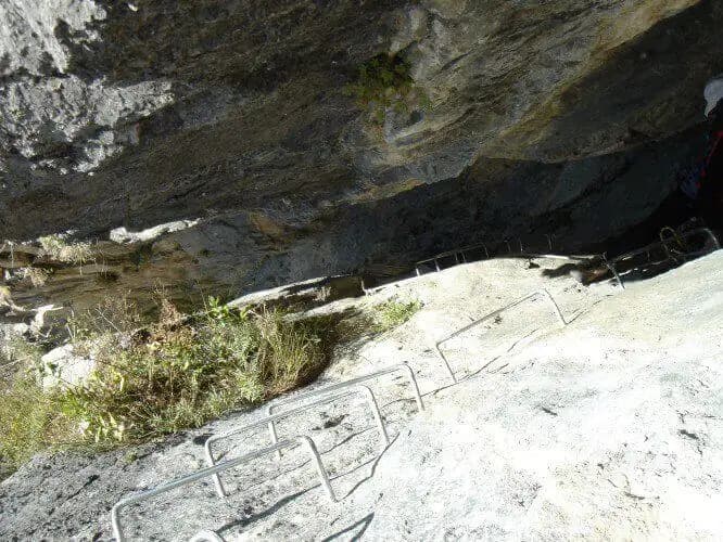
Sector A shares the start with sector B, ascending sloping slabs and rocky steps rich in stirrups. After the first slab, a traverse to the left skirts a bulge in the wall. Short vertical sections follow until a key junction: continuing straight up vertically enters sector B (Balma del Camoscio), while continuing the horizontal traverse to the left keeps you on route A. Proceeding, you tackle three vertical walls of increasing difficulty and progressive exposure, separated by non-technical traversing sections. In one specific passage, a bulky backpack can hinder progress; a quickdraw can be useful to temporarily secure it. Reaching a shoulder, the descent path from section B converges from the right, while to the left the escape route begins. The route continues with a long oblique traverse, a mix of horizontal and uphill progression, leading toward the cave area (Section C). Ignoring this deviation, the traverse continues to a suspension bridge. After crossing it, the assisted descent begins, a sequence of traverses and short vertical sections equipped with stirrups. This final section, never particularly difficult, ends after a few minutes. The climbing time for sector A alone, excluding deviations, is about 2 hours from the start. The pace is sustained but steady, with exposure that gradually increases, offering a continuous panorama of the valley.
Sector B branches off from the aforementioned junction, ascending a vertical section followed by a long traverse that requires good use of natural holds. You then tackle another demanding vertical section to reach the crux: a six-meter overhang, perfectly equipped with stirrups but tending to "bulge," pushing your body outward and putting serious strain on arm strength (a short quickdraw can make the move easier). The route, which here takes on a decidedly athletic and vertical character, continues with a slightly descending traverse that requires careful foot placement. You then overcome a dihedral and a pair of small overhangs, ending on an easy ridge that leads to the Rouas forest above. From here, a trail leads to the junction point with route A, where you can choose whether to continue on the via ferrata or descend to the valley. The time for this variant is 1 hour and 15 minutes from the junction. It is a continuous and physical sector, concentrating its main difficulty in a single, powerful overhanging passage on solid rock.
Section C is a short variant that branches off from route A. It consists of climbing a wall to access a natural cavity, crossed with a short suspended section, then descending back to the main route. It takes about 10 minutes from the deviation. This segment adds an element of play and exploration, breaking the linearity of the traverses with a small vertical ascent.
Descent
At the end of sector A, descend along a clear trail until you intercept a road. Follow it to the left to quickly return to the starting parking lot. The descent takes about 15 minutes from the end of the via ferrata. The total time for the excursion varies: about 2 hours and 20 minutes for sector A alone, while climbing all sections (A, B, and C) can take up to 4 hours. The quick, non-technical descent effectively closes the loop.
Useful Notes
The Ferrata del Rouas has a "French style": athletic, very well-equipped, and conceived as a standalone route, without the goal of reaching a specific summit. The main itinerary is fun and suitable for beginners, thanks to its excellent protection and logical progression, while variant B is reserved for experienced hikers due to its technical difficulty and concentrated physical effort. All protection materials are in excellent condition and recently installed. The Val di Susa offers numerous other possibilities for via ferrata enthusiasts, including those at Claviere, the Ferrata Guido Rossa at Caprie, the ferratas of the Orridi di Chianocco and Foresto, the Ferrata della Ruceia, and the recent Ferrata delle Cascate di Novalesa.
Track and weather
Plan the route
Preview the GPX track from the backend, download it for your GPS device, open parking directions, and check a short forecast before leaving.
Images
FAQ
What level of commitment does this via ferrata require?
ferrata.faqAnswers.commitment
How much elevation gain should I plan for?
The listed ferrata elevation gain is 125 m. Also consider approach, return and maximum altitude, because they can matter more than the equipped section alone.
Where is the route located?
Ferrata del Rouas is located in Alpi Graie, Torino, Italy. Before leaving, check parking, access and current local conditions.
When is the best time to climb it?
The best season depends on altitude, aspect and lingering snow. Avoid storms, wet rock and uncertain conditions; start early and keep a margin for the return.
Gear and safety planning
Use the technical data on this page to plan equipment, timing and offline navigation. For a general checklist, read the equipment guide before opening the route in the app.
Video
Watch the route
Useful YouTube videos for getting a real feel for the route before you go.
Logbook
Route condition reports
Recent community notes about closures, snow, equipment damage, trail issues and current conditions.
Community
Reviews, check-ins and photos
-
0 reviews
0
0 climbers
0
Shared by the community
Community photos
Recent images uploaded by Sferrati members.
No community photos yet
Open this route in the app to add the first photo.
Reviews
Recent impressions from climbers who know the route.
No reviews yet
Be the first to review this via ferrata from the app.
Continue in the app
Track the climb, save maps offline, and sync this route to your personal profile.
Use the app to climb
Offline maps, tracking, saves, and profile sync.
Scan the code before leaving, install the app, and keep your route data ready when reception fades.
