Overview
The Sentiero Attrezzato al Burrone Giovanelli winds through the deep, dramatic gorge of Mezzocorona in Trentino. Though classified as a equipped trail, it features vertical and exposed sections that give it the character of an easy via ferrata. The route is especially prized for its spectacular, enclosed canyon environment, with tall, narrow walls that provide shade and coolness even in summer, making it an ideal choice when higher elevations are still snowed in or on hot days.
Approach
The access point is the town of Mezzocorona, reachable from the San Michele all'Adige motorway exit. From here, follow Via Cesare Battisti toward Mezzolombardo; on the right, you'll spot a narrow paved lane that climbs steeply through terraced vineyards, ending at a spacious parking area with an information board.
From the parking lot, follow the signs for trail CAI 505, which immediately enters a mixed deciduous forest. After about five minutes of walking, you'll reach a marked junction: keep left on the more direct variant 505A, ignoring the right-hand branch that descends toward the valley floor. The trail climbs moderately, crosses a small wooden bridge over a stream, and continues along the right orographic side until, after roughly fifteen minutes total, you arrive at a marble plaque marking the official start of the fixed equipment.
Via Ferrata
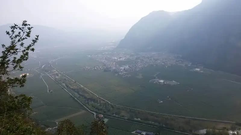
From the starting sign, a comfortable horizontal ledge protected by a steel cable leads to the base of the first waterfall. Here, cross the stream over boulders and reach the foot of a long metal ladder split into two sections. The climb is vertical and moderately exposed but technically straightforward; the only caution is the potential slipperiness of the rungs due to condensation or moisture. At the top of the ladder, a wide lookout opens onto the Rotaliana Plain, offering the first panoramic view.
The route continues along an equipped trail with short rocky steps, gradually entering the gorge environment. After passing a second, shorter ladder, a gently ascending ledge to the left leads to a narrow equipped passage-the true gateway to the canyon. A brief descent down a third ladder drops you into the heart of the Burrone Giovanelli, where the walls close in and the atmosphere becomes more intimate.
Climbing the right side of the canyon, you cross the stream again and begin a section featuring solid, wide metal rungs. The progression, always assisted by a cable, bends to the right and, after one last short ladder, emerges onto a ledge with a wooden walkway. Just beyond, you'll encounter a statue of the Madonna, marking the entrance to the narrowest and most evocative part of the gorge-a rocky corridor where light penetrates only during the central hours of the day.
Ascending alongside the stream in a setting of great beauty, you exit the bottleneck and reach a majestic waterfall about a hundred meters high. From here, the rhythm of the route changes, alternating between trail sections and short equipped stretches. You overcome a couple of rocky steps, typically damp and polished by water, and find yourself at the base of a final long, sloping ladder. Beyond this, the trail continues to one last short metal ladder, which marks the end of the fixed equipment. In about ten minutes of walking, you emerge onto a forest road at an elevation of 765 meters. The total travel time from the start is approximately 1 hour and 30 minutes, with 1 hour and 15 minutes dedicated to the ferrata itself.
Descent
From the forest road, you have three options for the return, listed in increasing order of duration:
- Keeping left, descend along trail 504 through the woods, reaching the parking area in about 45 minutes (total hike duration: approximately 2 hours and 30 minutes).
- Keeping right, follow trail 505 for about an hour, passing by Baita Manzi, to the top station of the cable car. From here, take the cable car down to the valley, then walk about 30 minutes east through Mezzocorona to return to your car (total duration: approximately 3 hours and 30 minutes).
- Once at the top station, continue on trail 500 in a steep descent equipped with some handrail ropes, which drops along a panoramic ridge to Mezzocorona, near the lower cable car station. From there, it's a 30-minute walk back to the parking area (total hike duration: approximately 4 hours).
Useful Notes
Despite its classification as an "equipped trail," the presence of vertical and exposed sections makes the Burrone Giovanelli comparable to a true via ferrata, albeit of low difficulty (grade F). It is a route suitable even for beginners, thanks to the solidity of the ladders and metal structures, which ensure safe progression. As with all via ferratas in a gorge environment, it is essential to carefully assess the stream conditions, especially in spring or after heavy rain, due to widespread humidity, potential water flow, and the resulting increase in difficulty. For maps, the Gruppo di Brenta or Val di Non sheets are recommended. The proximity to Mezzocorona and the short approach make this ferrata easy to combine with other equipped routes in the Val d'Adige and neighboring valleys.