
Technical data
- Difficulty
- Facile
- Status
- aperta
- Distance
- 6 km
- Total duration
- 3 h
- Approach
- 30 min
- Ferrata time
- 1 h
- Elevation gain
- 115 m
- Max altitude
- 1028 m
Route planning
How to plan Sentiero Attrezzato del Medale
Sentiero Attrezzato del Medale is in Prealpi Bergamasche, Lecco, Italy and is rated Facile. Available route data lists about 3 h total time, 6 km of distance, 115 m of elevation gain.
For day planning, consider an approach of about 30 min, about 60 min on the cable, a maximum altitude near 1028 m.
The page includes a parking or driving-directions reference. A GPX track is not available yet, so bring an alternative map source.
As with every via ferrata, evaluate season, lingering snow, storms, crowds and equipment condition. Page last updated on 7/4/2026.
Description
Overview
The Sentiero Attrezzato del Medale is the normal route to the summit of Corno del Medale, a dolomitic bastion rising north of Lecco. While it doesn't present high technical difficulties, the itinerary unfolds across a continuous, steep slope with often unstable and slippery terrain, demanding constant attention and a healthy dose of caution. The route fits perfectly into the area's network of trails, serving either as a standalone ascent or as a descent variant for more complex loops.
Approach
The starting point is the locality of Rancio Alto, above Lecco. From Lecco, take the road toward Ballabio until you reach a clear double hairpin turn in a residential area. Near the second hairpin, continue straight onto Via Quarto, on the left. After about two hundred meters, at a small square, spot a steep paved road on the right, marked by a rusty white open barrier. Take this road, pass a first left-hand hairpin, and at a fork, keep right and continue climbing. In a few minutes you'll reach a barrier where parking is possible.
Via Ferrata
From the parking area, follow the paved road that enters the woods beyond the last houses, turn at a hairpin, and continue to the former Rifugio Medale. From here, turn left following signs for Corno del Medale, tackling a steep climb through the forest on a trail with variable terrain, alternating between earthy and rocky sections. You'll reach the first equipped section with a chain in about forty minutes.
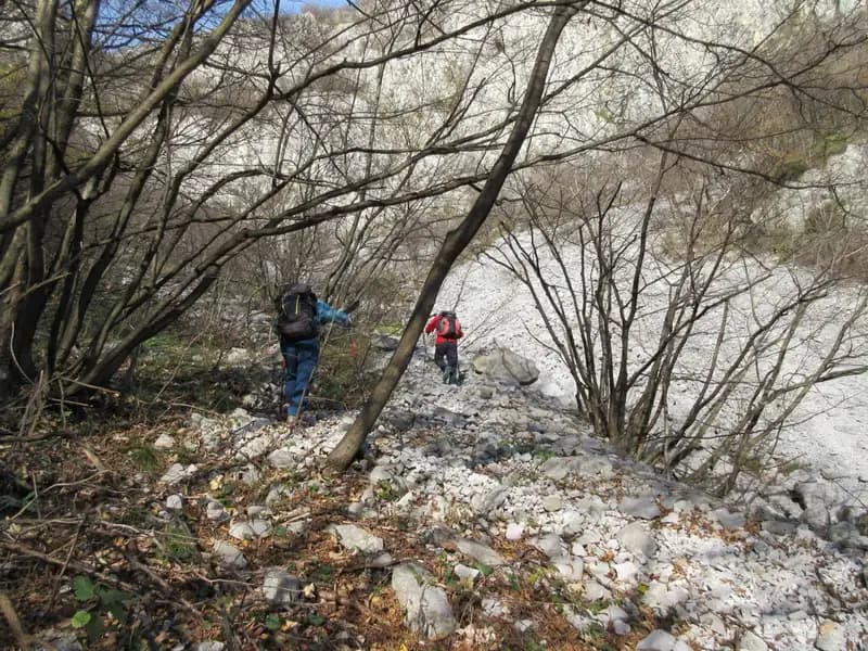
The first equipped sector is a sloping grassy ledge leading to a short, non-demanding rocky gully; here the steel cable runs laterally, offering a secure handhold. The route continues at a steady pace, climbing with numerous switchbacks along the northern slope. On a couple of these switchbacks, short chain sections provide useful support, especially appreciated on the descent or when the terrain is wet. The morphology is that of a grassy and rocky ridge, with a generally northern exposure that keeps the ground cool and sometimes damp. The final stretch, particularly steep and slippery, leads to a small saddle: to the right, trails branch off toward Coltiglione and San Martino, to the left toward Corno del Medale. Turning left, in less than five minutes you round a spur and climb the final meters to the prominent summit cross. The equipped section takes about an hour, for a total of one hour and forty minutes from the start.
Descent
For those intending to do only the Sentiero Attrezzato del Medale, the return is via the same ascent route, taking about one hour and fifteen minutes from the summit, for a total of around three hours.
From the saddle just below the summit of Corno del Medale, interesting alternatives open up for creating a loop. You can continue toward Monte San Martino and descend, for example, along the Sentiero Attrezzato della Vergella or the Sentiero Attrezzato Silvia. Alternatively, from the saddle you can climb to nearby Coltiglione via the Sentiero Attrezzato GER.
Useful Notes
The main difficulty of the Sentiero Attrezzato del Medale lies in the steep and often slippery terrain, especially in the second half of the route. All exposed sections are adequately protected by cables or chains. However, the climb is not recommended after heavy rain due to treacherous ground conditions. For more experienced hikers, this equipped trail serves as the natural return route after tackling the more challenging Ferrata del Gruppo Alpini on Corno del Medale.
Track and weather
Plan the route
Preview the GPX track from the backend, download it for your GPS device, open parking directions, and check a short forecast before leaving.
GPX track unavailable
This route does not include a downloadable track yet.
Images
FAQ
What level of commitment does this via ferrata require?
ferrata.faqAnswers.commitment
How much elevation gain should I plan for?
The listed ferrata elevation gain is 115 m. Also consider approach, return and maximum altitude, because they can matter more than the equipped section alone.
Where is the route located?
Sentiero Attrezzato del Medale is located in Prealpi Bergamasche, Lecco, Italy. Before leaving, check parking, access and current local conditions.
When is the best time to climb it?
The best season depends on altitude, aspect and lingering snow. Avoid storms, wet rock and uncertain conditions; start early and keep a margin for the return.
Gear and safety planning
Use the technical data on this page to plan equipment, timing and offline navigation. For a general checklist, read the equipment guide before opening the route in the app.
Video
Watch the route
Useful YouTube videos for getting a real feel for the route before you go.
Logbook
Route condition reports
Recent community notes about closures, snow, equipment damage, trail issues and current conditions.
Community
Reviews, check-ins and photos
-
0 reviews
1
1 climbers
0
Shared by the community
Community photos
Recent images uploaded by Sferrati members.
No community photos yet
Open this route in the app to add the first photo.
Reviews
Recent impressions from climbers who know the route.
No reviews yet
Be the first to review this via ferrata from the app.
Continue in the app
Track the climb, save maps offline, and sync this route to your personal profile.
Use the app to climb
Offline maps, tracking, saves, and profile sync.
Scan the code before leaving, install the app, and keep your route data ready when reception fades.
