
Technical data
- Difficulty
- Facile
- Status
- aperta
- Distance
- 12,8 km
- Total duration
- 6 h
- Approach
- 1 h 30 min
- Ferrata time
- 2 h 30 min
- Elevation gain
- 150 m
- Max altitude
- 2875 m
Route planning
How to plan Sentiero Attrezzato Sass de Putia
Sentiero Attrezzato Sass de Putia is in Sass de Putia, Bolzano, Italy and is rated Facile. Available route data lists about 6 h total time, 12,8 km of distance, 150 m of elevation gain.
For day planning, consider an approach of about 90 min, about 150 min on the cable, a maximum altitude near 2875 m. Reported route features include: Itinerario lungo.
The page includes a parking or driving-directions reference. A GPX track is available to review and download.
As with every via ferrata, evaluate season, lingering snow, storms, crowds and equipment condition. Page last updated on 7/4/2026.
Features
Description
Overview
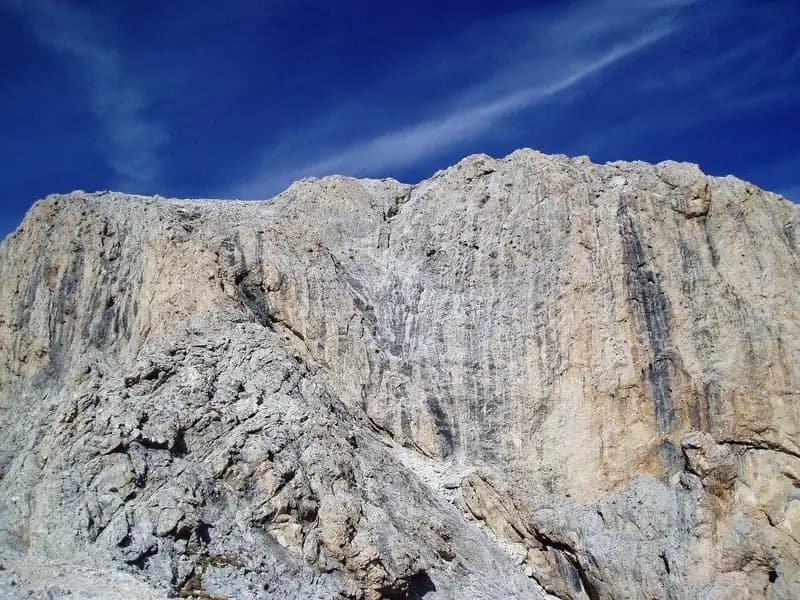
The Sentiero Attrezzato al Sass Putia is an ideal introductory route, unfolding on the southern flank of this imposing Dolomitic peak starting from the Passo delle Erbe. It offers an accessible mountaineering experience within an exceptional landscape setting, characterized by sweeping views that embrace the entire Odle Group, extending toward the Belluno Dolomites and the Aurine Alps. The route combines straightforward progression with a high-altitude environment, making it perfect for a first approach to the discipline.
Approach
The route begins at the Passo delle Erbe (1987 m), a pass connecting the Val d'Isarco to the Val Badia. The most common access is from the Chiusa motorway exit, taking the road toward the Val di Funes and then the pass. From the parking lot, dominated by the north face of the Sass de Putia, take the wide gravel track of trail 8. At the first junction, keep right on trail 8A, which continues on a false flat heading east, skirting the base of the north face. The trail gradually narrows on the western side, crossing several scree slopes, before joining trail 4 (Alta Via Günther Messner). This approach section, mostly level and free of technical difficulty, leads in about 1 hour and 30 minutes to the Forcella de Putia (2357 m), a saddle from which you get the first full view of the mountain's southern side and, below, the Rifugio Genova. The environment is classic Dolomitic, with broad debris slopes forming buttresses to the vertical walls.
Via Ferrata
From the saddle, signs to the left lead onto an easy grassy trail that traverses toward the wide, rocky plateau beneath the summit. Here begin the final 150 meters of ascent, equipped with a continuous steel cable despite the generally easy nature of the moves. The pace becomes more vertical but never challenging: first, tackle an easy sloping ramp, followed by a few short rocky steps. The only section requiring a bit of attention is a short chimney, characterized by a slightly high initial step, though made easier by a convenient stirrup on the right side of the crack. Past this point, the final rocky ledges lead directly to the summit cross of the Sass de Putia (2875 m), crowned by a magnificent 360-degree panorama. The progression is steady and pleasant, with the cable providing security without being technically necessary. The time from the Forcella de Putia is about 1 hour and 30 minutes, for a total of 3 hours from the start.
Descent
The descent follows the same via ferrata and grassy trail, returning to the Forcella de Putia in about 1 hour from the summit (total 4 hours). From here, you can retrace the approach route back to the Passo delle Erbe (about 1h 30', total 5h 30'), but a loop route is recommended. This variation involves following markers 4B and then 35, skirting the southern side of the Sass de Putia through green alpine pastures to the Passo di Goma (2111 m), reachable in 1 hour from the saddle. Keeping left, finally take trail 8B, which with a final hour of walking in moderate descent leads back to the parking lot, for a total of about 6 hours for the entire loop. This circular itinerary offers a more complete experience, varying the scenery and terrain type.
Useful Notes
Classified as an easy equipped trail, the route takes place in a striking alpine environment with great scenic impact. It features no exposed or technically demanding sections; the equipment is in excellent condition and well-distributed, especially in the final 150-meter stretch. Signage is excellent throughout the area, making navigation intuitive in this corner of the Odle Group, of absolute scenic interest. The route runs alongside the spectacular Alta Via Günther Messner, offering the possibility of combining the two excursions over two separate days. The area is rich in other mountaineering options, such as the Ferrata al Sasso de la Crusc, the Ferrata della Pace toward Corvara, or the Sentiero Attrezzato Tru Dolomieu.
Track and weather
Plan the route
Preview the GPX track from the backend, download it for your GPS device, open parking directions, and check a short forecast before leaving.
Images
FAQ
What level of commitment does this via ferrata require?
ferrata.faqAnswers.commitment
How much elevation gain should I plan for?
The listed ferrata elevation gain is 150 m. Also consider approach, return and maximum altitude, because they can matter more than the equipped section alone.
Where is the route located?
Sentiero Attrezzato Sass de Putia is located in Sass de Putia, Bolzano, Italy. Before leaving, check parking, access and current local conditions.
When is the best time to climb it?
The best season depends on altitude, aspect and lingering snow. Avoid storms, wet rock and uncertain conditions; start early and keep a margin for the return.
Gear and safety planning
Use the technical data on this page to plan equipment, timing and offline navigation. For a general checklist, read the equipment guide before opening the route in the app.
Video
Watch the route
Useful YouTube videos for getting a real feel for the route before you go.
Logbook
Route condition reports
Recent community notes about closures, snow, equipment damage, trail issues and current conditions.
Community
Reviews, check-ins and photos
-
0 reviews
0
0 climbers
0
Shared by the community
Community photos
Recent images uploaded by Sferrati members.
No community photos yet
Open this route in the app to add the first photo.
Reviews
Recent impressions from climbers who know the route.
No reviews yet
Be the first to review this via ferrata from the app.
Continue in the app
Track the climb, save maps offline, and sync this route to your personal profile.
Use the app to climb
Offline maps, tracking, saves, and profile sync.
Scan the code before leaving, install the app, and keep your route data ready when reception fades.
