Overview
The Favogna Ferrata is an intermediate-level protected route that runs along a steep limestone wall, creating a direct link between the Adige Valley and the namesake plateau, on the provincial border between Bolzano and Trento. This is a low-altitude itinerary, which means temperatures can be high in summer. It doesn't present any particularly high technical difficulties, though a couple of sections require more effort than the rest of the route, giving it a varied and pleasantly articulated character.
Approach
The access point is along provincial road 14, between Roverè della Luna in Trentino and Magrè in South Tyrol. Coming from the south, the recommended highway exit is San Michele all'Adige; from the north, Egna-Ora. On the Trentino side, at the provincial border sign, a hiking trail marker is visible at the roadside, on the mountain side. Park the car along the road, where the hike begins.
Via Ferrata
From the sign, climb steeply through the woods, overcoming a few short equipped rocky steps, until you reach the metal plaque marking the official start of the Favogna Ferrata (332 m, 10 minutes from the parking). The route opens immediately with a key passage: the start is in a rocky chimney, which constitutes the technically most demanding section of the entire route. The cable runs on the left; progression uses good natural rock holds and a couple of metal stirrups. This section, though short, requires good body positioning within the channel.
Once past the chimney, the route enters a debris-filled gully, then exits it keeping to the left. After a few steps in the woods, you find yourself at the base of a vertical wall equipped with a long series of metal stirrups. This sector has two distinctive features: it lacks a continuous cable, so you must clip directly into the stirrups, and the first meters require a short section of free climbing (grade I) to reach the first stirrups. The wall, compact and vertical, offers an athletic and continuous progression. Once up, you bend right to tackle a fairly low-angle metal ladder that leads to a panoramic terrace overlooking the Rotaliana plain. Then traverse right on an easy trail section.
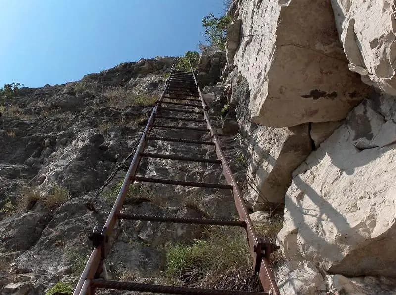
The route continues into a narrow gorge, crossed thanks to a new metal ladder, this time more exposed and slightly overhanging. The ladder, suspended in the void, gives a strong sense of exposure. After climbing the ladder, ascend some rock steps along a initially unstable gully that gradually consolidates. A traverse to the right leads to a panoramic balcony offering a wide view of the Adige Valley and its vineyards (45 minutes from the start).
Walk a stretch of trail to the left, heading toward an imposing overhanging wall. Ascend it via a slab of low-angle rock, then bend right until you reach the summit register. The pace here becomes more relaxed, with a horizontal and scenic progression. Continue always to the right, round an exposed corner, and climb the last low-angle rock steps. Here ends the Favogna Ferrata (975 m, 1 hour 30 minutes from the start, 1 hour 40 minutes total). Continue following the trail through the woods until you emerge onto the Favogna plateau, near the first houses (30 minutes from the end of the ferrata, 2 hours 15 minutes total).
Descent
Two options are possible for the return: To the right, follow trail 3, which with a moderate descent leads to Magrè (2 hours from the end of the ferrata, 4 hours 15 minutes total). From here, walking the provincial road south, you return to the parking (about 5 hours total). To the left, walk about 1 km of paved road until you take the CAI trail 519. Reach a junction indicating Roverè della Luna along trail 502B. This trail descends steeply, requiring free descent of a couple of rock steps (grade I) and fording a stream. Once in Roverè della Luna, cross the town and follow the provincial road back to the car (1 hour 45 minutes from the end of the ferrata, 4 hours total).
Useful Notes
The Favogna Ferrata is a medium-difficulty route, with two more challenging sections: the initial chimney and the wall with stirrups. The metal equipment is a bit loose in some spots, which can make progression more tiring for the less experienced. Both descent options are quite long. It might be strategic to park the car near your chosen return point, tackling a longer approach at the start of the day when you're fresh. At the start of the route, there is a sign warning of the possible presence of ticks. For maps, the 4Land maps of the Val di Non or the Strada del Vino and Monte Corno area are recommended.