
Ferrata Croce di Fai
Monte Fausior · Trento · Italy
Technical data
- Difficulty
- Moderatamente Difficile
- Status
- aperta
- Distance
- 4,4 km
- Total duration
- 2 h 30 min
- Approach
- 30 min
- Ferrata time
- 1 h
- Elevation gain
- 300 m
- Max altitude
- 1490 m
Route planning
How to plan Ferrata Croce di Fai
Ferrata Croce di Fai is in Monte Fausior, Trento, Italy and is rated Moderatamente Difficile. Available route data lists about 2 h 30 min total time, 4,4 km of distance, 300 m of elevation gain.
For day planning, consider an approach of about 30 min, about 60 min on the cable, a maximum altitude near 1490 m. Reported route features include: Scale, Avvicinamento corto.
The page includes a parking or driving-directions reference. A GPX track is available to review and download.
As with every via ferrata, evaluate season, lingering snow, storms, crowds and equipment condition. Page last updated on 7/4/2026.
Features
Description
Overview
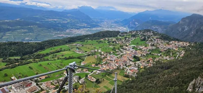
The Ferrata della Croce di Fai is a modern, compact route that climbs the eastern flank of Monte Fausior, overlooking the village of Fai della Paganella and the Piana Rotaliana. This is a predominantly vertical itinerary of medium difficulty, with a couple of short but athletic sections that demand a higher physical commitment. The abundance of metal staples is well integrated with natural footholds, while handholds on the smooth slabs are more limited. Its eastern exposure makes it ideal for the shoulder seasons or winter, while it is not recommended during the hottest hours of summer. The route is developed as a loop.
Approach
The starting point is a large dirt clearing used as a parking area and picnic spot, located on the provincial road to Fai della Paganella, just before entering the town and opposite a gas station (approximately 930 m). Here you will find the information board. Take a path through the woods that initially proceeds on a gentle grade. After a few minutes, near two benches, you reach a fork: keep right, beginning a steeper climb through the forest, well-marked, which in about 20 minutes leads to the start sign of the via ferrata (1170 m). The total time from the car is about 30 minutes.
Via Ferrata
The ascent begins with a vertical section that zigzags between rock outcrops and staples, soon offering a broad panorama of the Altopiano della Paganella, the Piana Rotaliana, and the Valle dell'Adige. The route develops along a compact rocky ridge, typically dolomitic, with a continuous and well-paced progression. After a short horizontal stretch, you tackle a long, exposed series of stone steps, the first more challenging passage, where some vertical staples serve as useful handholds. This very airy section requires good body positioning. You continue always vertically, smoothly alternating between metal and rock.
You then reach a spur on the ridge, beyond which you tackle a second, thinner spur, climbing vertically and traversing its horizontal crest. This section offers a ridge-climbing experience with lateral exposure. Short grassy ramps and an equipped section through the woods follow, from where you can glimpse the destination in the distance. Once this first section is completed, you follow a normal trail for about ten minutes to a new red sign indicating the start of the second part. There are no escape routes between the two sections.
The second part begins with less vertical sections, characterized by small rock outcrops. You then alternate between short vertical stretches on staples and easy traverses, until you reach a smooth slab topped by a slight overhang. Here lies the second key passage: a well-tensioned ladder of slings that requires a certain amount of arm strength to overcome. This technical and athletic move interrupts the more relaxed progression that precedes it. Once this step is completed, the final meters are exposed, with staples on the slab moving both vertically and transversely. A few easy rock steps and mixed terrain finally lead to the Croce di Fai at an elevation of 1465 m. The arrival point, equipped with a bench and table, is an excellent viewpoint for a rest and to remove your gear. The climbing time for the via ferrata is about 1 hour and 30 minutes (2 hours total from the start).
Descent
From the cross, a short path emerges after a few meters onto a forest road. Follow it to the right (opposite side from the ascent), initially on a slight uphill and then descending. After about 15 minutes, take the fork to the right marked for the Sentiero 604 "Bocca delle Scalacce - Fontana Bianca - Fai", then join the Sentiero 603 "Fontana Bianca - Fai". This trail skirts Monte Fausior and leads back comfortably to the starting parking area. The descent takes about 50 minutes, for a total loop time of about 3 hours.
Useful Notes
This Ferrata della Croce di Fai is climbable for most of the year, but it is essential to avoid the central hours on the hottest summer days due to its eastern exposure. Modern in design, it offers safe progression thanks to the abundant staples, which compensate for the smooth rock, though it does not lack exposure in several sections. The difficulty is medium, with two short athletic sections. It is an excellent choice for a half-day outing on the Paganella plateau. For more trained hikers, there is the possibility of linking it with the nearby Ferrata Val del Ri, forming a longer and more challenging itinerary.
Track and weather
Plan the route
Preview the GPX track from the backend, download it for your GPS device, open parking directions, and check a short forecast before leaving.
Images
FAQ
What level of commitment does this via ferrata require?
ferrata.faqAnswers.commitment
How much elevation gain should I plan for?
The listed ferrata elevation gain is 300 m. Also consider approach, return and maximum altitude, because they can matter more than the equipped section alone.
Where is the route located?
Ferrata Croce di Fai is located in Monte Fausior, Trento, Italy. Before leaving, check parking, access and current local conditions.
When is the best time to climb it?
The best season depends on altitude, aspect and lingering snow. Avoid storms, wet rock and uncertain conditions; start early and keep a margin for the return.
Gear and safety planning
Use the technical data on this page to plan equipment, timing and offline navigation. For a general checklist, read the equipment guide before opening the route in the app.
Video
Watch the route
Useful YouTube videos for getting a real feel for the route before you go.
Logbook
Route condition reports
Recent community notes about closures, snow, equipment damage, trail issues and current conditions.
Community
Reviews, check-ins and photos
-
0 reviews
6
5 climbers
4
Shared by the community
Community photos
Recent images uploaded by Sferrati members.
Reviews
Recent impressions from climbers who know the route.
No reviews yet
Be the first to review this via ferrata from the app.
Continue in the app
Track the climb, save maps offline, and sync this route to your personal profile.
Use the app to climb
Offline maps, tracking, saves, and profile sync.
Scan the code before leaving, install the app, and keep your route data ready when reception fades.
