
Technical data
- Difficulty
- Facile
- Status
- aperta
- Distance
- 3,5 km
- Total duration
- 2 h 15 min
- Approach
- 15 min
- Ferrata time
- 1 h 30 min
- Elevation gain
- 170 m
- Max altitude
- 1170 m
Route planning
How to plan Ferrata di Locana
Ferrata di Locana is in Alpi Graie, Torino, Italy and is rated Facile. Available route data lists about 2 h 15 min total time, 3,5 km of distance, 170 m of elevation gain.
For day planning, consider an approach of about 15 min, about 90 min on the cable, a maximum altitude near 1170 m. Reported route features include: Ponti sospesi, Avvicinamento corto.
The page includes a parking or driving-directions reference. A GPX track is available to review and download.
As with every via ferrata, evaluate season, lingering snow, storms, crowds and equipment condition. Page last updated on 7/4/2026.
Features
Description
Overview
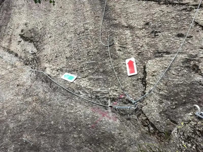
The Locana Via Ferrata, also known as the San Lorenzo Piantonetto Via Ferrata, winds through the Gran Paradiso National Park, climbing a compact, solid slab of granite in the Piantonetto Valley. This is a recently built route, methodically equipped with a dense succession of metal staples that simplify progression. This makes it an excellent choice for gaining confidence in the via ferrata environment, while more experienced climbers may find the abundance of artificial aids reduces the purely technical rock challenge.
The itinerary unfolds mainly on a compact granite face, characterized by a smooth morphology that favors continuous, steady climbing. The massive presence of staples defines a cadenced, secure rhythm, offering an experience that is more physical than technical, with moderate and constant exposure. Though vertical, the route is scenic and educational, ideal for a structured first approach to the via ferrata environment.
Approach
Access is from Rosone, in the Orco Valley. Leaving the hamlet toward the Gran Paradiso National Park, turn right at the second junction marked for Piantonetto. A narrow paved road, skirting the stream, climbs with a series of switchbacks to a large dirt clearing used as a parking area. The approach trail, clearly indicated by an information panel, takes about twenty minutes. From the parking lot, cross the road and take a path on the opposite side of the watercourse, which rises through the forest to the south until reaching the foot of the first cables.
The approach takes place in a typical mid-mountain forest environment, with a modest elevation gain and a steady pace. The well-maintained trail gradually prepares you for the rocky environment ahead, without presenting any challenging passages.
Via Ferrata
The start is near a high-voltage pylon. After a few meters of climbing, a short, easy traversing section leads to a suspension bridge of about thirty meters, which can be avoided on the right via an alternative path. Past the bridge, the route turns left with another simple traverse, then tackles a first equipped wall of about fifteen meters, made easier by numerous natural holds in the rock.
The route continues left until it intersects the trail that will be used for the descent. Ignoring the deviations, you attack a vertical wall extremely rich in metal staples, which constitutes the most challenging section of the ascent. A further connection leads to the foot of the last vertical wall, beyond which the ascending part concludes.
The via ferrata develops on a continuous granite slab, with a predominantly vertical layout broken by ledges and short connecting sections. The pace is sustained and linear, without significant ups and downs, while the exposure is constant but never extreme. The character of the route is decidedly physical and educational, thanks to the dense sequence of staples that allows methodical, secure progression, while offering wide views of the valley.
Descent
Once the climb is complete, follow the cable to the right, descending along a rocky slab. You thus reach the junction encountered earlier and continue descending to a rocky overhang. After crossing it, continue alternating trail sections with short equipped passages, until you spot the suspension bridge and return to the starting point near the pylon. From here, retrace the approach trail back to the parking lot.
The descent takes place partly on trail and partly on short equipped sections, maintaining a varied and pleasant rhythm. The environment alternates between rock and sparse vegetation, with less exposure than the ascent. The return path completes the loop, confirming the accessible and well-structured character of the entire itinerary.
Useful Notes
This modern, well-maintained via ferrata is generally rated as easy difficulty and represents an ideal choice for a first approach to the activity, before tackling the more challenging itineraries in the area. The route describes a figure-eight pattern, with an intersection point between ascent and descent that can serve as a useful escape route for those wishing to interrupt the climb. In the nearby Orco Valley, descending toward Pont Canavese, you'll find the more challenging Pont Canavese Via Ferrata, with a normal variant of high difficulty and an extreme one not to be underestimated. The province of Turin offers numerous other possibilities, including via ferratas in the Susa Valley and those in the Chisone and Germanasca valleys.
Track and weather
Plan the route
Preview the GPX track from the backend, download it for your GPS device, open parking directions, and check a short forecast before leaving.
Images
FAQ
What level of commitment does this via ferrata require?
ferrata.faqAnswers.commitment
How much elevation gain should I plan for?
The listed ferrata elevation gain is 170 m. Also consider approach, return and maximum altitude, because they can matter more than the equipped section alone.
Where is the route located?
Ferrata di Locana is located in Alpi Graie, Torino, Italy. Before leaving, check parking, access and current local conditions.
When is the best time to climb it?
The best season depends on altitude, aspect and lingering snow. Avoid storms, wet rock and uncertain conditions; start early and keep a margin for the return.
Gear and safety planning
Use the technical data on this page to plan equipment, timing and offline navigation. For a general checklist, read the equipment guide before opening the route in the app.
Video
Watch the route
Useful YouTube videos for getting a real feel for the route before you go.
Logbook
Route condition reports
Recent community notes about closures, snow, equipment damage, trail issues and current conditions.
Community
Reviews, check-ins and photos
-
0 reviews
2
2 climbers
0
Shared by the community
Community photos
Recent images uploaded by Sferrati members.
No community photos yet
Open this route in the app to add the first photo.
Reviews
Recent impressions from climbers who know the route.
No reviews yet
Be the first to review this via ferrata from the app.
Continue in the app
Track the climb, save maps offline, and sync this route to your personal profile.
Use the app to climb
Offline maps, tracking, saves, and profile sync.
Scan the code before leaving, install the app, and keep your route data ready when reception fades.
