
Technical data
- Difficulty
- Facile
- Status
- aperta
- Distance
- 4 km
- Total duration
- 1 h
- Approach
- 30 min
- Ferrata time
- 20 min
- Elevation gain
- 90 m
- Max altitude
- 1390 m
Route planning
How to plan Ferrata Marguerettaz
Ferrata Marguerettaz is in Alpi Graie, Aosta, Italy and is rated Facile. Available route data lists about 1 h total time, 4 km of distance, 90 m of elevation gain.
For day planning, consider an approach of about 30 min, about 20 min on the cable, a maximum altitude near 1390 m. Reported route features include: Scale, Avvicinamento corto.
The page includes a parking or driving-directions reference. A GPX track is not available yet, so bring an alternative map source.
As with every via ferrata, evaluate season, lingering snow, storms, crowds and equipment condition. Page last updated on 7/4/2026.
Features
Description
Overview
The Ferrata Marguerettaz is an ideal introductory route for protected climbing. This straightforward path, free of significant technical obstacles, unfolds in a safe and secluded setting, perfect for a first taste of the discipline. Quick and simple access makes it undemanding and easy to enjoy.
Approach
The route begins near Morgex, in the Aosta Valley. From Morgex, take the SR39 toward Arpy and drive to the ninth hairpin turn, where a first clearing allows for parking. From here, proceed on foot for about two hundred meters uphill. Alternatively, continue by car for another two hundred meters past the hairpin to find two additional small parking spots, one on each side, with limited capacity. From the roadside parking, take a dirt track on the right side, closed to vehicles. Follow this forest path, well-marked with yellow-and-black trail signs for the "Hans Marguerettaz" climbing crag. The trail climbs to a fork, where you keep right on a slight traverse; cross a stream over a small wooden bridge and arrive at the first cliffs. Skirt the rocky outcrop on the right, pass the area dedicated to children, and tackle a few switchbacks until you reach the start of the steel cables. The approach takes about thirty minutes.
Via Ferrata
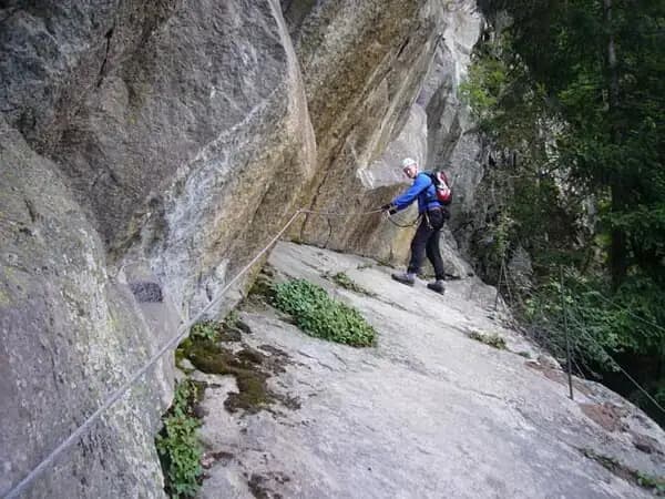
The equipped route begins by ascending a vertical wall, aided by comfortable stirrups. A short detour to the left leads to a long ledge, the starting point for several climbing routes. The path continues along a wide, equipped dihedral with stirrups, then traverses easily to the right on a horizontal section. After a few easy rocky steps, you reach the base of a red ladder with a safety cable. Climb it, move left, and tackle a second red ladder, which leads to a climbing pitch; the actual via ferrata ends on the left. The time on the ferrata itself is about twenty minutes, for a total of fifty minutes from the start of the approach.
The ferrata runs mainly over solid, compact rock, typical of the local formations, offering a protected environment. The pace is pleasant and steady, with no exposed or physically demanding passages, allowing you to focus on basic technique in complete safety. The route is predominantly vertical in its initial sections, then opens onto ledges and wide dihedrals, with moderate exposure that ensures a panoramic experience without anxiety.
Descent
The recommended option is to descend via the ascent route, retracing the equipped path in reverse. This choice is an excellent opportunity to become familiar with down-climbing maneuvers in a simple, complication-free setting. Alternatively, you can bypass the rocky spur on its left (orographic), briefly climbing a marked red forest trail, then descend near the climbing routes and retrace the approach path to the parking lot. For the descent, allow roughly between thirty minutes and one hour and thirty minutes total from the start of the excursion.
Useful Notes
This Ferrata Marguerettaz at Morgex is perfect for initiation: it presents no technical difficulties, excessive exposure, or environmental challenges. For climbing enthusiasts, the nearby crag offers numerous low-grade pitches, ideal for beginners. In the same area, continuing up the valley, you can reach the more demanding Ferrata del Bicentenario al Mont Chetif. For a progression route with children, valid alternatives can be found in the Gressoney Valley with the Ferrata Harry Potter and the Ferrata dei Bambini.
Track and weather
Plan the route
Preview the GPX track from the backend, download it for your GPS device, open parking directions, and check a short forecast before leaving.
GPX track unavailable
This route does not include a downloadable track yet.
Images
FAQ
What level of commitment does this via ferrata require?
ferrata.faqAnswers.commitment
How much elevation gain should I plan for?
The listed ferrata elevation gain is 90 m. Also consider approach, return and maximum altitude, because they can matter more than the equipped section alone.
Where is the route located?
Ferrata Marguerettaz is located in Alpi Graie, Aosta, Italy. Before leaving, check parking, access and current local conditions.
When is the best time to climb it?
The best season depends on altitude, aspect and lingering snow. Avoid storms, wet rock and uncertain conditions; start early and keep a margin for the return.
Gear and safety planning
Use the technical data on this page to plan equipment, timing and offline navigation. For a general checklist, read the equipment guide before opening the route in the app.
Video
Watch the route
Useful YouTube videos for getting a real feel for the route before you go.
Logbook
Route condition reports
Recent community notes about closures, snow, equipment damage, trail issues and current conditions.
Community
Reviews, check-ins and photos
-
0 reviews
0
0 climbers
0
Shared by the community
Community photos
Recent images uploaded by Sferrati members.
No community photos yet
Open this route in the app to add the first photo.
Reviews
Recent impressions from climbers who know the route.
No reviews yet
Be the first to review this via ferrata from the app.
Continue in the app
Track the climb, save maps offline, and sync this route to your personal profile.
Use the app to climb
Offline maps, tracking, saves, and profile sync.
Scan the code before leaving, install the app, and keep your route data ready when reception fades.
