
Technical data
- Difficulty
- Facile
- Status
- aperta
- Distance
- 6,4 km
- Total duration
- 3 h 30 min
- Approach
- 1 h 20 min
- Ferrata time
- 1 h
- Elevation gain
- 108 m
- Max altitude
- 2950 m
Route planning
How to plan Sentiero attrezzato Grande Chenalette
Sentiero attrezzato Grande Chenalette is in Alpi Pennine, Aosta, Italy and is rated Facile. Available route data lists about 3 h 30 min total time, 6,4 km of distance, 108 m of elevation gain.
For day planning, consider an approach of about 80 min, about 60 min on the cable, a maximum altitude near 2950 m. Reported route features include: Alta montagna, Scale.
The page includes a parking or driving-directions reference. A GPX track is not available yet, so bring an alternative map source.
As with every via ferrata, evaluate season, lingering snow, storms, crowds and equipment condition. Page last updated on 7/4/2026.
Features
Description
Overview
This route, while not demanding advanced technique, offers an authentic alpine experience in a severe and grand setting. The Great St Bernard Pass, with its austere climate, provides the backdrop for an easy-access via ferrata, ideal for a first taste of this type of progression. For fit hikers seeking a challenge, the route can be extended into a demanding loop that, from the summit of Gran Chenalette, continues along the ridge toward Monte Dronaz and Mont Fourchon, adding length and exposure.
Approach
Access is from the Swiss side of the Great St Bernard Pass. After leaving your car near the ancient hospice, begin climbing behind the building, skirting the lake. Take a paved road toward the kennel, which soon becomes a trail. The route unfolds across grassy and morainic slopes, with a steady pace and moderate gradients. You quickly reach the remains of an old dismantled chairlift, where the bases of the pylons and the top station, the Belvedere, are still visible. From here, following white waymarks, head west toward a rocky bastion, then bear right onto grassy slopes. A short stretch of easy rock leads to a gentler terrace, offering views of two lakes and introducing the valley of the Gran Chenalette. Now proceed on white-and-red markers, staying on the left side of the valley. The terrain becomes more mineral, with the trail crossing a rocky section before reaching the Belvedere (2,650 m), the former top station of the lift. Passing it to the north, follow a track over scree (marked "Ferret" in red) to an ascending traverse where the actual via ferrata begins (2,780 m). The approach from the parking lot takes about 1 hour and 20 minutes and gradually prepares you for the high-altitude environment.
Via Ferrata
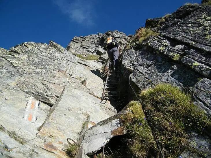
The start of the via ferrata begins with a comfortable ledge equipped with steps, a horizontal section that lets you get your bearings. The route develops mostly on solid, schistose rock, winding along ledges and sloping slabs. You then reach a dihedral, easily overcome thanks to cables and metal rungs. Immediately after, you encounter the first ladder, quite low-angle, followed shortly by a second. The pace is pleasantly broken by these short, secure vertical passages, interspersed with trail sections. Continue on a track that climbs over some boulders to a third ladder. This leads to a sloping slab, equipped with chains, which, turning left, brings you near the summit of Gran Chenalette (2,900 m). The final stretch is particularly panoramic, exposed on both sides. The summit position rewards you with a breathtaking 360-degree panorama. The via ferrata is short and not very technical, with a more hiking than mountaineering character. The climbing time is about 1 hour, for a total of 2 hours and 30 minutes from the parking lot.
Descent
The return follows the same route as the ascent, requiring care on the equipped sections and scree slopes. The total time for the excursion, including descent, is about 3 hours and 30 minutes.
Useful Notes
The harsh climate typical of the Great St Bernard Pass area demands careful preparation and attention to weather conditions, with gear suitable for possible sudden changes. In early summer, the section between the Belvedere and the start of the via ferrata may be affected by snow patches, requiring caution and on-site assessment. The equipped section presents no significant technical difficulties and can serve as an excellent introduction to the world of via ferratas for hikers already experienced in the mountains. For those wishing to extend the outing, from the summit it is possible to continue toward Monte Dronaz (or Monte Drone) by crossing a rocky slab equipped to the northeast, then descending on another via ferrata and closing the loop back to the pass. This option requires greater endurance and familiarity with exposure. An even longer and more demanding option, reserved for experts on exposed terrain, involves continuing along the ridge to Mont Fourchon. Nearby, descending toward Aosta, you'll also find the Ferrata delle Crete Sech, a rather long route that is difficult to combine in a single day with the Sentiero Attrezzato della Gran Chenalette.
Track and weather
Plan the route
Preview the GPX track from the backend, download it for your GPS device, open parking directions, and check a short forecast before leaving.
GPX track unavailable
This route does not include a downloadable track yet.
Images
FAQ
What level of commitment does this via ferrata require?
ferrata.faqAnswers.commitment
How much elevation gain should I plan for?
The listed ferrata elevation gain is 108 m. Also consider approach, return and maximum altitude, because they can matter more than the equipped section alone.
Where is the route located?
Sentiero attrezzato Grande Chenalette is located in Alpi Pennine, Aosta, Italy. Before leaving, check parking, access and current local conditions.
When is the best time to climb it?
The best season depends on altitude, aspect and lingering snow. Avoid storms, wet rock and uncertain conditions; start early and keep a margin for the return.
Gear and safety planning
Use the technical data on this page to plan equipment, timing and offline navigation. For a general checklist, read the equipment guide before opening the route in the app.
Video
Watch the route
Useful YouTube videos for getting a real feel for the route before you go.
Logbook
Route condition reports
Recent community notes about closures, snow, equipment damage, trail issues and current conditions.
Community
Reviews, check-ins and photos
-
0 reviews
0
0 climbers
0
Shared by the community
Community photos
Recent images uploaded by Sferrati members.
No community photos yet
Open this route in the app to add the first photo.
Reviews
Recent impressions from climbers who know the route.
No reviews yet
Be the first to review this via ferrata from the app.
Continue in the app
Track the climb, save maps offline, and sync this route to your personal profile.
Use the app to climb
Offline maps, tracking, saves, and profile sync.
Scan the code before leaving, install the app, and keep your route data ready when reception fades.
