
Leonardo Dalbon
Jun 7, 2026
Ferrata tranquilla adatta a tu...
Ferrata tranquilla adatta a tutti
FacileEsposizioneAvvicinamentoRientroParcheggio

Route planning
Ferrata Rio Sallagoni is in Prealpi Gardesane, Trento, Italy and is rated Facile. Available route data lists about 1 h 20 min total time, 3 km of distance, 150 m of elevation gain.
For day planning, consider an approach of about 10 min, about 40 min on the cable, a maximum altitude near 365 m. Reported route features include: Ponti sospesi, Avvicinamento corto.
The page includes a parking or driving-directions reference. A GPX track is available to review and download.
As with every via ferrata, evaluate season, lingering snow, storms, crowds and equipment condition. Page last updated on 7/4/2026.
The Rio Sallagoni Via Ferrata, near Castel Drena, is a highly appealing equipped route that winds through the deep and scenic gorge carved by the stream of the same name. It is a moderately difficult itinerary, suitable even for beginners, yet offering undeniable environmental value. Precisely because of this combination of accessibility and beauty, the gorge sees heavy foot traffic, especially during the summer months. To make the most of the ascent and avoid congestion in the narrow environment, it is best to start early in the morning or late in the afternoon, while also steering clear of the midday heat.
The route develops predominantly horizontally, unfolding as a series of traverses along ledges and slabs that follow the gorge's contours. The exposure is often pronounced but not extreme, providing a continuous sense of adventure without demanding significant physical effort. The pace is steady and linear, with few notable ups and downs, allowing you to focus on the spectacular surroundings.
The starting point is located along the provincial road connecting Dro to Drena, in Trentino. Coming from Riva del Garda, just before entering the town of Dro, follow the signs to the right for Drena. After a few minutes of climbing, immediately after a hairpin turn, you will find a large parking area on the left; a bit further ahead, on the right, a tambourine court is visible. Park in the designated area. From here, walk back down on foot toward the hairpin turn you just passed by car. On the left side of the road, a signpost with CAI trail markers unmistakably indicates the start of the path, which descends in about ten minutes to the entrance of the Rio Sallagoni gorge and the start of the via ferrata.
The equipped route begins on the left side of the gorge. After an initial climb of a few meters assisted by the cable, you make a short traverse to the right, aided by stirrups, then ascend diagonally and subsequently vertically. This first section is quite exposed and very impressive, with the stream roaring several meters below. The route continues traversing until you encounter a slightly more challenging passage, marked by a gentle overhang that requires light pull on the cable to maintain balance. Once past this short stretch-arguably the most technical of the entire route-you pass under a wedged boulder and spot an escape route that climbs vertically. To continue into the gorge, instead, keep traversing to the right.
Here, the gorge's morphology becomes narrower, and the trail continues with a long traverse that is not difficult, though it does feature some passages requiring attention. Near a large wedged boulder, where the gorge is particularly tight, you cross to the right side, then resume the traverse by overcoming a slightly more challenging rocky protrusion. Shortly after, the fixed equipment ends, and you find yourself in a magnificent setting, with waterfalls cascading ahead and an imposing rocky amphitheater towering above.
This marks the start of the second part of the via ferrata. Take the path to the left and soon reach the first three-rope suspension bridge, about fifteen meters long and sufficiently stable. After crossing it, continue on the right side of the stream along an equipped trail and a few easy rocky steps. Shortly after, cross the stream again on the left side of the bridge to tackle the only vertical climbing section of the route, which develops to the right. A few individual moves require a bit of effort, but the difficulty level remains low. In no time, you arrive at the second suspension bridge, shorter than the previous one but less stable. This marks the end of the Castel Drena Via Ferrata, reached about forty minutes from the start of the route (fifty minutes total from the beginning of the hike).
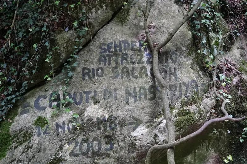
"Caduti di Nassiriya" Variant: Since late 2024, the via ferrata has been extended with an optional final variant dedicated to the Fallen of Nassiriya. From the end of the main equipment, instead of crossing the stream, stay on the left (orographic) bank, following an ascending path that leads to new equipped sections. These are quite easy, except for a ramp that can sometimes be damp and slippery. The route climbs the stream bed with a series of traverses on metal beams, in a very evocative setting. It is essential to pay maximum attention to the stream crossings, which in spring or after heavy rain can be more challenging (a pair of trekking poles can be helpful). From the end of this variant, an ascending path leads to Castel Drena in less than ten minutes. Compared to standard times, completing the variant adds about thirty minutes total.
The rock is compact and polished by millennia of water action, offering good friction for foot placements. The character of the route is distinctly panoramic and continuous, with exposure constantly accompanying the hiker along the gorge walls. The itinerary demands more agility than strength, with a rhythm punctuated by natural brief pauses in the wider spots.
From the end of the classic via ferrata, cross a small wooden bridge to return to the right bank of the stream and ascend a trail until you emerge near Castel Drena (about ten minutes). From the castle, taking the paved road downhill, you will notice a path on the left that, with a steep switchback descent, leads back in twenty minutes to the tambourine court and then to the initial parking area. The total time for the hike, including the classic via ferrata, is about one hour and twenty minutes.
This itinerary is extremely popular, especially in the summer months, with numerous groups of tourists. The risk of encountering queues inside the narrow gorge is real. Therefore, it is strongly recommended to do it early in the morning or late in the afternoon, also avoiding the hottest hours of the day. The Rio Sallagoni Via Ferrata is particularly well-suited for the shoulder seasons. For maps, you can consult the 4Land maps of Alto Garda and Valle di Ledro, Valle dei Laghi and Alto Sarca, or Pasubio and Vallagarina.
The experience is marked by a strong sensory impact, from the constant sound of water, the sight of waterfalls, and the feeling of progressing through a closed, vertical environment. It is a route that balances simple technical aspects with a highly evocative natural setting, making it an excellent introduction to the world of via ferratas.
Track and weather
Preview the GPX track from the backend, download it for your GPS device, open parking directions, and check a short forecast before leaving.
ferrata.faqAnswers.commitment
The listed ferrata elevation gain is 150 m. Also consider approach, return and maximum altitude, because they can matter more than the equipped section alone.
Ferrata Rio Sallagoni is located in Prealpi Gardesane, Trento, Italy. Before leaving, check parking, access and current local conditions.
The best season depends on altitude, aspect and lingering snow. Avoid storms, wet rock and uncertain conditions; start early and keep a margin for the return.
Use the technical data on this page to plan equipment, timing and offline navigation. For a general checklist, read the equipment guide before opening the route in the app.
Video
Useful YouTube videos for getting a real feel for the route before you go.
Logbook
Recent community notes about closures, snow, equipment damage, trail issues and current conditions.
Community
5.0
2 reviews
2
2 climbers
6
Shared by the community
Recent images uploaded by Sferrati members.
Recent impressions from climbers who know the route.
Jun 7, 2026
Ferrata tranquilla adatta a tutti

Feb 8, 2026
Splendida ferrata all’interno di un fresco Canyon, se fatta in estate la volta vegetazione della parte centrale vi farà sentire di essere dentro Jurassic Park! Recentemente è stata aggiunta una parte finale che permette di visitare l’intera fora, e rende ancora più bella l’esperienza! La ferrata è relativamente facile ma richiede qualche attenzione, ideale per iniziare! I weekend spesso molto affollata 
1
Track the climb, save maps offline, and sync this route to your personal profile.
Use the app to climb
Scan the code before leaving, install the app, and keep your route data ready when reception fades.
