
Technical data
- Difficulty
- Difficile
- Status
- aperta
- Distance
- 8,7 km
- Total duration
- 3 h 30 min
- Approach
- 1 h
- Ferrata time
- 1 h 30 min
- Elevation gain
- 230 m
- Max altitude
- 2450 m
Route planning
How to plan Ferrata Rocca Senghi
Ferrata Rocca Senghi is in Alpi Marittime, Cuneo, Italy and is rated Difficile. Available route data lists about 3 h 30 min total time, 8,7 km of distance, 230 m of elevation gain.
For day planning, consider an approach of about 60 min, about 90 min on the cable, a maximum altitude near 2450 m. Reported route features include: Interesse Storico, Galleria.
The page includes a parking or driving-directions reference. A GPX track is available to review and download.
As with every via ferrata, evaluate season, lingering snow, storms, crowds and equipment condition. Page last updated on 7/4/2026.
Features
Description
Overview
The Ferrata di Rocca Senghi is a challenging equipped route that scales the imposing namesake pinnacle in Val Varaita. This is an athletic-style route, built in the French style, with numerous vertical sections and overhanging passages. The technical difficulties are mitigated by the presence of many metal steps and stirrups, but the physical effort is considerable: excellent fitness is therefore essential. The descent offers the chance to explore a fascinating military tunnel.
The route unfolds on an isolated pinnacle of solid rock, offering continuous and highly exposed climbing. The character is predominantly vertical and physical, with a sustained pace and few resting spots. Progression is marked by long rope-length pitches on the face, interspersed with short horizontal traverses on ledges, creating an athletic and scenic experience from the very start.
Approach
The starting point is the hamlet of Sant'Anna, in the municipality of Bellino (Cuneo). After crossing the bridge over the Varaita torrent, park in the large available area. From the parking lot, continue on foot toward a second bridge, leaving a fountain on your left. Cross the bridge and take trail marker U26 heading toward Grange Cruset; at the next junction, turn right following the sign for Rocca Senghi. Along the way, you'll encounter an information board illustrating the via ferrata's layout and possible escape routes, while the silhouette of the tower begins to take shape in the distance. Continuing according to the signs, you ascend a steep trail that, with numerous switchbacks, gains elevation in a grassy gully until reaching the isolated massif of Rocca Senghi. Here, on the left side of a large wall, at about 2190 meters, lies the start of the ferrata, near a convenient flat area to gear up. The approach time from the parking lot is about one hour.
The approach takes place in a classic alpine setting, ascending a grassy slope that highlights the isolation of the limestone-dolomite pinnacle. The trail, though well-marked, is physically demanding with a constant gain in elevation, preparing you for the athletic pace of the ferrata. The view of the route's structure, standing sharp against the sky, allows you to assess its predominantly airy and vertical nature.
Via Ferrata
The route's layout is clearly visible from below: you ascend the splendid face following the edge of the ridge, in an atmosphere of strong exposure. It begins with a short horizontal traverse to the left, descending a few meters from the trail, then attacks the vertical climb on a wall that is slightly overhanging in places, rich in stirrups. One characteristic of this ferrata is the sometimes considerable distance between holds, which may require particular attention from people of shorter stature. You gain elevation quickly up to a horizontal passage to the left, equipped with stirrups, leading to the distinctive, highly exposed ridge, overcome using the usual stirrups. Progression continues with increasing exposure along a series of vertical walls alternating with short horizontal sections, all decidedly challenging.
The morphology is that of a ridge and a compact face, where progression develops in succession over slabs and plates. The pace is continuous and physical, with no real natural rest stops, in a completely open environment. The exposure is marked from the start and constantly accompanies the climb, offering airy views of the valley.
After about 45 minutes from the start, you reach a diagonal ledge, an ideal spot to catch your breath after the first intense sequence of walls. In this sector, on the right, there is an escape route. The panorama over Val Varaita and the surrounding ridges is magnificent. Opting for the escape route, you traverse a ledge that leads to an abandoned military shelter, from which you can reach the summit via a trail or through a military tunnel about 30 meters long.
The ledge offers the first true horizontal pause, a sharp change of pace after the vertical effort. It's a transitional section that leads to a historical environment, adding an exploratory character to the route.
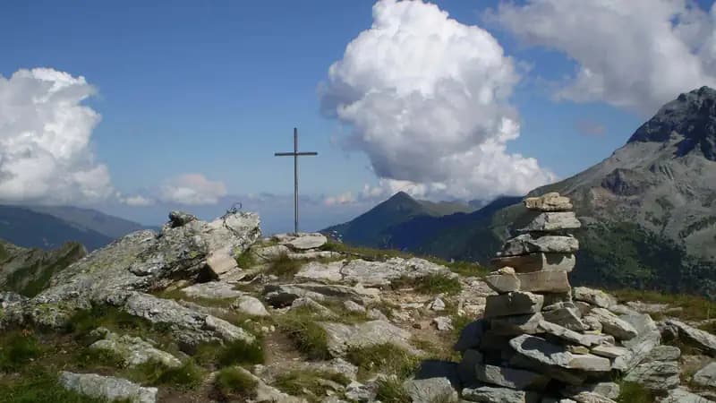
The second part of the Ferrata di Rocca Senghi presents similar characteristics, but with less pronounced overhangs and more slabby walls. After a horizontal traverse to the right, you pass through a characteristic hole in the rock. A few more minutes of vertical climbing and you gain the metal cross marking the summit of Rocca Senghi. The time to complete the ferrata is about 1 hour and 30 minutes, for a total of 2 hours and 30 minutes from the start of the hike.
The final section unfolds on more articulated rock, with passages that exploit cracks and chimneys. The pace remains athletic but the technical character softens slightly, becoming more panoramic and open, until the exit at the summit, the culminating point of the experience.
Descent
From the summit, descend to a small saddle where you encounter a junction. Turning right, a trail leads to the remains of the military shelter already glimpsed on the ascent. Choosing the left junction instead, you can descend through the military tunnel that crosses the mountain, emerging near the shelter. The tunnel, about 30 meters long, is initially equipped with metal steps and a cable, and a headlamp is essential for the crossing. From the shelter, descend along a trail that returns near the start of the ferrata, then retrace the approach trail back to the parking lot. The descent takes about one hour from the end of the ferrata, for a total of 3 hours and 30 minutes for the entire outing.
The descent introduces an element of variety, offering a speleological and historical option with the tunnel, which changes the pace of the outing. The return trail, though downhill, still requires attention due to the steepness of the gully, closing a route with a compact and logical progression.
Useful Notes
The ferrata cable is installed in the French style, meaning it is not particularly taut, which reduces the ability to easily pull yourself up on the most difficult sections. However, the notable abundance of stirrups and steps offers excellent support for both hands and feet throughout the progression, compensating for this characteristic.
This configuration imposes an active style of progression, based more on using artificial holds and footholds than on pulling on the cable. The result is a technical experience that evenly engages arm and leg strength, accentuating its athletic character. The compact rock and good maintenance of the anchors ensure safety along the entire route.
Track and weather
Plan the route
Preview the GPX track from the backend, download it for your GPS device, open parking directions, and check a short forecast before leaving.
Images
FAQ
What level of commitment does this via ferrata require?
ferrata.faqAnswers.commitment
How much elevation gain should I plan for?
The listed ferrata elevation gain is 230 m. Also consider approach, return and maximum altitude, because they can matter more than the equipped section alone.
Where is the route located?
Ferrata Rocca Senghi is located in Alpi Marittime, Cuneo, Italy. Before leaving, check parking, access and current local conditions.
When is the best time to climb it?
The best season depends on altitude, aspect and lingering snow. Avoid storms, wet rock and uncertain conditions; start early and keep a margin for the return.
Gear and safety planning
Use the technical data on this page to plan equipment, timing and offline navigation. For a general checklist, read the equipment guide before opening the route in the app.
Video
Watch the route
Useful YouTube videos for getting a real feel for the route before you go.
Logbook
Route condition reports
Recent community notes about closures, snow, equipment damage, trail issues and current conditions.
Community
Reviews, check-ins and photos
-
0 reviews
0
0 climbers
0
Shared by the community
Community photos
Recent images uploaded by Sferrati members.
No community photos yet
Open this route in the app to add the first photo.
Reviews
Recent impressions from climbers who know the route.
No reviews yet
Be the first to review this via ferrata from the app.
Continue in the app
Track the climb, save maps offline, and sync this route to your personal profile.
Use the app to climb
Offline maps, tracking, saves, and profile sync.
Scan the code before leaving, install the app, and keep your route data ready when reception fades.
