Overview
The Susatti Via Ferrata leading to the summit of Cima Capi is an ideal route for a first approach to the world of via ferratas. It is an accessible itinerary that requires no particular technical skills, yet offers good exposure in a spectacular setting, allowing you to gain confidence with safe progression. The low altitude and predominantly southeast exposure make the climb especially sunny and warm in the summer months-a factor to consider when planning. The route unfolds mainly along a sharp ridge, offering continuous, panoramic progression from the very start, in a typically pre-Alpine morphological context.
Approach
The starting point is the village of Biacesa, located about 4 kilometers from Riva del Garda. From Riva, drive through the tunnels toward Val di Ledro; after exiting the second tunnel, you quickly reach Biacesa. Here, take Via dei Dazi to the right, then turn right again at the end of the road. The hike begins near the playground, where parking is reserved for residents; you will need to find legal parking nearby.
From the starting area, follow CAI trail 470, also known as the Sentiero dei Bech, which proceeds at elevation eastward along the Valle del Gec. The well-marked trail winds with pleasant ups and downs through the typical Mediterranean vegetation of the Garda area, among olive and laurel trees, ignoring the left turn for the Sentiero Attrezzato delle Laste. After some easy, unroped rock steps, continue past a junction with CAI trail 405 for Riva del Garda, then ascend a straightforward chimney that leads to the start of the via ferrata. The approach time from the parking area is about 1 hour and 15 minutes. The approach offers a steady pace, gradually preparing you for the rocky environment ahead.
Via Ferrata
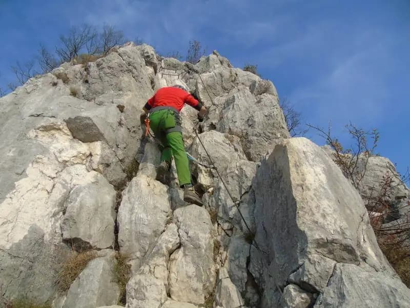
The start is marked by a red plaque, just beyond some unroped rock steps. From here, the steel cable begins, helping you ascend the first rocky steps inside a chimney. You then emerge onto the ridge, where the first passages begin-not difficult, but increasingly exposed. The climb continues over well-stepped limestone slabs, where it is often possible to move without constantly gripping the cable, making the route more physical than technical. You overcome a slab with the help of a couple of stirrups, then reach the ridge crest. In this section, you proceed on the right side of the ridge, in strong exposure, but without particular technical obstacles.
The via ferrata unfolds elegantly along the ridge itself, ascending boulders and small equipped walls. The progression is pleasant and continuous, with the view of Lake Garda gradually opening up behind you, offering breathtaking scenery. Finally, you reach the only passage of moderate difficulty: you skirt a large boulder with an exposed traverse, seeking holds around the edge. Past this point, you enter an easy chimney and, after a few short vertical sections, emerge onto the trail leading to the summit of Cima Capi (909 meters). The time to complete the via ferrata is about 1 hour and 15 minutes, for a total of 2 hours and 30 minutes from the start of the hike. The pace is steady but not rushed, with constant exposure that delivers an authentic ridge-progression experience.
Descent
From the summit, it is advisable not to remove your via ferrata gear, as you will encounter other equipped sections during the return, regardless of the option chosen. From Cima Capi, descend on the opposite side from the ascent, following an easy ridge trail near World War I trenches and a helicopter landing pad. In about 15 minutes, you reach a crucial junction.
Turning left takes you onto the Sentiero Attrezzato Foletti, which leads to the Bivacco Arcioni, then to the Chiesa di San Giovanni, and finally to Biacesa (about 1 hour and 30 minutes from Cima Capi, for a total of 4 hours). From Bivacco Arcioni, you can also opt for the descent along the more challenging Sentiero Attrezzato delle Laste, which reconnects with the CAI trail 470 approach path, to be retraced back to the parking area (total 4 hours). This is the shortest option for closing the loop.
Continuing straight at the junction, you follow the Sentiero Attrezzato Susatti toward Bocca d'Enzima (about 1 hour from Cima Capi). This trail, with easy equipped sections, runs along the hillside on a more wooded slope. From Bocca d'Enzima, take CAI 404 toward Rocchetta Giochello to a junction with CAI 417, which, via a long loop itinerary, returns to Biacesa (about 3 hours from Cima Capi, for a total of 5 hours and 30 minutes). The descent options offer different paces, from the continuity of the ridge to the more technical equipped side trails.
Useful Notes
The area of the Susatti Via Ferrata to Cima Capi is of great historical interest, rich in evidence of World War I, when Austrian troops were entrenched in these zones. Along the via ferrata and nearby trails, you can explore tunnels and trenches; it is therefore recommended to bring a headlamp. Trail markings are excellent.
This area of the Prealpi Giudicarie offers the possibility of combining the Susatti Via Ferrata with other equipped itineraries, such as the Sentiero Attrezzato Foletti and the Sentiero Attrezzato delle Laste, both doable as descents. From Bivacco Arcioni, if you still have energy, you can consider the ascent of Cima Rocca via its easy via ferrata. Nearby, though difficult to combine in the same day, you will also find the Ferrata dell'Amicizia at Cima Sat and, heading toward Trento, the Ferrata at Castel Drena or the easy equipped trails of Colodri and Cavre. The morphology of the area, with its ridges and ledges, favors the creation of a network of routes that develop horizontally or on gentle slopes, ideal for extending the experience safely.