
Sentiero Attrezzato delle Laste
Prealpi Giudicarie · Trento · Italy
Technical data
- Difficulty
- Facile
- Status
- aperta
- Distance
- 4 km
- Total duration
- 1 h 45 min
- Approach
- 15 min
- Ferrata time
- 45 min
- Elevation gain
- 231 m
- Max altitude
- 858 m
Route planning
How to plan Sentiero Attrezzato delle Laste
Sentiero Attrezzato delle Laste is in Prealpi Giudicarie, Trento, Italy and is rated Facile. Available route data lists about 1 h 45 min total time, 4 km of distance, 231 m of elevation gain.
For day planning, consider an approach of about 15 min, about 45 min on the cable, a maximum altitude near 858 m. Reported route features include: Interesse Storico, Galleria.
The page includes a parking or driving-directions reference. A GPX track is available to review and download.
As with every via ferrata, evaluate season, lingering snow, storms, crowds and equipment condition. Page last updated on 7/4/2026.
Features
Description
Overview
The Sentiero Attrezzato delle Laste is the most direct link between the village of Biacesa, in the Valle di Ledro, and the Bivacco Arcioni, with access to the panoramic little church of San Giovanni on the slopes of Cima Rocca and Cima Capi. This is a versatile route, doable either uphill or downhill, characterized by modest exposure and a straightforward progression, making it suitable for a wide range of hikers.
Approach
The route begins in Biacesa, a village reachable from Riva del Garda by driving about 4 kilometers toward the Val di Ledro through the tunnels. After exiting the second tunnel, you quickly enter the village. Here, take via dei Dazi on the right, then turn right again at the end of the street to reach a equipped area with a playground and parking lot-the actual starting point of the hike. From here, follow the CAI 470 trail marker (Sentiero dei Bech) eastward, toward Cima Capi and the Val de Gac. After about 15 minutes of walking, you come to a junction: leave trail 470 and take the CAI 471 route to the left, which leads in a few minutes to the start of the Sentiero Attrezzato delle Laste (reachable in a total of 15 minutes from the parking lot).
Via Ferrata
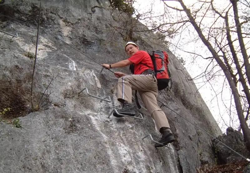
The equipped route begins with an easy dihedral about six meters high, featuring good natural holds on the right, while the safety cable runs on the left side. After overcoming this first obstacle, the path develops along a grassy ledge through the woods, quite wide and comfortable, leading to a subsequent diagonal ramp with well-stepped terrain and easy progression. The route continues to a short natural tunnel, where you can sign the summit register. Resuming the walk, you tackle a short equipped rock face with comfortably sized metal steps, followed by a second similar section but set diagonally. The fixed equipment ends along a final ledge. From this point, a well-marked but continuously ascending trail leads in about 45 minutes to the Bivacco Arcioni.
Descent
From the Church of San Giovanni, to complete the loop and return to Biacesa, take the CAI 460 trail westward. This descends until it intersects the CAI 417 route; at the junction, keep left to head directly toward the village. This descent section takes about 45 minutes from the end of the equipped trail, for a total loop time of about one hour and three-quarters.
Useful Notes
The Sentiero Attrezzato delle Laste is an ideal choice for a first approach to via ferratas, thanks to its modest technical difficulty, its generally horizontal progression along ledges, and the absence of exposed or airy sections. It is therefore particularly suitable for hikers with little experience on equipped trails. Its primary function is to quickly reach the Bivacco Arcioni and the San Giovanni area, and it can also serve as an access route for other challenging ferratas in the Alto Garda, such as the Ferrata di Cima Rocca or the Sentiero Attrezzato Foletti toward Cima Capi. For planning, it is advisable to consult a detailed map of the Alto Garda and Valle di Ledro area.
Track and weather
Plan the route
Preview the GPX track from the backend, download it for your GPS device, open parking directions, and check a short forecast before leaving.
Images
FAQ
What level of commitment does this via ferrata require?
ferrata.faqAnswers.commitment
How much elevation gain should I plan for?
The listed ferrata elevation gain is 231 m. Also consider approach, return and maximum altitude, because they can matter more than the equipped section alone.
Where is the route located?
Sentiero Attrezzato delle Laste is located in Prealpi Giudicarie, Trento, Italy. Before leaving, check parking, access and current local conditions.
When is the best time to climb it?
The best season depends on altitude, aspect and lingering snow. Avoid storms, wet rock and uncertain conditions; start early and keep a margin for the return.
Gear and safety planning
Use the technical data on this page to plan equipment, timing and offline navigation. For a general checklist, read the equipment guide before opening the route in the app.
Video
Watch the route
Useful YouTube videos for getting a real feel for the route before you go.
Logbook
Route condition reports
Recent community notes about closures, snow, equipment damage, trail issues and current conditions.
Community
Reviews, check-ins and photos
-
0 reviews
1
1 climbers
0
Shared by the community
Community photos
Recent images uploaded by Sferrati members.
No community photos yet
Open this route in the app to add the first photo.
Reviews
Recent impressions from climbers who know the route.
No reviews yet
Be the first to review this via ferrata from the app.
Continue in the app
Track the climb, save maps offline, and sync this route to your personal profile.
Use the app to climb
Offline maps, tracking, saves, and profile sync.
Scan the code before leaving, install the app, and keep your route data ready when reception fades.
