
Sentiero Attrezzato degli Alpini a Punta d'Albiolo
Punta d'Albiolo · Brescia · Italy
Technical data
- Difficulty
- Facile
- Status
- aperta
- Distance
- 11 km
- Total duration
- 4 h 45 min
- Approach
- 1 h 45 min
- Ferrata time
- 1 h 30 min
- Elevation gain
- 250 m
- Max altitude
- 2970 m
Route planning
How to plan Sentiero Attrezzato degli Alpini a Punta d'Albiolo
Sentiero Attrezzato degli Alpini a Punta d'Albiolo is in Punta d'Albiolo, Brescia, Italy and is rated Facile. Available route data lists about 4 h 45 min total time, 11 km of distance, 250 m of elevation gain.
For day planning, consider an approach of about 105 min, about 90 min on the cable, a maximum altitude near 2970 m. Reported route features include: Alta montagna, Interesse Storico.
The page includes a parking or driving-directions reference. A GPX track is not available yet, so bring an alternative map source.
As with every via ferrata, evaluate season, lingering snow, storms, crowds and equipment condition. Page last updated on 7/4/2026.
Features
Description
Overview
The Sentiero degli Alpini is a historic and scenic route linking Forcella del Montozzo to Passo dei Contrabbandieri in the Adamello-Presanella massif. It is more of a moderately difficult equipped trail than a true via ferrata. The steel cable is installed primarily for safety on exposed traverses and on sections where the ground, often damp, can become slippery. The route is described in the traditional direction, from Forcella del Montozzo toward Passo dei Contrabbandieri, but it can be traveled in either direction. The short detour to the summit of Torrione di Albiolo is optional but highly recommended for its exceptional panoramic value.
Approach
The most common starting point is Case di Viso (1754 m), in the province of Brescia, near Passo del Tonale. From here, take the well-marked trail number 52, which in about an hour and thirty minutes leads to Rifugio Bozzi (2478 m). Continuing along a further steep section lasting about twenty minutes, you reach Forcella del Montozzo (2613 m), which marks the actual start of the Sentiero degli Alpini. Alternative approaches exist: from the Trentino side of Pejo (Fontanino area) via trail 111, or directly from Passo del Tonale descending toward Passo dei Contrabbandieri, thus reversing the direction of the route.
Via Ferrata
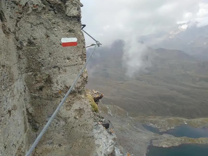
The route, which develops between 2613 and 2679 meters in altitude, is a fascinating historic walkway, characterized by exposed sections but generally on a wide path. Starting from Forcella del Montozzo, the trail immediately enters an environment rich in memory, crossing galleries and tunnels dug by the Alpini during World War I. The progression takes place on steep terrain and, in some spots, notably exposed; where the passages narrow, steel cables are present for support.
After the first equipped traverses, you cross a small saddle that offers a splendid view of the Albiolo lakes. The route then continues along ledges and exposed passages until reaching a marked junction. Turning left, a detour of a few minutes leads, via easy passages, first below the summit of Albiolino and then in front of Torrione di Albiolo (2976 m). For the final stretch of ascent to the summit cross, there is a short steel cable. Returning to the junction, you resume the actual Sentiero degli Alpini, which in about half an hour brings you to Passo dei Contrabbandieri (2679 m), recognizable by a ruined hut. The time for the entire equipped section, including the detour, is about an hour and thirty minutes. For those wishing to extend the hike, in less than thirty minutes from the pass you can climb to Cima Casaiole, rich in other wartime artifacts.
Route analysis: The route develops predominantly horizontally, with modest ups and downs, along a succession of ledges and walkways carved into the rock. The rock, granitic in nature, is solid and offers good footing. The pace is steady and pleasant, with exposure felt especially on the traverses, balanced however by the generally good width of the path. The character is more hiking than mountaineering, with a strong historical and scenic component prevailing over the technical one. The detour to Torrione introduces a short, more vertical and decidedly panoramic section that breaks the linearity of the main route.
Descent
The quickest way back from Passo dei Contrabbandieri descends north toward Rifugio Bozzi, reachable in twenty to thirty minutes. From there, return to Case di Viso following the approach trail in about an hour and fifteen minutes. The total time for the excursion thus comes to around five hours.
Useful Notes
This ledge route is only practicable in the absence of snow, ideally in the summer season between June and September. Wet ground can become treacherous, especially in spots without a cable. The equipment was renewed in August 2019 and is in excellent condition, except for a few non-hazardous pitons. The Sentiero degli Alpini can form the first part of a more challenging itinerary that continues with the Ferrata degli Austriaci toward Tonale Orientale. The Passo del Tonale area is rich in other mountaineering options, such as the famous Sentiero dei Fiori. For cartography, the 4Land map of Adamello and Presanella is recommended.
Track and weather
Plan the route
Preview the GPX track from the backend, download it for your GPS device, open parking directions, and check a short forecast before leaving.
GPX track unavailable
This route does not include a downloadable track yet.
Images
FAQ
What level of commitment does this via ferrata require?
ferrata.faqAnswers.commitment
How much elevation gain should I plan for?
The listed ferrata elevation gain is 250 m. Also consider approach, return and maximum altitude, because they can matter more than the equipped section alone.
Where is the route located?
Sentiero Attrezzato degli Alpini a Punta d'Albiolo is located in Punta d'Albiolo, Brescia, Italy. Before leaving, check parking, access and current local conditions.
When is the best time to climb it?
The best season depends on altitude, aspect and lingering snow. Avoid storms, wet rock and uncertain conditions; start early and keep a margin for the return.
Gear and safety planning
Use the technical data on this page to plan equipment, timing and offline navigation. For a general checklist, read the equipment guide before opening the route in the app.
Video
Watch the route
Useful YouTube videos for getting a real feel for the route before you go.
Logbook
Route condition reports
Recent community notes about closures, snow, equipment damage, trail issues and current conditions.
Community
Reviews, check-ins and photos
-
0 reviews
0
0 climbers
0
Shared by the community
Community photos
Recent images uploaded by Sferrati members.
No community photos yet
Open this route in the app to add the first photo.
Reviews
Recent impressions from climbers who know the route.
No reviews yet
Be the first to review this via ferrata from the app.
Continue in the app
Track the climb, save maps offline, and sync this route to your personal profile.
Use the app to climb
Offline maps, tracking, saves, and profile sync.
Scan the code before leaving, install the app, and keep your route data ready when reception fades.
