
Sentiero Attrezzato della Direttissima
Prealpi Bergamasche · Lecco · Italy
Technical data
- Difficulty
- Moderatamente Difficile
- Status
- aperta
- Distance
- 10 km
- Total duration
- 6 h
- Approach
- 45 min
- Ferrata time
- 2 h 30 min
- Elevation gain
- 600 m
- Max altitude
- 2177 m
Route planning
How to plan Sentiero Attrezzato della Direttissima
Sentiero Attrezzato della Direttissima is in Prealpi Bergamasche, Lecco, Italy and is rated Moderatamente Difficile. Available route data lists about 6 h total time, 10 km of distance, 600 m of elevation gain.
For day planning, consider an approach of about 45 min, about 150 min on the cable, a maximum altitude near 2177 m. Reported route features include: Scale, Itinerario lungo.
The page includes a parking or driving-directions reference. A GPX track is available to review and download.
As with every via ferrata, evaluate season, lingering snow, storms, crowds and equipment condition. Page last updated on 7/4/2026.
Features
Description
Overview
The Direttissima equipped path offers one of the most spectacular and rewarding traverses in the entire Alpine environment. This route to the summit of Grignetta does not feature extreme climbing passages, being equipped with metal protections on the most challenging sections, and guarantees an exceptional view of the spires and pinnacles that characterize the Grigne group. The final destination of the Direttissima constitutes a crucial hiking junction, from which numerous variants depart for exploring further routes of the massif.
Approach
The start is from the Piani dei Resinelli, in the province of Lecco. From Ballabio, ascend along the left side following a road with many switchbacks; after passing a large brown signpost, continue climbing for another switchback. At the next fork, keep left, taking a narrow paved road to a parking area marked by a barrier. From here, a short trail leads in five minutes to the Rifugio Carlo Porta. Then take Sentiero 8, which climbs through dense forest vegetation. About thirty minutes from the parking area, you reach a junction: to the right, the Cresta Cermenati and Cresta Sinigaglia branch off (possible return routes), while you continue left for the Direttissima. The trail skirts a wide gully and continues on a path that becomes progressively steeper, up to the start of the first rock face equipped with chains.
Via Ferrata
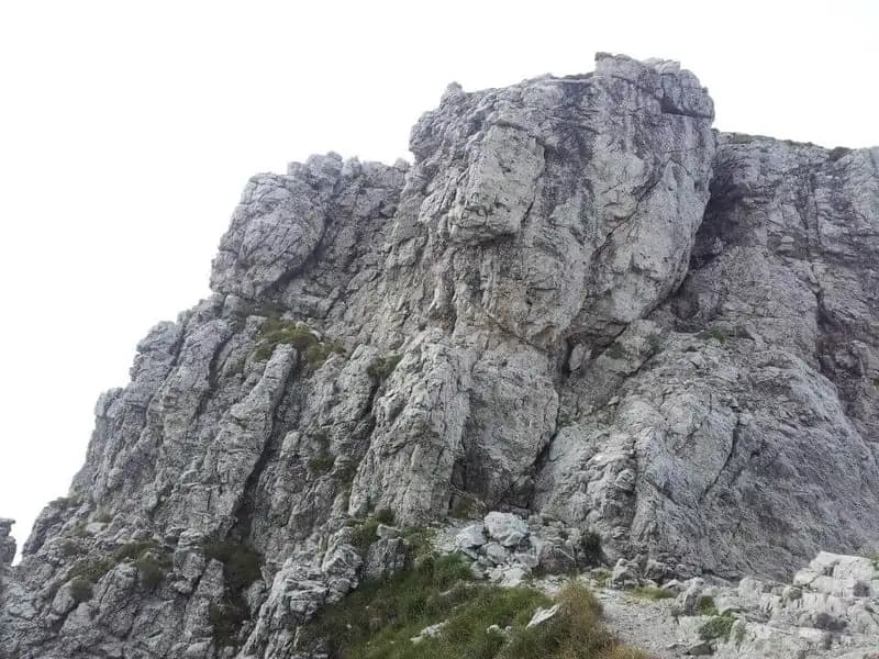
The route initially develops on rocky spurs, where progression often occurs diagonally and you can use the rock directly for climbing, without necessarily having to use the steel cable. You overcome several rock steps with the aid of a fixed rope, then tackle an exposed traverse equipped with foot stirrups. The morphology changes radically when you enter a rocky gully, characterized by several ledges to overcome. The ascent continues up the Caminetto Pagani, aided by two metal ladders: the first is overhanging, while the second rests against the rock. After the second ladder, you pass through the narrow chimney passage, where it's wise to be careful with overly bulky backpacks.
The route continues with a series of ups and downs through a labyrinth of spectacular spires, ignoring the junctions you encounter. In this section, you find the deviation for Sentiero 8a (Sentiero Giorgio), which leads to Rifugio Rosalba. Continuing straight, you arrive at a junction near Canalone Angelina. At this point, two options present themselves.
Continuing on the main Direttissima route, you later merge into the upper part of Sentiero Cecilia, after ascending toward Colle Valsecchi. This section includes some equipped passages on a sloping wall and lateral progression along a gully. Once at Colle Valsecchi, you can opt for the Sentiero Attrezzato Cecilia (described in the following alternative) or keep left toward Val Scarettone. At the next junction, continue left toward Val Scarettone and Canalino Federazione. You then traverse a deep valley, with several equipped sections and majestic spires towering above you. You exit the valley at Bocchetta del Giardino; after an open trail section, you find yourself at the base of the narrow and steep canalino Federazione, which you ascend following red markers. The final obstacle is a last wall, somewhat exposed but equipped with chains, which leads to the summit of Grignetta, where the characteristic bivouac is located. The total time for this option is approximately 3 hours and 45 minutes.
The second option is to continue ascending in Canalone Angelina, merging directly into the upper part of Sentiero Attrezzato Cecilia (the same point you would reach from Colle Valsecchi by choosing the Cecilia). The Sentiero Cecilia is a challenging and rocky itinerary, developing mainly on traverses and equipped walls. The most complex passage is the descent inside a rocky gully with a chain. Continue on the Cecilia until it joins the more comfortable Cresta Cermenati, which leads to the summit of Grigna Meridionale in about 3 hours and 30 minutes total.
Descent
The main descent routes are two. The first, wider and more frequented, is the descent via Cresta Cermenati: a steep and in places slippery path, but not difficult, which returns to the parking area in about 1 hour and 45 minutes from the summit (for a total of about 5 hours and 15 minutes). The second option, a bit more daring, is the descent via the Sentiero Attrezzato della Cresta Sinigaglia, which features some exposed and equipped sections. Along the Cresta Sinigaglia, you can also take junction 3 for the Canalone Porta.
Useful Notes
The Direttissima is classified as a route for Expert Hikers (EE) and, for many experienced mountaineers, the cable primarily serves as a handrail. However, it is essential never to skimp on safety: some sections, due to their exposure, deserve to be considered on par with an Expert Hikers with Equipment (EEA) route. A possible alternative for the descent, longer and more strenuous but very rewarding, involves descending first via the Sentiero Attrezzato Cecilia and then, from Rifugio Rosalba, via the Sentiero Attrezzato delle Foppe or the Sentiero Attrezzato dei Morti. This loop, lasting about 8 hours, requires stable weather conditions, as the Sentiero Cecilia includes some exposed unprotected passages.
Track and weather
Plan the route
Preview the GPX track from the backend, download it for your GPS device, open parking directions, and check a short forecast before leaving.
Images
FAQ
What level of commitment does this via ferrata require?
ferrata.faqAnswers.commitment
How much elevation gain should I plan for?
The listed ferrata elevation gain is 600 m. Also consider approach, return and maximum altitude, because they can matter more than the equipped section alone.
Where is the route located?
Sentiero Attrezzato della Direttissima is located in Prealpi Bergamasche, Lecco, Italy. Before leaving, check parking, access and current local conditions.
When is the best time to climb it?
The best season depends on altitude, aspect and lingering snow. Avoid storms, wet rock and uncertain conditions; start early and keep a margin for the return.
Gear and safety planning
Use the technical data on this page to plan equipment, timing and offline navigation. For a general checklist, read the equipment guide before opening the route in the app.
Video
Watch the route
Useful YouTube videos for getting a real feel for the route before you go.
Logbook
Route condition reports
Recent community notes about closures, snow, equipment damage, trail issues and current conditions.
Community
Reviews, check-ins and photos
-
0 reviews
0
0 climbers
0
Shared by the community
Community photos
Recent images uploaded by Sferrati members.
No community photos yet
Open this route in the app to add the first photo.
Reviews
Recent impressions from climbers who know the route.
No reviews yet
Be the first to review this via ferrata from the app.
Continue in the app
Track the climb, save maps offline, and sync this route to your personal profile.
Use the app to climb
Offline maps, tracking, saves, and profile sync.
Scan the code before leaving, install the app, and keep your route data ready when reception fades.
