
Ferrata del Pizzo Badile Camuno
Pizzo Badile Camuno · Brescia · Italy
Technical data
- Difficulty
- Difficile
- Status
- aperta
- Distance
- 10 km
- Total duration
- 6 h 30 min
- Approach
- 3 h
- Ferrata time
- 30 min
- Elevation gain
- 1385 m
- Max altitude
- 2435 m
Route planning
How to plan Ferrata del Pizzo Badile Camuno
Ferrata del Pizzo Badile Camuno is in Pizzo Badile Camuno, Brescia, Italy and is rated Difficile. Available route data lists about 6 h 30 min total time, 10 km of distance, 1385 m of elevation gain.
For day planning, consider an approach of about 180 min, about 30 min on the cable, a maximum altitude near 2435 m. Reported route features include: Itinerario lungo.
The page includes a parking or driving-directions reference. A GPX track is available to review and download.
As with every via ferrata, evaluate season, lingering snow, storms, crowds and equipment condition. Page last updated on 7/4/2026.
Features
Description
Overview
The Ferrata al Pizzo Badile Camuno is a deeply rewarding alpine route, unfolding on one of the southern peaks of the Adamello Group in the upper Val Camonica of Brescia. The overall itinerary is demanding, characterized by a long approach and an equally lengthy return, while the actual equipped section does not present particularly high technical difficulties. The effort and considerable elevation gain are amply compensated by the magnificent panoramic view from the summit.
The route has a decidedly alpine character: despite the moderate altitude, its length, isolation, and the nature of the passages place it among the most complete and physically significant offerings in the area. The goal is clearly the conquest of the summit, pursued through a logical and traditional ascent.
Approach
The starting point is located near Cimbergo, in upper Val Camonica. From the village, take a road on the right marked for Volano and Redole. Follow this track, initially paved and in decent condition, ignoring secondary junctions until it turns into a dirt road. It is advisable to park here; proceeding cautiously toward a wider area further on, the surface becomes progressively rougher. From this point, begin the approach on foot along the dirt road, which coincides with the CAI trail 16, up to the Rifugio De Marie.
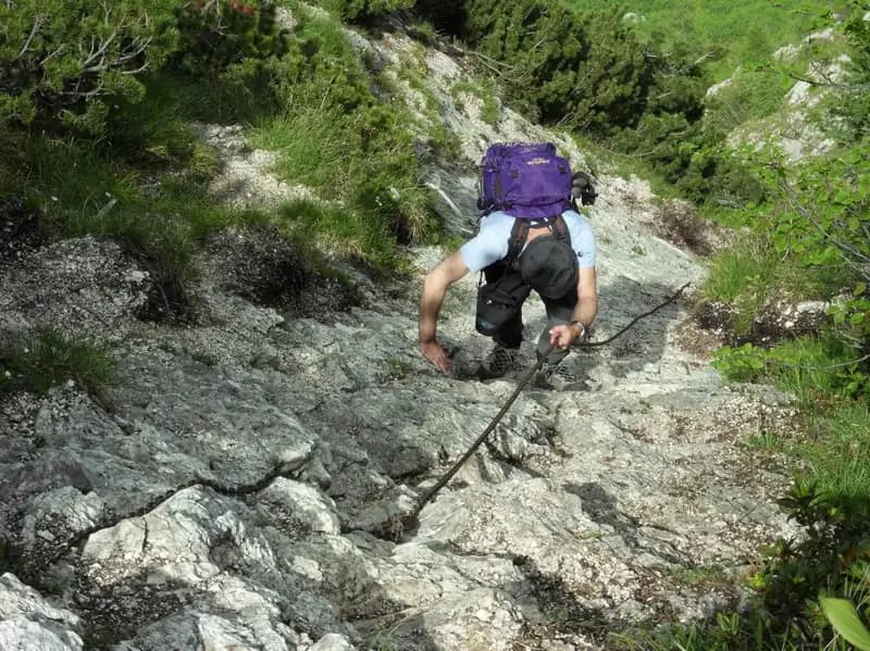
From the refuge, leave trail 16 and take the well-marked CAI trail 77 to the right. The path climbs steeply through the woods, and after about half an hour, you encounter the first short equipped sections: a fairly low-angle slab fitted with a cable that is not always taut. Follow the red-and-white markers along a steep trail, slippery in places, overcoming a few rock steps and boulders with the aid of stirrups, until you exit the forest. Continuing among the blocks, you reach a second equipped section with a cable: this is a low-angle wall about 30-40 meters long, whose ascent is not trivial due to the scarcity of natural holds and sections where the cable is loose. The pace of the approach is therefore uneven, alternating between forest walking and brief but intense technical passages on rock.
Continuing on the ascending trail, you arrive near a bivouac shelter. From here, an exposed trail, partly equipped, proceeds traversing with easy but airy passages, finally leading to the start of the Ferrata al Pizzo Badile Camuno. The approach from the parking area takes about 2 hours and 30 minutes. The environment evolves progressively: from dense vegetation to open slopes, with the trail developing along ledges and gullies, a prelude to the more vertical terrain of the via ferrata.
Via Ferrata
The equipped route begins by ascending a fairly low-angle wall, where it is possible to climb for most of the section. The ascent is pleasant and logical, with the cable often serving as a useful handrail and balance point. After a straightforward stretch, it bends slightly to the right onto a comfortable and scenic ascending ledge. From this vantage point, the cable resumes climbing more vertically, first to the right and then to the left, on very stable rock, proceeding mainly diagonally. After a few minutes, you reach another small terrace with expansive views.
The route unfolds on solid, compact rock, typical of the area, with a varied rhythm: it alternates between nearly horizontal sections on ledges and diagonal climbs across slabs, maintaining continuous but manageable exposure. From this point, the steepness increases: you ascend a couple of steeper but still low-angle walls, then tackle a vertical wall that climbs a shallow gully. Bearing to the right, you mount a few rock steps on the ridge, beyond which the metal equipment ends. You now find yourself on the broad summit ridge, which you follow until you reach the Madonnina just below the summit at 2435 meters, the endpoint of the via ferrata. The time for the equipped route is about 30 minutes from the start, for a total of 3 hours and 30 minutes from the departure.
The experience is predominantly scenic and involves continuous climbing, with a character that is more physical than technical. The via ferrata is not aimed at pure difficulty grade, but at leading elegantly and safely to the summit, following the mountain's natural lines.
Descent
The return is via the same route as the ascent. You must pay close attention both when descending the via ferrata sections and on the rocky passages of the approach. This is a long itinerary, with a demanding descent that must be factored into energy management. The descent time from the summit is about 2 hours and 45 minutes, for a total of 6 hours and 30 minutes for the entire loop.
The descent retraces all the passages in reverse, requiring particular care when downclimbing the equipped sections and on the slippery segments in the forest. The return is physically draining, especially due to the overall length and prolonged exposure.
Useful Notes
The Ferrata al Pizzo Badile Camuno is a traditional-style route, with few fixed metal aids, a logical ascent not focused on pure difficulty grade, and the goal of reaching a summit. It takes place in a beautiful setting and, despite the not-very-high altitude, has the character of a difficult alpine excursion. The approach and return feature several challenging and exposed sections; some passages in the woods require climbing and downclimbing skills at Grade I. That said, from a purely technical standpoint, the via ferrata presents no significant difficulties. From the summit, you enjoy a stunning panorama of the Adamello Group, with views also of the more distant Disgrazia Group and Volano.
The itinerary therefore requires good physical fitness, experience in alpine terrain, and familiarity with exposure. The satisfaction comes from the completeness of the route, which combines a long and varied approach with a spacious ridge climb.
Track and weather
Plan the route
Preview the GPX track from the backend, download it for your GPS device, open parking directions, and check a short forecast before leaving.
Images
FAQ
What level of commitment does this via ferrata require?
ferrata.faqAnswers.commitment
How much elevation gain should I plan for?
The listed ferrata elevation gain is 1385 m. Also consider approach, return and maximum altitude, because they can matter more than the equipped section alone.
Where is the route located?
Ferrata del Pizzo Badile Camuno is located in Pizzo Badile Camuno, Brescia, Italy. Before leaving, check parking, access and current local conditions.
When is the best time to climb it?
The best season depends on altitude, aspect and lingering snow. Avoid storms, wet rock and uncertain conditions; start early and keep a margin for the return.
Gear and safety planning
Use the technical data on this page to plan equipment, timing and offline navigation. For a general checklist, read the equipment guide before opening the route in the app.
Video
Watch the route
Useful YouTube videos for getting a real feel for the route before you go.
Logbook
Route condition reports
Recent community notes about closures, snow, equipment damage, trail issues and current conditions.
Community
Reviews, check-ins and photos
-
0 reviews
0
0 climbers
0
Shared by the community
Community photos
Recent images uploaded by Sferrati members.
No community photos yet
Open this route in the app to add the first photo.
Reviews
Recent impressions from climbers who know the route.
No reviews yet
Be the first to review this via ferrata from the app.
Continue in the app
Track the climb, save maps offline, and sync this route to your personal profile.
Use the app to climb
Offline maps, tracking, saves, and profile sync.
Scan the code before leaving, install the app, and keep your route data ready when reception fades.
