
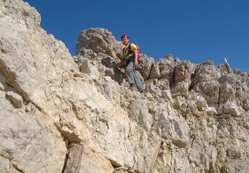
Ferrata Formenton alla Tofana di Dentro
Tofana di Dentro · Belluno · Italy
Technical data
- Difficulty
- Moderatamente Difficile
- Status
- aperta
- Distance
- 4,4 km
- Total duration
- 4 h 30 min
- Approach
- 10 min
- Ferrata time
- 1 h 15 min
- Elevation gain
- 400 m
- Max altitude
- 3221 m
Route planning
How to plan Ferrata Formenton alla Tofana di Dentro
Ferrata Formenton alla Tofana di Dentro is in Tofana di Dentro, Belluno, Italy and is rated Moderatamente Difficile. Available route data lists about 4 h 30 min total time, 4,4 km of distance, 400 m of elevation gain.
For day planning, consider an approach of about 10 min, about 75 min on the cable, a maximum altitude near 3221 m. Reported route features include: Alta montagna, Funivia all'andata, Funivia al ritorno, Interesse Storico.
The page includes a parking or driving-directions reference. A GPX track is available to review and download.
As with every via ferrata, evaluate season, lingering snow, storms, crowds and equipment condition. Page last updated on 7/4/2026.
Features
Description
Overview
The Ferrata del Formenton is a connecting route between Tofana di Mezzo and Tofana di Dentro in the Ampezzane Dolomites. It is a relatively short itinerary with a huge scenic impact, unfolding entirely in a high-altitude environment and offering sweeping views over the Conca Ampezzana, the Fanes group, and the Sexten Dolomites. From a technical standpoint, it is considered the most approachable of the via ferratas in the Tofane massif, though the severe terrain and near-constant exposure demand proper preparation and a respectful approach. 2023 update: the extension toward Tofana Terza is currently closed due to a landslide under observation; only the connection between Tofana di Mezzo and Tofana di Dentro is passable, with the return along the same equipped route.
Approach
The most direct access is from the valley station of the Freccia nel Cielo cable car in Cortina d'Ampezzo. Two sections take you up to the slopes of the summit of Tofana di Mezzo (3190 m). To save on costs, you can park at Baita Piè Tofana, take the chairlift up to Col Druscè, and continue on foot to the top station. Well-trained hikers can opt to combine the Ferrata Formenton with the Ferrata Olivieri at Punta Anna and the Ferrata Aglio, starting from Baita Piè Tofana and climbing to Rifugio Pomedes. From the cable car's top station, an easy trail leads toward the summit of Tofana di Mezzo; just before the top, a marking on the rock on the right indicates the start of the via ferrata (about 10 minutes from the cable car arrival).
Via Ferrata
The route begins with a short equipped section of a few meters, after which you move onto the northwest side of Tofana di Mezzo. The view opens up onto the ridge to descend toward Forcella della Tofana. The descent section is steep and constantly exposed, unfolding as a sequence of long ledge walks, short vertical sections of modest difficulty, and horizontal traverses. The itinerary often runs just below the ridge line, with technically simple passages that nonetheless require concentration due to the airy environment. You reach the Forcella della Tofana at 3085 meters in about 30 minutes from the start. Here you encounter a junction: to the left, a gully branches off for a descent toward Rifugio Giussani (1 hour), while the main route continues climbing toward Tofana di Dentro.
From the forcella, after a short descent on the northeast side, the ascending phase begins. More challenging short vertical sections, sloping ramps, and ledge sections alternate. The climb unfolds for long stretches along an exposed ridge crest, well equipped with cables and good natural holds. Later, the route drops slightly onto the right (eastern) side of the ridge, crossing some unsecured trail sections that lack exposure. With the final fixed cables in sight, you reach without particular difficulty the small summit cross of Tofana di Dentro at 3238 meters. The total time from the start is about 1 hour and 15 minutes (1 hour and 30 minutes from the cable car's top station).
Descent
The return is made via a wide loop. You initially descend along the debris slope of the northeast ridge, steep but with a clear track and cairns. You reach the distinctive Bivacco degli Alpini at 2922 meters, a potential emergency shelter. Continuing the descent on the northeast side, caution is needed in some spots due to unstable debris. Upon reaching a saddle, you turn right (south-southeast direction) for a rather exposed and unsecured section, to be tackled with care.
Continuing down, you encounter a singular rock formation shaped like a natural doorway, which opens the view onto Rifugio Ra Vales. You then pass the ruins of World War I structures and shelters. The trail becomes less steep until a junction with trail 407: keeping right, you head toward Rifugio Ra Vales at 2470 meters, the endpoint of the hike. From here, you can use the cable car to return to the valley. The descent from the summit takes about 3 hours, for a total itinerary time of about 4 hours and 30 minutes.
Useful Notes
The Ferrata Formenton is technically easy, with occasional passages of modest difficulty. The objective difficulty lies in the very high altitude (constantly above 3000 meters) and the continuous exposure, elements that can intimidate less experienced climbers. It is essential to undertake the itinerary only in stable weather conditions, also considering the length of the return. Early in the season, some sections of the descent trail may have residual snow or ice. For maps, detailed maps of the Cortina area and the Ampezzo Dolomites are recommended.
The itinerary can be combined with other via ferratas of the Tofane for more challenging traverses, such as the Ferrata Olivieri and the Ferrata Aglio. In the area around Rifugio Pomedes and Rifugio Ra Vales, other equipped routes also branch off, such as the Sentiero Attrezzato Olivieri, the Sentiero Astaldi, and the ferratas Ra Pegna and Ra Bujela. Toward Passo Falzarego, you'll find the Ferrata Tomaselli, the Ferrata Fusetti at Sass de Stria, the Ferrata at Col dei Bos, and the one at Averau.
Track and weather
Plan the route
Preview the GPX track from the backend, download it for your GPS device, open parking directions, and check a short forecast before leaving.
Images
FAQ
What level of commitment does this via ferrata require?
ferrata.faqAnswers.commitment
How much elevation gain should I plan for?
The listed ferrata elevation gain is 400 m. Also consider approach, return and maximum altitude, because they can matter more than the equipped section alone.
Where is the route located?
Ferrata Formenton alla Tofana di Dentro is located in Tofana di Dentro, Belluno, Italy. Before leaving, check parking, access and current local conditions.
When is the best time to climb it?
The best season depends on altitude, aspect and lingering snow. Avoid storms, wet rock and uncertain conditions; start early and keep a margin for the return.
Gear and safety planning
Use the technical data on this page to plan equipment, timing and offline navigation. For a general checklist, read the equipment guide before opening the route in the app.
Video
Watch the route
Useful YouTube videos for getting a real feel for the route before you go.
Logbook
Route condition reports
Recent community notes about closures, snow, equipment damage, trail issues and current conditions.
Community
Reviews, check-ins and photos
-
0 reviews
0
0 climbers
0
Shared by the community
Community photos
Recent images uploaded by Sferrati members.
No community photos yet
Open this route in the app to add the first photo.
Reviews
Recent impressions from climbers who know the route.
No reviews yet
Be the first to review this via ferrata from the app.
Continue in the app
Track the climb, save maps offline, and sync this route to your personal profile.
Use the app to climb
Offline maps, tracking, saves, and profile sync.
Scan the code before leaving, install the app, and keep your route data ready when reception fades.
