
Ferrata Bianchi al Cristallo
Cima del Cristallo di Mezzo · Belluno · Italy
Technical data
- Difficulty
- Moderatamente Difficile
- Status
- aperta
- Distance
- 7 km
- Total duration
- 7 h
- Approach
- 2 h 30 min
- Ferrata time
- 1 h 30 min
- Elevation gain
- 222 m
- Max altitude
- 3154 m
Route planning
How to plan Ferrata Bianchi al Cristallo
Ferrata Bianchi al Cristallo is in Cima del Cristallo di Mezzo, Belluno, Italy and is rated Moderatamente Difficile. Available route data lists about 7 h total time, 7 km of distance, 222 m of elevation gain.
For day planning, consider an approach of about 150 min, about 90 min on the cable, a maximum altitude near 3154 m. Reported route features include: Alta montagna, Scale, Itinerario lungo.
The page includes a parking or driving-directions reference. A GPX track is available to review and download.
As with every via ferrata, evaluate season, lingering snow, storms, crowds and equipment condition. Page last updated on 7/4/2026.
Features
Description
Overview
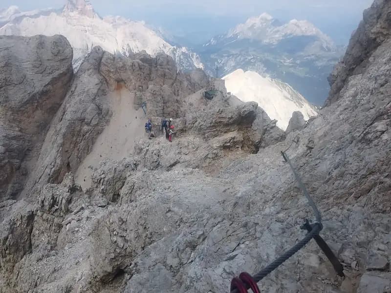
The Ferrata Marino Bianchi is a classic and spectacular route to the summit of Cristallo di Mezzo, starting from Passo delle Tre Croci. The closure of the historic Val de Stounies cable car has transformed the outing, making the approach and return longer and more physically demanding. The route winds along an articulated and exposed ridge, offering a full 360-degree panorama of the Zoldo, Ampezzane, Sesto, and Bellunesi Dolomites, which encircle the entire Cristallo massif.
Approach
The route begins at Passo delle Tre Croci, between Misurina and Cortina d'Ampezzo. From the parking area at the pass, you tackle the roughly 400-meter elevation gain on foot that leads to Rifugio Son Forca. Alternatively, you can take the chairlift that connects the main road to the refuge, but be sure to check the operating hours carefully. The pedestrian access follows the CAI trail 203 northwest, a route with a steady gradient that reaches Rifugio Son Forca at 2047 meters. The terrain changes dramatically beyond the refuge: you ascend a vast and tiring scree slope, orienting yourself by the poles of the disused cable car, up to Forcella Stounies at 2932 meters. The environment is severe, dominated by debris and rock walls. The entire approach takes about 2 hours and 30 minutes from the parking area, with a continuous and sustained pace that prepares you for the elevation challenge ahead.
Via Ferrata
Description in preparation.
Descent
From the summit cross of Cristallo di Mezzo, descend short rock steps and then take a left onto a red-marked trail. This path leads to a ledge that initially drops steeply, then climbs back up toward a notch. At this junction, you can choose to retrace the Ferrata Bianchi in descent or continue on the main trail. The latter option develops an alternative route along exposed ledges and steep gullies, with constant ups and downs, until it definitively rejoins the ascent route. From here, the descent retraces the approach itinerary back to the parking area. The descent time from the summit is about 3 hours, for a total of roughly 7 hours for the entire excursion. The pace is variable, with technical sections concentrated on the ledge traverses and long stretches of hiking over scree.
Useful Notes
At Forcella Staunies stands Rifugio Lorenzi, which, following the closure of the cable car, is currently unstaffed and offers only a self-service winter room. During the descent, it is essential to pay attention to the ledges, which are often subject to residual snow even late in the season. For maps, we recommend those dedicated to the Dolomites of Ampezzo and Sesto. The via ferrata is named after the Ampezzo mountain guide Marino Bianchi. Another famous route in the group is the Sentiero Attrezzato Dibona, but combining it with the Bianchi in a single day is no longer feasible without the cable car, now requiring an overnight stay in a bivouac.
Track and weather
Plan the route
Preview the GPX track from the backend, download it for your GPS device, open parking directions, and check a short forecast before leaving.
Images
FAQ
What level of commitment does this via ferrata require?
ferrata.faqAnswers.commitment
How much elevation gain should I plan for?
The listed ferrata elevation gain is 222 m. Also consider approach, return and maximum altitude, because they can matter more than the equipped section alone.
Where is the route located?
Ferrata Bianchi al Cristallo is located in Cima del Cristallo di Mezzo, Belluno, Italy. Before leaving, check parking, access and current local conditions.
When is the best time to climb it?
The best season depends on altitude, aspect and lingering snow. Avoid storms, wet rock and uncertain conditions; start early and keep a margin for the return.
Gear and safety planning
Use the technical data on this page to plan equipment, timing and offline navigation. For a general checklist, read the equipment guide before opening the route in the app.
Video
Watch the route
Useful YouTube videos for getting a real feel for the route before you go.
Logbook
Route condition reports
Recent community notes about closures, snow, equipment damage, trail issues and current conditions.
Community
Reviews, check-ins and photos
-
0 reviews
0
0 climbers
0
Shared by the community
Community photos
Recent images uploaded by Sferrati members.
No community photos yet
Open this route in the app to add the first photo.
Reviews
Recent impressions from climbers who know the route.
No reviews yet
Be the first to review this via ferrata from the app.
Continue in the app
Track the climb, save maps offline, and sync this route to your personal profile.
Use the app to climb
Offline maps, tracking, saves, and profile sync.
Scan the code before leaving, install the app, and keep your route data ready when reception fades.
