
Ferrata Gole del Serra
Appenino Umbro Marchigiano · Terni · Italy
Technical data
- Difficulty
- Moderatamente Difficile
- Status
- aperta
- Distance
- 2,5 km
- Total duration
- 3 h
- Approach
- 1 h
- Ferrata time
- 1 h 15 min
- Elevation gain
- 40 m
- Max altitude
- 280 m
Route planning
How to plan Ferrata Gole del Serra
Ferrata Gole del Serra is in Appenino Umbro Marchigiano, Terni, Italy and is rated Moderatamente Difficile. Available route data lists about 3 h total time, 2,5 km of distance, 40 m of elevation gain.
For day planning, consider an approach of about 60 min, about 75 min on the cable, a maximum altitude near 280 m. Reported route features include: Ponti sospesi, Scale, Galleria.
The page includes a parking or driving-directions reference. A GPX track is available to review and download.
As with every via ferrata, evaluate season, lingering snow, storms, crowds and equipment condition. Page last updated on 7/4/2026.
Features
Description
Overview
This technically easy via ferrata offers a unique experience in the Italian context. Its distinctive character lies in progressing through a narrow gorge-an environment typically explored by canyoning specialists-made accessible thanks to a series of artificial aids. The approach itself, which demands adaptability and a spirit of adventure, contributes to the itinerary's atmosphere. The spectacular nature of the confined, damp spaces of the gorge more than compensates for the logistical effort required to reach it. To fully appreciate the evocative quality of the place, with the play of light filtering into the gorge, an early morning start is recommended. The reference location is Rocca San Zenone, in the province of Terni.
The route develops predominantly horizontally, following the course of the gorge. The experience is more about ambiance and exploration than pure mountaineering, characterized by continuous progression over wet rock polished by water, with technical sections concentrated in the artificial tunnels. Exposure is generally limited, replaced by a feeling of immersion in a closed, evocative environment.
Approach
The route begins along the SP 67, about 2.5 kilometers downstream from Rocca San Zenone, at a wide, sharp left-hand curve. Here you'll find a dirt parking area suitable for parking, near an abandoned building. From the parking area, take the dirt track that descends steeply to the right, following the CAI markers. Cross a bridge over the railway line and continue along the path to the right, keeping the watercourse on your left and the tracks on your right. From this point, you need to carefully descend toward the riverbed, locating a passage that is not always clearly marked. Once you reach the stream, begin an ascent of the riverbed that lasts about thirty minutes.
This approach section is an integral part of the adventure: the gorge's morphology gradually becomes narrower and more enclosed. Progress is over pebbles and limestone slabs, often precariously balanced, with riparian vegetation occasionally obstructing the way. A pair of sturdy work gloves and a pair of pruning shears can prove useful for clearing the path. The start of the via ferrata is found near the entrance to a tunnel that passes under the railway embankment. The total approach time from the parking area is roughly one hour, varying depending on the stream's flow and the state of the vegetation.
Via Ferrata
The equipped route begins inside a first system of tunnels carved into the rock. The second tunnel, out of three total, presents the most challenging progression: it is a narrow, low passage where progress is aided by metal steps fixed into the wall. Emerging from this claustrophobic section, the climb continues over constantly damp, moss-covered rock-a stretch requiring maximum caution due to the extremely slippery surface.
The ferrata then winds through the narrowest heart of the gorge, alternating short sections of steel cable with ladders and metal rungs. The rock, limestone shaped by water, features natural ledges and chimneys that the route exploits. Progression is rhythmic and continuous, without major elevation gain but demanding constant attention to footholds. After about one hour and fifteen minutes from the start (roughly two hours and fifteen minutes from the parking area), you reach a point clearly marked by prominent blue paint marks. Here there is a junction: you can end the hike by climbing up toward the provincial road with the help of some ropes, or continue along the stream for the longer, more complete itinerary.
Descent
From the blue marks, climbing the ropes that lead out of the gorge, you emerge onto the edge of the paved road. From here, walk back up along the roadside toward the parking area. The total time for the standard route, including approach, ferrata, and return, is about three hours.
Useful Notes
The choice of season radically conditions the nature of the experience. In spring or winter, it is very likely you will get your feet thoroughly wet in several places; however, the gorge shows itself in its most dynamic and evocative aspect with flowing water and small cascades. In summer, especially during drier periods, the riverbed can be almost completely dry, making progress easier but stripping the environment of its most authentic character. In addition to the gloves and shears already mentioned, be prepared for persistent humidity and water dripping from the walls. Midway through the route, an escape route is indicated, marked with blue paint.
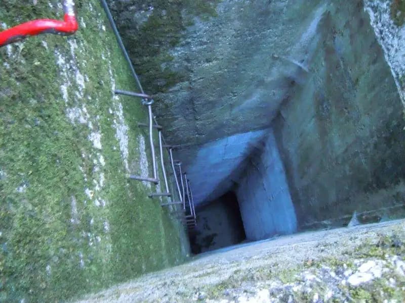
For those seeking a more challenging and complete hike, there is the option to continue beyond the blue marks: proceed along the stream to a Tibetan bridge, then follow an equipped path marked in red that leads back near the railway. Skirting the tracks, you reach an access shaft, from which you descend and continue toward Rocca San Zenone, then climb back up to the car. This longer loop, which fully explores the gorge system, takes about five hours, plus at least an additional hour for the return to the parking area from Rocca San Zenone, for a total of at least six hours.
Track and weather
Plan the route
Preview the GPX track from the backend, download it for your GPS device, open parking directions, and check a short forecast before leaving.
Images
FAQ
What level of commitment does this via ferrata require?
ferrata.faqAnswers.commitment
How much elevation gain should I plan for?
The listed ferrata elevation gain is 40 m. Also consider approach, return and maximum altitude, because they can matter more than the equipped section alone.
Where is the route located?
Ferrata Gole del Serra is located in Appenino Umbro Marchigiano, Terni, Italy. Before leaving, check parking, access and current local conditions.
When is the best time to climb it?
The best season depends on altitude, aspect and lingering snow. Avoid storms, wet rock and uncertain conditions; start early and keep a margin for the return.
Gear and safety planning
Use the technical data on this page to plan equipment, timing and offline navigation. For a general checklist, read the equipment guide before opening the route in the app.
Video
Watch the route
Useful YouTube videos for getting a real feel for the route before you go.
Logbook
Route condition reports
Recent community notes about closures, snow, equipment damage, trail issues and current conditions.
Community
Reviews, check-ins and photos
-
0 reviews
2
2 climbers
0
Shared by the community
Community photos
Recent images uploaded by Sferrati members.
No community photos yet
Open this route in the app to add the first photo.
Reviews
Recent impressions from climbers who know the route.
No reviews yet
Be the first to review this via ferrata from the app.
Continue in the app
Track the climb, save maps offline, and sync this route to your personal profile.
Use the app to climb
Offline maps, tracking, saves, and profile sync.
Scan the code before leaving, install the app, and keep your route data ready when reception fades.
