
Technical data
- Difficulty
- Difficile
- Status
- aperta
- Distance
- 13 km
- Total duration
- 4 h 45 min
- Approach
- 2 h 30 min
- Ferrata time
- 1 h
- Elevation gain
- 936 m
- Max altitude
- 2670 m
Route planning
How to plan Ferrata Kaiserjager al Col Ombert
Ferrata Kaiserjager al Col Ombert is in Col Ombert, Trento, Italy and is rated Difficile. Available route data lists about 4 h 45 min total time, 13 km of distance, 936 m of elevation gain.
For day planning, consider an approach of about 150 min, about 60 min on the cable, a maximum altitude near 2670 m. Reported route features include: Interesse Storico.
The page includes a parking or driving-directions reference. A GPX track is available to review and download.
As with every via ferrata, evaluate season, lingering snow, storms, crowds and equipment condition. Page last updated on 7/4/2026.
Features
Description
Overview
The Ferrata Kajserjager, a historic route culminating on the summit of Col Ombert, offers a rewarding alpine experience set against an exceptionally beautiful landscape. The complete itinerary is quite extensive, while the actual via ferrata section itself is of moderate length. The main approach is from Val San Nicolò in Val di Fassa, though an alternative approach exists from the Val Contrin side.
Approach
The starting point is Baita Ciampiè in Val San Nicolò. From Pozza di Fassa, take the road heading south, ignoring the turnoffs for Val Monzoni, until you reach a large paid parking area. In high season, you must park here; during less busy periods, you can continue by car up to the hut.
From the parking lot, follow the paved road uphill for about twenty minutes to Baita Ciampiè, where Col Ombert already comes into view. Continue along the dirt road, which coincides with trail CAI 608, heading toward Passo San Nicolò. Half an hour from the parking lot, you reach a signed junction at 1960 meters: take the left fork onto a path that climbs at a steady gradient, first reaching Pociace (2260 m, 1 hour total), then Cima Pre de Contrin (2365 m, 1h15'). Here you intersect trail CAI 613; turn right, traversing at mid-height above Val de Contrin, with the Rifugio Passo San Nicolò (2340 m) now in sight. Reaching the refuge in one and a half hours, follow the signs to a Great War cavern, reachable in twenty minutes. Near a commemorative plaque, it's convenient to gear up before the start of the ferrata, which is reached two hours total from the parking lot.
Terrain and pace: The approach unfolds across grassy and scree slopes, characteristic of the eastern Dolomite flanks, with a steady, regular elevation gain. The well-defined trail proceeds at a brisk but not overly steep pace, offering expansive views over the San Nicolò basin. The morphology is typical of a high-altitude environment, with broad screes and outcropping rocks that foreshadow the compact wall ahead.
Via Ferrata
The equipped route begins with a challenging but well-stepped chimney, requiring careful attention to handholds. A short traverse to the left leads to the crux of the route: an overhang that bulges out from the wall, negotiable with climbing technique or a determined pull with the arms.
Continue on a more relaxed section, enjoying the view of Passo San Nicolò, then ascend some slabs following the steel cable. Reaching a spur, stay on the left side, tackling short, climbable sections until a long ramp with no difficulty, marked in its center by an old metal ladder.
Past the ramp, the steepness increases with a zigzag path that gains height up to an exposed ledge, bordered by old equipment. At its end, a vertical, athletic wall awaits; less experienced climbers will need to rely on pulling on the cable. Then comes a third challenging passage with a slight overhang, best overcome on the right side.
You are now in the final section: after a series of easy rocky steps, you emerge onto an unsecured trail that leads in a few minutes to the summit cross of Col Ombert (2670 m). The summit panorama, embracing Cima Uomo, the Marmolada, and Val San Nicolò, rewards the effort. The time on the ferrata is about one hour, for a total of three hours from the parking lot.
Experience and character of the route: The ferrata unfolds on a compact dolomite wall, articulated through chimneys, ledges, and short vertical sections. The pace is discontinuous: technical and physically intense passages (like the initial chimney and the overhang) alternate with calmer ramps and horizontal resting sections. The exposure is marked, especially on the ledge and airy sections, giving the route a predominantly vertical and panoramic character. The presence of historic equipment adds a particular charm, without compromising overall safety.
Descent
From the summit, descend on the opposite side from the ascent, following a steep track that requires caution, especially when wet. Descend a gully with tight switchbacks until you reach trail CAI 609. Here you have two options.
The first option is to keep left and continue descending until you spot a track on the left that skirts the northwest face of Col Ombert. This mid-height scree path leads to CAI 608, from which you regain the lost elevation with a tiring climb back to the Rifugio Passo San Nicolò (2340 m, 1h15' from the summit). From here, retrace the approach trail for a few meters to a wide mule track that descends toward Baita delle Cascate (2011 m, 30' from the refuge). From the hut, follow the dirt road west to the junction encountered on the way up, then descend along the dirt road to the parking lot (30' from the hut). The complete return with this option takes about 2h15' from the summit, for a total of 5h15'.
The second option, from the junction with CAI 609, keeps right toward Pas Paschè. This variant loses less elevation, but a landslide reported in 2017 makes the route more problematic. From Pas Paschè (2500 m), follow CAI 609 in constant descent to Baita delle Cascate (1h15' from the summit), then return to the parking lot as described above, with a total time of about 4h45'.
Terrain and pace of the descent: The descent takes place in a different environment, more scree-filled and unstable, characterized by a gravelly gully and grassy slopes. The pace is inevitably conditioned by the need to control progress on loose ground, with steep sections requiring caution. The first option, though involving an annoying final up-and-down, follows more defined tracks; the Pas Paschè variant, while more direct, has a section made uncertain by the landslide, adding an element of logistical difficulty.
Useful Notes
The Ferrata Kajserjager al Col Ombert is a highly satisfying route, with breathtaking views of the main Dolomite peaks. The via ferrata concentrates its difficulties in three or four passages, requiring good athletic fitness and solid climbing technique, but overall it is pleasant and climbable. The length of the approach and return makes it less crowded than other ferratas in the area, an advantage in a very touristy region.
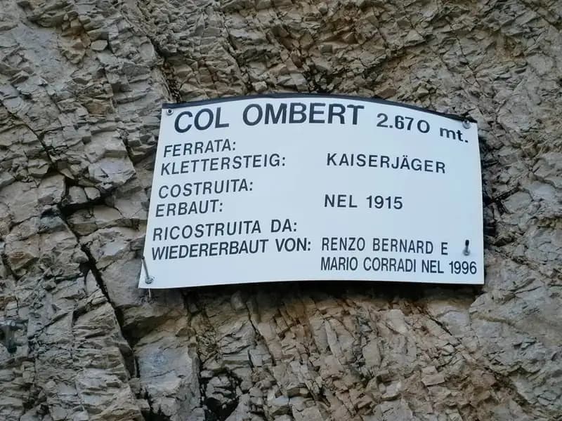
It is essential to pay maximum attention to the ground, which is often loose and rocky, to avoid dislodging and dropping stones on those climbing below. The historic route, originally built in 1915 for military purposes by the Austrian Kaiserjäger and renovated in 1996, still retains some evocative period equipment. The area is rich in other via ferratas, such as the Ferrata dei Magnifici 4 or the Ferrata Ombretta, offering many opportunities for enthusiasts.
Concluding analysis of the experience: The route combines a prolonged hiking approach with a technical but not overly long ferrata, creating a complete and well-graded experience. The character is that of a traditional ascent in a Dolomite setting, where the physical effort of the approach march transforms into technical effort on the rock, rewarded by a commanding panorama. The relative distance from immediate access points guarantees a certain solitude, increasing the sense of adventure.
Track and weather
Plan the route
Preview the GPX track from the backend, download it for your GPS device, open parking directions, and check a short forecast before leaving.
Images
FAQ
What level of commitment does this via ferrata require?
ferrata.faqAnswers.commitment
How much elevation gain should I plan for?
The listed ferrata elevation gain is 936 m. Also consider approach, return and maximum altitude, because they can matter more than the equipped section alone.
Where is the route located?
Ferrata Kaiserjager al Col Ombert is located in Col Ombert, Trento, Italy. Before leaving, check parking, access and current local conditions.
When is the best time to climb it?
The best season depends on altitude, aspect and lingering snow. Avoid storms, wet rock and uncertain conditions; start early and keep a margin for the return.
Gear and safety planning
Use the technical data on this page to plan equipment, timing and offline navigation. For a general checklist, read the equipment guide before opening the route in the app.
Video
Watch the route
Useful YouTube videos for getting a real feel for the route before you go.
Logbook
Route condition reports
Recent community notes about closures, snow, equipment damage, trail issues and current conditions.
Community
Reviews, check-ins and photos
-
0 reviews
0
0 climbers
0
Shared by the community
Community photos
Recent images uploaded by Sferrati members.
No community photos yet
Open this route in the app to add the first photo.
Reviews
Recent impressions from climbers who know the route.
No reviews yet
Be the first to review this via ferrata from the app.
Continue in the app
Track the climb, save maps offline, and sync this route to your personal profile.
Use the app to climb
Offline maps, tracking, saves, and profile sync.
Scan the code before leaving, install the app, and keep your route data ready when reception fades.
