
Technical data
- Difficulty
- Difficile
- Status
- aperta
- Distance
- 16 km
- Total duration
- 7 h 45 min
- Approach
- 30 min
- Ferrata time
- 3 h
- Elevation gain
- 650 m
- Max altitude
- 2973 m
Route planning
How to plan Ferrata delle Mesules
Ferrata delle Mesules is in Piz Selva, Bolzano, Italy and is rated Difficile. Available route data lists about 7 h 45 min total time, 16 km of distance, 650 m of elevation gain.
For day planning, consider an approach of about 30 min, about 180 min on the cable, a maximum altitude near 2973 m. Reported route features include: Caratteristiche Ferrata, Scale, Avvicinamento corto, Itinerario lungo.
The page includes a parking or driving-directions reference. A GPX track is available to review and download.
As with every via ferrata, evaluate season, lingering snow, storms, crowds and equipment condition. Page last updated on 7/4/2026.
Features
Description
Overview
The Ferrata delle Mesules is a sweeping, demanding alpine itinerary that crosses the western flank of the Sella Group to reach the summit of Piz Selva at 2941 meters. Among the most classic and representative routes in the Dolomites, it offers varied technical progression, with several key unprotected passages that require surefootedness and a head for heights. The reward is a 360-degree panorama over the major massifs of Val di Fassa and Val Gardena. The route's length and isolation demand meticulous planning and stable weather conditions.
The itinerary unfolds primarily across a broad, articulated rock face, characterized by a succession of chimneys, cracks, and ledges. The typical dolomitic rock of the group is often polished by erosion, requiring careful attention when seeking holds. The climbing pace is discontinuous: short vertical or diagonal sections alternate with more horizontal stretches and trail segments, all set against a constant and pronounced exposure that defines the entire experience. The route is predominantly vertical and technical, where physical effort is balanced by the need for concentration on the most exposed and least protected passages.
Approach
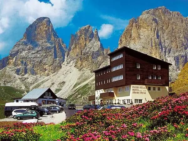
The recommended starting point is Passo Sella, the connecting hub between Val di Fassa and Val Gardena. Park near the Albergo Maria Flora on the Fassa side to facilitate your return. From here, take trail CAI 649, which heads northeast toward the imposing Torri del Sella. The approach begins on a comfortable grassy slope before transitioning into a steep debris-filled gully; with increasing gradient, it leads in about 30 minutes to the official start of the via ferrata, located at 2290 meters.
The initial environment is a broad debris cone at the base of the wall, gradually introducing the severity of the route. The morphology is that of a recessed gully, preparing you for a shift in pace: from trail walking to a steeper, more unstable approach, foreshadowing the technical and physical character of the itinerary itself.
Via Ferrata
The current route presents increased difficulty compared to the historic line. After the first few meters on unroped rock, you climb a leftward-slanting wall, entering the first of a series of chimneys. The initial holds are solid, then some pitons mark sections of more polished rock. Vertical and diagonal stretches alternate along a crack, leading to a small ledge that introduces the most challenging section.
You are faced with a rocky recess to ascend with Class I and II moves. This section is not protected by a steel cable and demands concentration and a stemming movement, using your hands on both sides of the crack to overcome an obstacle and reach some stirrups. Once past this crux, a short descent leads to the first ladder of the route, from which you can look back at the passage just completed.
Shortly after, you tackle the second critical passage: a narrow chimney between two walls, climbed primarily using stirrups (first on the left, then on the right) and also lacking a safety cable. The ascent may require chimneying and stemming against the right wall. The upper part of the chimney narrows considerably; the exit, very exposed, occurs on the left side using two rungs, then you take an unstable metal ladder onto a small ledge.
Exiting the chimney, you continue on a smooth wall before finding more climbable rock. You ascend an easy chimney with excellent natural holds and stirrups, followed by a few short equipped horizontal sections. Once the fixed gear ends, you climb a gully on a faint trail until an exposed traverse at mid-height that, trending right, allows you to gain elevation and reach the vast, barren Altopiano delle Mesules.
A connecting trail leads beneath the final equipped sector. From an exposed ledge, you pick up the cables again to tackle a series of nice rock steps, generally well-holded and only partially equipped. After climbing these non-difficult passages, you reach the upper part of the plateau and, in a few minutes, the summit of Piz Selva (2941 m). The climbing time from the start is about 3 hours, for a total of 3 hours and 30 minutes from the parking lot.
The route's development is predominantly vertical in the first half, with a succession of chimneys and cracks that impose a slow, deliberate pace. The environment is that of a great wall furrowed by fracture lines, where progression becomes intimate and physical, especially in the narrow, unprotected passages. After the strenuous ascent, reaching the Altopiano delle Mesules marks a turning point: the pace becomes more regular and walkable, exposure remains, but the character becomes more panoramic and open, culminating in the final rock steps toward the summit.
Descent
From the summit of Piz Selva, the long return begins. Traverse the Altopiano delle Mesules northeast, following the traces and markers of trail CAI 649 toward Piz Miara (2964 m). From here, you have two options: The normal route continues on the 649, skirting the plateau, ignoring the junctions for Rifugio Pisciadù (CAI 767) and Val de Tita (CAI 666), until reaching Forcella dell'Antersass (2842 m) in about 1 hour and 15 minutes from the summit. Descend right on the steep trail CAI 647 into Val de Lasties, reaching Pian di Sella (2283 m) in another hour and a quarter. From here, following signs and an uphill asphalt road, you return to Passo Sella in about 1 hour and a half. The complete descent takes about 4 hours from the end of the ferrata, for a total hike of 7 hours and 30 minutes. A more direct alternative, reserved for experienced hikers, descends from below Piz Miara via a steep, unmarked gully with faint traces and a couple of short equipped sections. This gully, to be identified carefully, emerges directly into Val de Lasties, saving about an hour and a half and reducing the total hike time to about 6 hours. Once on the valley floor, you join the marked trail for the return to Passo Sella.
The descent represents a substantial part of the overall effort. The pace is that of a long, sometimes monotonous walk in a high-altitude, barren, and wild environment. The Altopiano delle Mesules is a vast karst basin, crisscrossed by trails that snake between hummocks and hollows, where maintaining orientation is crucial. The character of the return is therefore predominantly physical and endurance-based, with reduced exposure but a constant awareness of isolation.
Useful Notes
The Ferrata delle Mesules is a distinctly alpine excursion, reserved for experienced, fit hikers with no fear of heights. The two key unprotected passages in the first section, with a maximum difficulty of Class II, represent a psychological challenge above all, due to the exposure and confined spaces. The chimney in particular requires agility in the final rotation; bulky backpacks are discouraged, and in case of difficulty, a quickdraw can be useful to clip your pack to your harness.
Planning is essential. The Altopiano delle Mesules is a wild, isolated environment with no support points. The risk of losing orientation in fog or sudden bad weather is real. It is therefore imperative to undertake the itinerary only with stable and persistent weather forecasts.
For maps, detailed maps of Val Gardena, Val di Fassa, or Val Badia are recommended. The ferrata, originally called the Possnecker Klettersteig, was established in 1912 by the German and Austrian Alpine Club with the aim of connecting Passo Sella to Rifugio Boè, and its name is linked to the mountaineering and historical diary "I giorni delle Mesules" by Ettore Castiglioni.
Track and weather
Plan the route
Preview the GPX track from the backend, download it for your GPS device, open parking directions, and check a short forecast before leaving.
Images
FAQ
What level of commitment does this via ferrata require?
ferrata.faqAnswers.commitment
How much elevation gain should I plan for?
The listed ferrata elevation gain is 650 m. Also consider approach, return and maximum altitude, because they can matter more than the equipped section alone.
Where is the route located?
Ferrata delle Mesules is located in Piz Selva, Bolzano, Italy. Before leaving, check parking, access and current local conditions.
When is the best time to climb it?
The best season depends on altitude, aspect and lingering snow. Avoid storms, wet rock and uncertain conditions; start early and keep a margin for the return.
Gear and safety planning
Use the technical data on this page to plan equipment, timing and offline navigation. For a general checklist, read the equipment guide before opening the route in the app.
Video
Watch the route
Useful YouTube videos for getting a real feel for the route before you go.
Logbook
Route condition reports
Recent community notes about closures, snow, equipment damage, trail issues and current conditions.
Community
Reviews, check-ins and photos
-
0 reviews
2
2 climbers
0
Shared by the community
Community photos
Recent images uploaded by Sferrati members.
No community photos yet
Open this route in the app to add the first photo.
Reviews
Recent impressions from climbers who know the route.
No reviews yet
Be the first to review this via ferrata from the app.
Continue in the app
Track the climb, save maps offline, and sync this route to your personal profile.
Use the app to climb
Offline maps, tracking, saves, and profile sync.
Scan the code before leaving, install the app, and keep your route data ready when reception fades.
