
Technical data
- Difficulty
- Difficile
- Status
- aperta
- Distance
- 1,5 km
- Total duration
- 2 h 45 min
- Approach
- 15 min
- Ferrata time
- 2 h
- Elevation gain
- 225 m
- Max altitude
- 1358 m
Route planning
How to plan Ferrata Olberg
Ferrata Olberg is in Alpi Noriche, Bolzano, Italy and is rated Difficile. Available route data lists about 2 h 45 min total time, 1,5 km of distance, 225 m of elevation gain.
For day planning, consider an approach of about 15 min, about 120 min on the cable, a maximum altitude near 1358 m. Reported route features include: Avvicinamento corto, Ponti sospesi, Scale.
The page includes a parking or driving-directions reference. A GPX track is available to review and download.
As with every via ferrata, evaluate season, lingering snow, storms, crowds and equipment condition. Page last updated on 7/4/2026.
Features
Description
Overview
The Val di Vizze, near Vipiteno, inaugurated its first via ferrata in 2022: the Ferrata Olberg. This modern route, taking about two hours, unfolds on a compact wall of dark dolomite, characterized by an architecture articulated across ledges and short overhangs. The overall commitment is classifiable as moderate, with a progression that alternates fluid sections with more sustained passages, also offering two optional variants of higher difficulty that increase its technical character.
Approach
Access is from the road that leads from Vipiteno toward San Jakob in the Val di Vizze. After passing the locality of Prati and traveling about five minutes along the main road, you go through a tunnel. Exiting the tunnel, after two hundred meters on the left, you take a descending dirt road that leads to the parking area. From here, the approach to the start is short: proceed south along the old carriage road until you reach a rockfall net, in whose immediate vicinity lies the start of the fixed equipment (about 10 minutes from the parking). The setting is immediately alpine, with the wall standing sharply above the wooded valley floor.
Via Ferrata
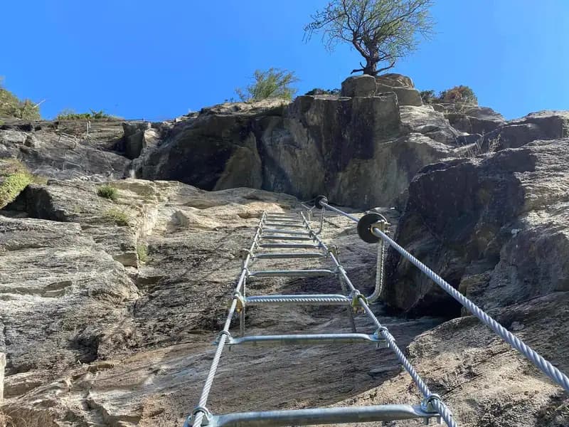
The route begins progressively, with a first small, slabby wall that introduces you to the rock. A short trail section leads to a second easy wall, which veers left to a metal ladder. After climbing it, an un-equipped path allows you to comfortably reach the base of the main wall, where the ferrata takes on its distinctive character.
The ascent continues by tackling a succession of small walls, following the line of least resistance offered by the rock structure. The insertion of a second ladder signals an increase in steepness, a prelude to a more demanding section. Continuing left, after a third ladder, you overcome a vertical bulge: this passage requires greater physical effort but offers good holds, while the exposure begins to become significant. You then reach an exposed traverse to the right, followed by a small wall and a long ladder. A further horizontal traverse to the left precedes another short wall and a fourth ladder.
At this point, about halfway through the route (about 40 minutes from the start, for a total activity time of one hour), you encounter an escape route to the left. It is good to know that the second part of the Ferrata Olberg presents increasing difficulty, while still remaining within the "moderately difficult" range, except for the two optional variants classified as "difficult." The pace becomes more broken, with a succession of choices that modulate the effort.
Continuing, you face a first choice: to the left the moderate option, to the right the difficult one. The challenging variant involves a traverse followed by an athletic passage on a small wall with more demanding holds. After overcoming this section, you exit the wall and arrive at a junction for the "Nicchia dei Camosci," a panoramic point on the right; going left rejoins the main route.
Shortly after, a new ladder presents a second junction. To the right, the moderate variant develops, with a short vertical wall whose difficulties are concentrated in the first few meters. To the left, instead, begins the second difficult variant, characterized by a demanding traverse with a slight overhang and a subsequent rather athletic vertical section, requiring good arm strength and control of your center of gravity.
An equipped transfer section to the right leads to the third and final junction. Here, to the right, an easy variant with modest difficulties leads directly toward the woods, while to the left a new difficult variant climbs vertically with a slight overhang, requiring sustained technical effort. This last one converges, after a final long ladder, with the main route.
The finale of the Ferrata Olberg presents no further significant obstacles: you continue to the right, alternating short rock steps and horizontal sections until the end of the fixed equipment (about 2 hours from the start). The last section is panoramic and relaxing, with the valley progressively opening up to view.
Immediately after the end of the ferrata, without removing your harness, you can follow the descent trail that quickly leads to a marked junction for an optional suspended Tibetan bridge. The bridge, stable and about twenty meters long, is crossed, after which you continue to the right on a traverse and then descend to the end of all the equipment (about 2 hours and 30 minutes total). This airy appendix offers a further perspective on the rocky canyon.
Descent
From the end of the equipment, descend along the trail until you intercept the approach path. Turning right, you quickly return to the parking area, for a total travel time of about 2 hours and 45 minutes. The descent is quick and comfortable, immersed in the coniferous forest.
Useful Notes
This via ferrata, inaugurated in 2022, boasts equipment in excellent condition and offers beautiful views of the Val di Vizze below. Thanks to its altitude and sunny exposure, it is a route that can also be done during the shoulder seasons, when higher walls are already snow-covered. It represents an excellent choice for those seeking a modern, safe, and well-structured experience in a highly fascinating alpine context, with a good balance between physical effort, technique, and enjoyment of the environment.
Track and weather
Plan the route
Preview the GPX track from the backend, download it for your GPS device, open parking directions, and check a short forecast before leaving.
Images
FAQ
What level of commitment does this via ferrata require?
ferrata.faqAnswers.commitment
How much elevation gain should I plan for?
The listed ferrata elevation gain is 225 m. Also consider approach, return and maximum altitude, because they can matter more than the equipped section alone.
Where is the route located?
Ferrata Olberg is located in Alpi Noriche, Bolzano, Italy. Before leaving, check parking, access and current local conditions.
When is the best time to climb it?
The best season depends on altitude, aspect and lingering snow. Avoid storms, wet rock and uncertain conditions; start early and keep a margin for the return.
Gear and safety planning
Use the technical data on this page to plan equipment, timing and offline navigation. For a general checklist, read the equipment guide before opening the route in the app.
Video
Watch the route
Useful YouTube videos for getting a real feel for the route before you go.
Logbook
Route condition reports
Recent community notes about closures, snow, equipment damage, trail issues and current conditions.
Community
Reviews, check-ins and photos
-
0 reviews
0
0 climbers
0
Shared by the community
Community photos
Recent images uploaded by Sferrati members.
No community photos yet
Open this route in the app to add the first photo.
Reviews
Recent impressions from climbers who know the route.
No reviews yet
Be the first to review this via ferrata from the app.
Continue in the app
Track the climb, save maps offline, and sync this route to your personal profile.
Use the app to climb
Offline maps, tracking, saves, and profile sync.
Scan the code before leaving, install the app, and keep your route data ready when reception fades.
