
Ferrata Maximilian ai Denti di Terrarossa
Denti di Terrarossa · Bolzano · Italy
Technical data
- Difficulty
- Difficile
- Status
- aperta
- Distance
- 20,2 km
- Total duration
- 9 h 15 min
- Approach
- 4 h 30 min
- Ferrata time
- 2 h 30 min
- Elevation gain
- 214 m
- Max altitude
- 2655 m
Route planning
How to plan Ferrata Maximilian ai Denti di Terrarossa
Ferrata Maximilian ai Denti di Terrarossa is in Denti di Terrarossa, Bolzano, Italy and is rated Difficile. Available route data lists about 9 h 15 min total time, 20,2 km of distance, 214 m of elevation gain.
For day planning, consider an approach of about 270 min, about 150 min on the cable, a maximum altitude near 2655 m. Reported route features include: Itinerario lungo, Itinerario Alpinistico.
The page includes a parking or driving-directions reference. A GPX track is available to review and download.
As with every via ferrata, evaluate season, lingering snow, storms, crowds and equipment condition. Page last updated on 7/4/2026.
Features
Description
Overview
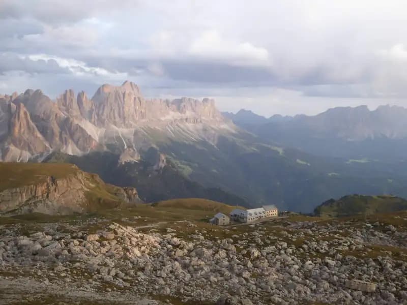
The Ferrata Maximilian traces a bold line along the severe rocky crest that separates Cima di Terrarossa from the Denti di Terrarossa, towering over the Alpe di Tires in the province of Bolzano. This route sits in a border zone between mountaineering and via ferrata: its nature is decidedly mixed, more akin to an alpine climb than a conventional protected vertical route. The short sections of cable and steps present modest technical difficulty, but the exposure is constant and pronounced. The route is interspersed with numerous free climbing passages, of grade I and occasionally II, demanding surefootedness and excellent balance control. The morphology of the ridge-at times knife-edged, at others articulated on ledges-defines a continuous and challenging character. The reward for the effort invested is an exceptional 360-degree panorama over the Rosengarten Group and the Dolomite horizon.
Approach
The logical starting point is the village of Lavinia Bianca, reachable from Bolzano via Prato Isarco and the turnoff for Tires. Free parking is available near the Visitor Center of the Nature Park. An alternative, using the cable car, starts from Siusi to ascend to Campaccio and then head toward the Passo dell'Alpe di Tires. It is essential to emphasize that the Ferrata Maximilian can be traversed in either direction. The following description adopts the direction from Rifugio Bolzano toward Rifugio Tires, generally considered slightly less demanding as it tackles the steepest sections in descent. From the parking lot (1200 m), take the steep trail 2 that enters the forest. After a tight series of switchbacks, ascend the Canalone Barengalle, characterized by a long succession of wooden walkways, until gaining the Sella Cavaccio. From here, to reach Rifugio Bolzano (2450 m), you can continue keeping trail 2 on the right, or proceed straight on trails 9 and then 1. From the refuge, join trail 4, which crosses the Scillar plateau, ignoring the turnoff for trail 1. At the next junction, leave trail 4 to take trail 4B on the left, which leads to the actual start of the route (2560 m). The approach from the parking lot requires about 4 hours and 30 minutes of sustained hiking.
Via Ferrata
From the junction, a steep trail marked by cairns gains about 100 meters of elevation to the summit of Cima di Terrarossa (2655 m), marked by a cross. From here, descend along an easy ridge section, with Rifugio Tires already coming into view. After about 10 minutes of walking on an airy but non-technical trail, a faded metal plaque indicates the start of the first equipped section: this is a steep and exposed descent, technically simple but already significant for its exposure. Immediately after, you encounter the first challenging free climbing passage, where you bypass a sharp ridge section by descending on the right (south) side. This is followed by other short free descent passages before an equipped diagonal ramp that offers a moment of greater security. You reach a dirt saddle where, about 40 minutes from the summit, an escape route is indicated on the right, descending toward the trail 4 below. The route continues on small slabs and unstable rocks on the right side of the ridge, then ascends a vertical section well-equipped with cables and steps. You then traverse a particularly exposed ridge section on both sides, offering a fine backward view of Cima di Terrarossa. Next comes the ascent of a narrow chimney, easier to climb up than down, using natural holds and a short cable on the right. Exiting the chimney, follow an airy ridge section with continuous ups and downs to a new saddle, a true panoramic balcony overlooking the ridge just traversed and the refuge below. You then climb a beautiful equipped vertical wall, decidedly climbable, to reach one of the iconic points: a natural rock arch, to be crossed carefully due to the loose, unstable ground. A comfortable ridge trail gradually narrows, becoming rocky and sharp again, then descends with the aid of metal fixtures over some steps. From a notch, descend to the right into a steep, debris-filled gully exposed to the south. This long section alternates short equipped parts with unprotected stretches, with the main difficulty being the instability of the gravelly ground and the constant steepness. After bypassing some boulders, a final equipped section skirts a wall on the right. After the last unprotected rocks, the descent concludes by reaching Rifugio Alpe di Tires (2440 m). The rhythm of the route is discontinuous, with phases of concentrated climbing alternating with challenging hiking on debris. The time for the via ferrata is about 2 hours and 30 minutes from the 4B junction, for a total of about 7 hours from the parking lot.
Descent
For the most direct return to Lavinia Bianca, from Rifugio Tires take trail 3 heading west. Follow a section parallel to the ridge of the via ferrata to a junction: continuing straight would lead back to Rifugio Bolzano, while keeping left descends via the steep and partially equipped "Buco dell'Orso". Always staying on trail 3 and ignoring the 3A and 3B turnoffs, descend along the splendid Valle del Ciamin to Lavinia Bianca, remaining on trail 3 and ignoring the junction for trail 13. The descent to the parking lot requires about 2 hours and 15 minutes of walking, for a total hike of about 9 hours and 15 minutes.
Useful Notes
The Ferrata Maximilian is often subject to inaccurate assessments. The equipped sections are in excellent condition and of low-to-medium technical difficulty, but the route unfolds in a highly exposed and articulated context, with numerous free climbing passages (grade I and II) that unequivocally define its alpine character. The presence of an escape route halfway should be considered carefully: once past certain key points, retreat can prove more complicated than continuing. From an alpine perspective, the overall difficulty is considered moderate-easy, but the commitment is primarily physical and mental, given the length and isolation of the route. Given the total length and elevation gain, you might consider splitting the excursion over two days, staying overnight at altitude and combining other via ferratas in the Rosengarten Group, such as the Laurenzi or the Ferrata al Catinaccio d'Antermoia. For maps, the 4Land maps of the Val di Fassa or of Sciliar, Catinaccio and Latemar are recommended. The via ferrata takes its name from its builder, Maximilian Aichner, the historic manager of Rifugio Alpe di Tires, and was completed in 1969.
Track and weather
Plan the route
Preview the GPX track from the backend, download it for your GPS device, open parking directions, and check a short forecast before leaving.
Images
FAQ
What level of commitment does this via ferrata require?
ferrata.faqAnswers.commitment
How much elevation gain should I plan for?
The listed ferrata elevation gain is 214 m. Also consider approach, return and maximum altitude, because they can matter more than the equipped section alone.
Where is the route located?
Ferrata Maximilian ai Denti di Terrarossa is located in Denti di Terrarossa, Bolzano, Italy. Before leaving, check parking, access and current local conditions.
When is the best time to climb it?
The best season depends on altitude, aspect and lingering snow. Avoid storms, wet rock and uncertain conditions; start early and keep a margin for the return.
Gear and safety planning
Use the technical data on this page to plan equipment, timing and offline navigation. For a general checklist, read the equipment guide before opening the route in the app.
Video
Watch the route
Useful YouTube videos for getting a real feel for the route before you go.
Logbook
Route condition reports
Recent community notes about closures, snow, equipment damage, trail issues and current conditions.
Community
Reviews, check-ins and photos
-
0 reviews
0
0 climbers
0
Shared by the community
Community photos
Recent images uploaded by Sferrati members.
No community photos yet
Open this route in the app to add the first photo.
Reviews
Recent impressions from climbers who know the route.
No reviews yet
Be the first to review this via ferrata from the app.
Continue in the app
Track the climb, save maps offline, and sync this route to your personal profile.
Use the app to climb
Offline maps, tracking, saves, and profile sync.
Scan the code before leaving, install the app, and keep your route data ready when reception fades.
