
Ferrata Passo dei 6 Monte Coppolo
Monte Coppolo · Belluno · Italy
Technical data
- Difficulty
- Moderatamente Difficile
- Status
- aperta
- Distance
- 5 km
- Total duration
- 5 h
- Approach
- 1 h 30 min
- Ferrata time
- 1 h 30 min
- Elevation gain
- 200 m
- Max altitude
- 2069 m
Route planning
How to plan Ferrata Passo dei 6 Monte Coppolo
Ferrata Passo dei 6 Monte Coppolo is in Monte Coppolo, Belluno, Italy and is rated Moderatamente Difficile. Available route data lists about 5 h total time, 5 km of distance, 200 m of elevation gain.
For day planning, consider an approach of about 90 min, about 90 min on the cable, a maximum altitude near 2069 m.
The page includes a parking or driving-directions reference. A GPX track is available to review and download.
As with every via ferrata, evaluate season, lingering snow, storms, crowds and equipment condition. Page last updated on 7/4/2026.
Description
Overview
The Ferrata del Monte Coppolo, in the heart of the Dolomiti Feltrine, is a historic route that underwent a complete modernization and expansion completed in 2022. The route starts from Passo dei 6, follows a ridge, and culminates with the ascent of a final tower. Classified as medium difficulty, it features some more technical passages and a notable exposure that defines its character. The itinerary alternates vertical sections with more horizontal stretches, offering varied progression and constant panoramic views.
Approach
The starting point is the locality of Le Ej, in the province of Belluno. From Lamon, take the small road to the left of the Town Hall, passing under the old hospital and following the signs for Le Ej. After about 9 kilometers, park near the Hotel el Tajol or the Chalet da Pina. An information board illustrates the hiking loop that includes the via ferrata. Follow the well-marked CAI trail, which climbs at a steady gradient. Shortly after, keep left on a marked track, guided by cairns and trail markers, until you reach an important junction. The left branch is the return route (or normal route to Monte Coppolo), while for the start of the via ferrata, continue to the right. The trail becomes steeper, foreshadowing the development of the first equipped section. The approach time from the parking lot is approximately 1 hour and 30 minutes.
Via Ferrata
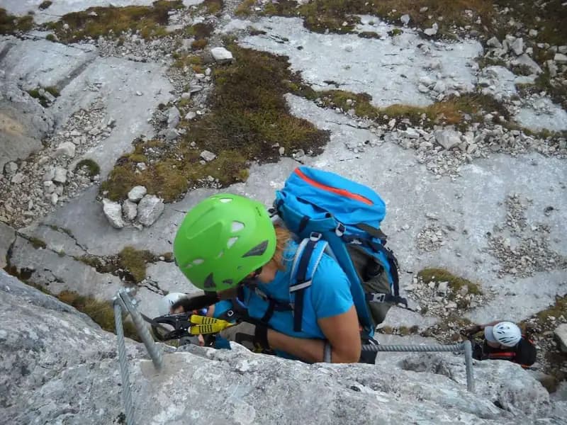
The first segment, called the "Pilastro dei sei", begins near Passo dei 6. An initial diagonal traverse, without difficulty, leads to the base of the vertical structure. The climb develops to the right on a limestone wall, heading toward an inner gully, then tackles a progression vertically with moderate difficulty. The presence of metal rungs aids progression, while the exposure gradually increases, giving a sense of emptiness on the side. After the vertical climb, a final traverse to the right concludes this first section, offering a beautiful panorama of the Dolomiti Feltrine. Once the fixed cables end, continue on an ascending trail to a cross with the summit register. From here begins the second section of the via ferrata, easy and similar to a protected trail, which initially descends along the ridge. You reach a junction and, keeping left as indicated by a sign, arrive at the start of the third and final segment. This final section, the "Pilastro della mezzaluna", while not long, presents greater technical commitment and exposure. After an easy traverse to the right, the route steepens decisively vertically with some difficult passages on compact rock. Once the ridge is reached, a short exposed trail leads to the prominent pillar. You then move to the north side to tackle a decided and challenging vertical climb up a small wall, before the difficulties ease with a traverse to the left and the final stepped moves. The via ferrata ends at the second cross on the west summit. The time to complete the via ferrata from the start is approximately 1 hour and 30 minutes, for a total of about 3 hours from the parking lot.
Descent
From the west summit, locate a not particularly marked track that leads back to the junction between the second and third sections of the via ferrata. From here, continue descending and then rejoin the approach trail, which you retrace back to the parking lot. The total time for the excursion is about 5 hours.
Useful Notes
The Ferrata del Monte Coppolo was completely renovated and reopened to the public in 2022 after a long period of closure. The original route, inaugurated in 1971, ascended from Passo dei 6. The recent work added two new sections, making this beautiful excursion even more interesting and complete. The area of the Dolomiti Feltrine is not rich in via ferratas; for other equipped routes, you must move to the nearby Dolomiti Bellunesi, where options abound.
Track and weather
Plan the route
Preview the GPX track from the backend, download it for your GPS device, open parking directions, and check a short forecast before leaving.
Images
FAQ
What level of commitment does this via ferrata require?
ferrata.faqAnswers.commitment
How much elevation gain should I plan for?
The listed ferrata elevation gain is 200 m. Also consider approach, return and maximum altitude, because they can matter more than the equipped section alone.
Where is the route located?
Ferrata Passo dei 6 Monte Coppolo is located in Monte Coppolo, Belluno, Italy. Before leaving, check parking, access and current local conditions.
When is the best time to climb it?
The best season depends on altitude, aspect and lingering snow. Avoid storms, wet rock and uncertain conditions; start early and keep a margin for the return.
Gear and safety planning
Use the technical data on this page to plan equipment, timing and offline navigation. For a general checklist, read the equipment guide before opening the route in the app.
Video
Watch the route
Useful YouTube videos for getting a real feel for the route before you go.
Logbook
Route condition reports
Recent community notes about closures, snow, equipment damage, trail issues and current conditions.
Community
Reviews, check-ins and photos
-
0 reviews
1
1 climbers
0
Shared by the community
Community photos
Recent images uploaded by Sferrati members.
No community photos yet
Open this route in the app to add the first photo.
Reviews
Recent impressions from climbers who know the route.
No reviews yet
Be the first to review this via ferrata from the app.
Continue in the app
Track the climb, save maps offline, and sync this route to your personal profile.
Use the app to climb
Offline maps, tracking, saves, and profile sync.
Scan the code before leaving, install the app, and keep your route data ready when reception fades.
