
Sentiero Attrezzato del Cacciatore
Sass Maor · Trento · Italy
Technical data
- Difficulty
- Moderatamente Difficile
- Status
- aperta
- Distance
- 14,2 km
- Total duration
- 8 h 30 min
- Approach
- 2 h
- Ferrata time
- 3 h
- Elevation gain
- 650 m
- Max altitude
- 2550 m
Route planning
How to plan Sentiero Attrezzato del Cacciatore
Sentiero Attrezzato del Cacciatore is in Sass Maor, Trento, Italy and is rated Moderatamente Difficile. Available route data lists about 8 h 30 min total time, 14,2 km of distance, 650 m of elevation gain.
For day planning, consider an approach of about 120 min, about 180 min on the cable, a maximum altitude near 2550 m. Reported route features include: Itinerario lungo.
The page includes a parking or driving-directions reference. A GPX track is available to review and download.
As with every via ferrata, evaluate season, lingering snow, storms, crowds and equipment condition. Page last updated on 7/4/2026.
Features
Description
Overview
The Sentiero Attrezzato del Cacciatore is a historic route that climbs the eastern wall of Sass Maor, in the central sector of the Pale di San Martino. This is a demanding itinerary with significant elevation gain, whose technical difficulty has been greatly reduced by recent safety upgrades. The route develops mainly along ledges and gullies, offering continuous, physically challenging progression rather than technical complexity.
Approach
Access begins from Prati Fosne, in Val Canali. From Fiera di Primiero (TN), take SS 347 toward Agordo for about 5 km to the hairpin turn with the sign for Val Canali. Drive up the valley, pass the Hotel Casera, keep right, and continue to the parking area. From here, follow trail marker 719 northeast, initially through dense conifer forest. Once out of the woods, the trail continues on a gentle incline as it climbs the broad, sunlit Val Pradidali to the junction at Pedemonte (about 1 hour 30 minutes). Leave the path to Rifugio Pradidali and turn left onto trail marker 742, which climbs steeply over gravel and scree beneath the colossal eastern walls of Sass Maor. The start of the via ferrata is clearly visible near a prominent debris cone (2 hours total from the parking area). This gradual approach allows you to appreciate the changing landscape, from the wooded valley to the severe Dolomite architecture.
Via Ferrata
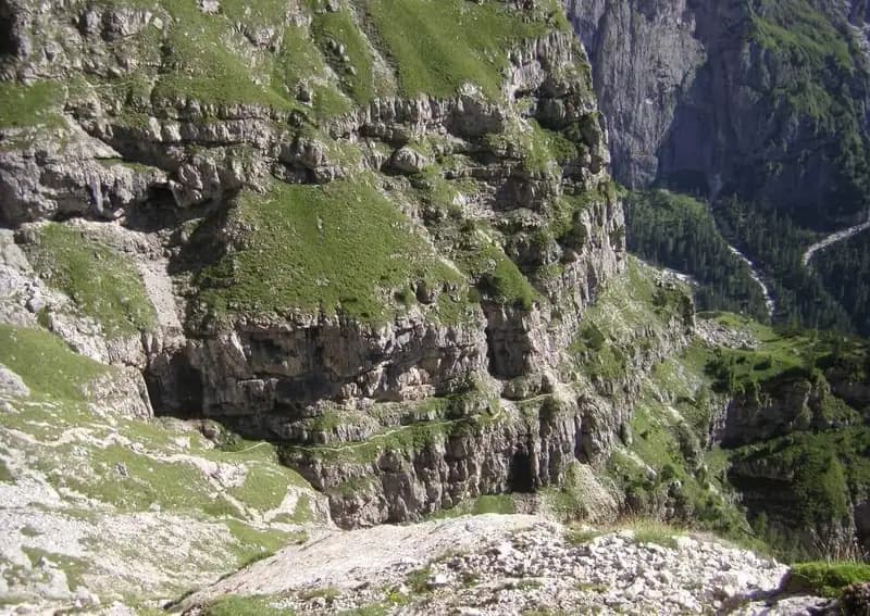
The route begins by climbing the unstable scree zone with the aid of the fixed cables, rejoining the original line. It rounds a rocky spur and ascends leftward along a partially exposed ledge that runs beneath the overhanging walls of Sass Maor. The path alternates at a pleasant rhythm between horizontal sections on protected ledges and short climbs up very climbable rock, with metal stirrups placed at the steeper points. These new fixtures have greatly reduced the difficulties of the historic route, transforming it into a via ferrata of moderate commitment. You then continue along a long, grassy, exposed ledge, round a buttress, and enter the valley that separates Cimerlo from Sass Maor -- a wide, sunlit gully. After a stretch over unstable ground, you reach the passage that was once the crux of the route: a challenging dihedral, now completely overcome by a long series of metal rungs that have eliminated its original difficulty. Exiting this passage, you cross a mixed valley of scree and grass, following the trail markers, until the strenuous but not difficult final climb leads to the col at 2410 meters (2 hours 30 minutes from the start), the end of the Sentiero Attrezzato del Cacciatore. The route is characterized by a sustained, steady pace, with medium-to-high exposure but always well protected, offering grand views over Val Pradidali.
Descent
From the col, two options diverge. To the left, trail marker 747 leads along a ridge and via some equipped sections to the eastern shoulder of Cimerlo (1 hour from the junction), with the possibility of continuing to the summit. This description covers the right-hand option: follow trail marker 742, climbing to Passo della Stanga (2530 m) and then descending to Rifugio Velo della Madonna (2358 m), reachable in about 30 minutes from the junction (5 hours total). From the rifugio, take the Sentiero Attrezzato Depaoli (trail marker 734). This path, which skirts the western walls of Stanga and Cimerlo, features a few easy equipped sections, including a short equipped gully, some ledges, and an easy chimney, before the cables end. It then continues with a long traverse at mid-height, gradually losing elevation with open views over Val Canali, until it returns to Fosne in about 3 hours from the rifugio, for a total of approximately 8 hours 30 minutes from the start of the hike. The descent is therefore long but technically simple, with a more relaxed, contemplative pace.
Useful Notes
This itinerary is very long and demanding in terms of elevation gain, requiring excellent endurance. The technical difficulties are generally low, demanding mainly caution on the many un-cabled sections, where the ground can be uneven or grassy. The originally most challenging passage is now greatly facilitated. Greater difficulties would only be encountered on the optional ascent and descent variant to Cimerlo, which adds alpine commitment. A classic combination is to pair this with the nearby Ferrata Buzzati for the ascent, using the Sentiero del Cacciatore for the descent, creating a highly rewarding loop. For navigation, a detailed map of the Parco Naturale Paneveggio e Pale di San Martino is recommended. This itinerary offers a panoramic and physically complete experience, traversing some of the most spectacular Dolomite environments.
Track and weather
Plan the route
Preview the GPX track from the backend, download it for your GPS device, open parking directions, and check a short forecast before leaving.
Images
FAQ
What level of commitment does this via ferrata require?
ferrata.faqAnswers.commitment
How much elevation gain should I plan for?
The listed ferrata elevation gain is 650 m. Also consider approach, return and maximum altitude, because they can matter more than the equipped section alone.
Where is the route located?
Sentiero Attrezzato del Cacciatore is located in Sass Maor, Trento, Italy. Before leaving, check parking, access and current local conditions.
When is the best time to climb it?
The best season depends on altitude, aspect and lingering snow. Avoid storms, wet rock and uncertain conditions; start early and keep a margin for the return.
Gear and safety planning
Use the technical data on this page to plan equipment, timing and offline navigation. For a general checklist, read the equipment guide before opening the route in the app.
Video
Watch the route
Useful YouTube videos for getting a real feel for the route before you go.
Logbook
Route condition reports
Recent community notes about closures, snow, equipment damage, trail issues and current conditions.
Community
Reviews, check-ins and photos
-
0 reviews
0
0 climbers
0
Shared by the community
Community photos
Recent images uploaded by Sferrati members.
No community photos yet
Open this route in the app to add the first photo.
Reviews
Recent impressions from climbers who know the route.
No reviews yet
Be the first to review this via ferrata from the app.
Continue in the app
Track the climb, save maps offline, and sync this route to your personal profile.
Use the app to climb
Offline maps, tracking, saves, and profile sync.
Scan the code before leaving, install the app, and keep your route data ready when reception fades.
