
Sentiero Attrezzato Gusella
Dolomiti delle Pale di San Martino · Trento · Italy
Technical data
- Difficulty
- Moderatamente Difficile
- Status
- aperta
- Distance
- 18 km
- Total duration
- 9 h
- Approach
- 2 h 30 min
- Ferrata time
- 2 h 15 min
- Elevation gain
- 262 m
- Max altitude
- 2698 m
Route planning
How to plan Sentiero Attrezzato Gusella
Sentiero Attrezzato Gusella is in Dolomiti delle Pale di San Martino, Trento, Italy and is rated Moderatamente Difficile. Available route data lists about 9 h total time, 18 km of distance, 262 m of elevation gain.
For day planning, consider an approach of about 150 min, about 135 min on the cable, a maximum altitude near 2698 m. Reported route features include: Itinerario lungo.
The page includes a parking or driving-directions reference. A GPX track is available to review and download.
As with every via ferrata, evaluate season, lingering snow, storms, crowds and equipment condition. Page last updated on 7/4/2026.
Features
Description
Overview
The Sentiero Attrezzato Nico Gusella is a long, physically demanding alpine route that winds through the heart of the Dolomiti di San Martino, linking Passo di Ball, Forcella Stephen, and Forcella del Porton. The itinerary stands out for its morphological variety and significant cumulative elevation gain, and should only be tackled in favorable weather with excellent visibility, given the scale and complexity of the terrain.
Approach
The recommended starting point is Malga Civertaghe (1375 m), in the municipality of San Martino di Castrozza (TN), reachable via a forest road of about 3 km. From San Martino, take the state road heading south; just after the fourth hairpin turn, you'll find a road that continues straight ahead. Follow it, keeping right at subsequent junctions, until you reach the parking area. The itinerary described here follows the Sentiero Attrezzato Gusella clockwise, initially ascending toward the Porton. This choice is dictated by the greater ease of identifying the route that skirts Cima di Ball on the ascent. From Malga Civertaghe, take trail 713, which climbs at a steady gradient through sparse woodland, passing the ruins of Malga Sopra Ronz. Emerging from the forest, the trail opens onto a scree slope and reaches a junction: leave trail 713 and turn left onto the track of trail 739. This quickly leads to the first equipped section, the Ferrata della Vecia. This short route, recently renovated, uses metal fixtures and rungs to overcome a compact wall of about 50 meters. Once past it, continue on trail 739 across a grassy slope that soon turns rocky, climbing steeply and continuously until you reach the distinctive Forcella del Porton (2460 m). The walking time is about 2 hours and 30 minutes from the parking area. Just before the notch, a signpost on the left indicates trail 714 toward Passo di Ball, marking the start of the Sentiero Attrezzato Gusella.
Via Ferrata
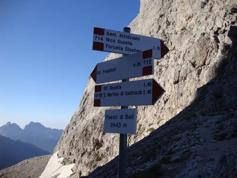
From Forcella del Porton, the route skirts the southern face of Cima di Ball along a trail that gradually ascends toward Forcella della Fede. The environment is severe, characterized by gray dolomite rock and grassy ledges. From here, following red paint marks, descend carefully along an unprotected gully-a section that demands balance and control. At the end of the gully, the trail bends right, and the first fixed cables begin. The route unfolds as a long diagonal traverse across the western wall of Cima Ball, a succession of equipped sections and passages on bare, unprotected rock that require steady footing and constant concentration. Although the itinerary lacks any single extreme move, it takes place in a completely rocky and at times exposed environment, with a sustained pace and few spots for relaxed breaks. The visual target is a notch in the rock, reached after a lengthy diagonal traverse, finally arriving at Forcella Stephen (2650 m), a panoramic watershed point, in about 1 hour and 30 minutes from the Porton (4 hours total). From Forcella Stephen, descend toward Passo di Ball. The descent begins on a steep, gravelly track, then meets the cables that allow you to tackle vertical sections and smooth slabs. The character of this stretch is markedly more vertical and technical than the previous traverse. The route descends diagonally, crosses a slab leaning at about 20 meters, continues diagonally again, and tackles a short chimney. The cable continues in vertical descent, alternating with brief ledges and rock steps, until the equipped section ends. From here, on a simple trail, you reach Passo di Ball (2443 m) in about 45 minutes from Forcella Stephen (4 hours and 45 minutes total).
Descent
From Passo di Ball, for the return to Malga Civertaghe, take the descending trail 715 to the right, which in about 20 minutes leads to Rifugio Pradidali (2278 m). From the refuge, following the signs to the right, descend for about 40 minutes to the start of the Ferrata del Porton. Then ascend this challenging but not difficult exposed route, which in about 1 hour and 30 minutes brings you back to Forcella del Porton (for a total of about 2 hours and 30 minutes from Passo di Ball, 7 hours and 15 minutes total). From here, to close the loop, descend again via the approach trail toward Malga Civertaghe in about 1 hour and 45 minutes (9 hours total). A longer alternative involves heading from the notch toward Rifugio Velo della Madonna by descending the Ferrata del Velo (about 10 hours and 30 minutes total).
Useful Notes
The Sentiero Attrezzato Gusella is a long, physically draining, and technically varied itinerary. It is essential to consider that the total elevation gain also includes the descent from Forcella Stephen to the base of the Ferrata del Porton. To fully enjoy it, it is ideal to split it over two days, staying overnight at Rifugio Pradidali and incorporating both the Ferrata del Porton and the Ferrata del Velo into the return. Maximum caution is required on the numerous unprotected sections between Forcella del Porton and Forcella Stephen, especially on wet or icy rock, where progression is slow and deliberate. The descent from Forcella Stephen to Passo di Ball, though an equipped trail, features verticality and technical commitment comparable to a true via ferrata-never extremely difficult but never trivial either, requiring continuous use of the gear. The panoramas on both sides of the Pale di San Martino are magnificent and expansive, rewarding the effort. For experienced hikers, an unequipped trail from Forcella Stephen leads to the summit of Cima Ball. It is recommended to use the official map of the Parco Naturale Paneveggio Pale di San Martino.
Track and weather
Plan the route
Preview the GPX track from the backend, download it for your GPS device, open parking directions, and check a short forecast before leaving.
Images
FAQ
What level of commitment does this via ferrata require?
ferrata.faqAnswers.commitment
How much elevation gain should I plan for?
The listed ferrata elevation gain is 262 m. Also consider approach, return and maximum altitude, because they can matter more than the equipped section alone.
Where is the route located?
Sentiero Attrezzato Gusella is located in Dolomiti delle Pale di San Martino, Trento, Italy. Before leaving, check parking, access and current local conditions.
When is the best time to climb it?
The best season depends on altitude, aspect and lingering snow. Avoid storms, wet rock and uncertain conditions; start early and keep a margin for the return.
Gear and safety planning
Use the technical data on this page to plan equipment, timing and offline navigation. For a general checklist, read the equipment guide before opening the route in the app.
Video
Watch the route
Useful YouTube videos for getting a real feel for the route before you go.
Logbook
Route condition reports
Recent community notes about closures, snow, equipment damage, trail issues and current conditions.
Community
Reviews, check-ins and photos
-
0 reviews
0
0 climbers
0
Shared by the community
Community photos
Recent images uploaded by Sferrati members.
No community photos yet
Open this route in the app to add the first photo.
Reviews
Recent impressions from climbers who know the route.
No reviews yet
Be the first to review this via ferrata from the app.
Continue in the app
Track the climb, save maps offline, and sync this route to your personal profile.
Use the app to climb
Offline maps, tracking, saves, and profile sync.
Scan the code before leaving, install the app, and keep your route data ready when reception fades.
