
Technical data
- Difficulty
- Facile
- Status
- aperta
- Distance
- 0,9 km
- Total duration
- 1 h 15 min
- Approach
- 15 min
- Ferrata time
- 30 min
- Elevation gain
- 100 m
- Max altitude
- 1576 m
Route planning
How to plan Ferrata Sass de Rocia
Ferrata Sass de Rocia is in Sass de Rocia, Belluno, Italy and is rated Facile. Available route data lists about 1 h 15 min total time, 0,9 km of distance, 100 m of elevation gain.
For day planning, consider an approach of about 15 min, about 30 min on the cable, a maximum altitude near 1576 m. Reported route features include: Ponti sospesi, Scale, Avvicinamento corto.
The page includes a parking or driving-directions reference. A GPX track is available to review and download.
As with every via ferrata, evaluate season, lingering snow, storms, crowds and equipment condition. Page last updated on 7/4/2026.
Features
Description
Overview
The Sass de Rocia via ferrata is a short, technically straightforward route located near Laste in the province of Belluno. It makes an ideal first taste of vertical terrain, particularly well-suited to beginners or families looking to try an equipped route in safe conditions. The itinerary unfolds on a compact limestone face, where the vertical sections-excellently fitted with stirrups and ladders-almost entirely eliminate the need for actual climbing moves. The modest elevation gain and quick completion time also make it a good choice for days with tight weather windows or for an afternoon outing.
Approach
The starting point is the small hamlet of Ronch, near Laste. Once you reach the village, park in the central square. Just before entering the town, along the road, you'll see a sign marking the start of the forest trail leading to the ferrata's attack point. From the parking area, walk back a few meters on the asphalt road to pick up, on the left, the approach trail that climbs through the woods. The path is well-marked and presents no technical difficulties; in about 10 minutes it leads to the start of the Ferrata al Sass de Rocia (15 minutes total from the car park). The quick, straightforward approach immediately immerses you in the woodland environment that surrounds the base of the cliff.
Via Ferrata
From the attack point, you're immediately faced with a wall equipped with stirrups and a metal ladder, which kicks off the vertical section. Once past this first step, you enter a rocky cleft, ascending with the help of a fixed rope that serves as a handrail. This narrow passage between the walls of Sass de Rocia, offering an initial sense of enclosure and protection, leads to a metal ladder about 4 meters high. At the top of the ladder is a ledge that, after a few meters, makes a sharp left turn, bringing you beneath a smooth, vertical wall. The wall, devoid of natural holds, is fully equipped with numerous stirrups; the only slight difficulty is a short, slightly overhanging section. Above, you can already glimpse the first suspension bridge, hinting at a change in the route's rhythm.
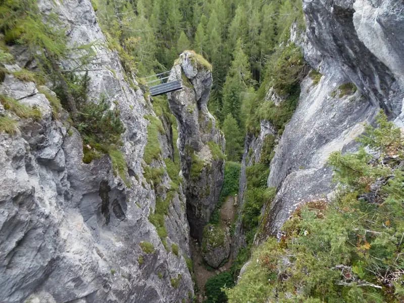
Once past the wall, you emerge onto a small terrace; the gear turns left for a few meters before heading back up vertically with another series of stirrups, interrupted only by a brief traverse. You then exit the wall onto a sturdy suspension bridge that spans the gorge below-the same one you crossed at the entrance. This bridge marks a break from the vertical progression and introduces a more horizontal, panoramic phase. From here onward, the equipment follows an equipped trail. You climb a few easy rock steps among the mountain pines until you reach the second suspension bridge.
After crossing the bridge, a short section of trail, initially equipped, leads to the third bridge. Following another brief stretch of path, you finally arrive at the Bivacco Pian delle Stelle, the endpoint of the ferrata. The time on the equipped route is about 30 minutes from the attack point (45 minutes total from the car park). The itinerary alternates short bursts of verticality with walking sections in a balanced way, offering varied but never exhausting progression.
Descent
The descent can be done entirely by retracing the ascent route. Alternatively, after crossing the first two bridges and near the third (which would mark the start of the descent into the gorge), you can follow a track that bypasses the gorge itself. This alternative route first descends via a ladder, then joins, via a trail, the approach path used on the way up, allowing you to return to the parking area. This loop takes about 30 minutes from the bivouac, for a total of about 1 hour and 15 minutes. The loop option, using a ridge or mid-slope trail, avoids repeating the bridges and rounds out the experience with a different perspective on the route.
Useful Notes
This easy ferrata at Sass de Rocia is the simplest equipped route in the area of the Marmolada sub-group, home to historic routes like the Ferrata Eterna, those of Punta Penia, Col Ombert, and Colac. Continuing toward Passo Falzarego, you'll find two other beginner-friendly ferratas: the easy Ra Gusela and the slightly more challenging Ferrata all'Averau. Heading south instead, toward the Civetta, the offerings become more demanding with routes like the Fiamme Gialle, the Tissi, the Alleghesi, or the long Ferrata Costantini alla Moiazza. Its geographic position makes it an excellent introductory training ground before tackling the great Dolomite classics.
Track and weather
Plan the route
Preview the GPX track from the backend, download it for your GPS device, open parking directions, and check a short forecast before leaving.
Images
FAQ
What level of commitment does this via ferrata require?
ferrata.faqAnswers.commitment
How much elevation gain should I plan for?
The listed ferrata elevation gain is 100 m. Also consider approach, return and maximum altitude, because they can matter more than the equipped section alone.
Where is the route located?
Ferrata Sass de Rocia is located in Sass de Rocia, Belluno, Italy. Before leaving, check parking, access and current local conditions.
When is the best time to climb it?
The best season depends on altitude, aspect and lingering snow. Avoid storms, wet rock and uncertain conditions; start early and keep a margin for the return.
Gear and safety planning
Use the technical data on this page to plan equipment, timing and offline navigation. For a general checklist, read the equipment guide before opening the route in the app.
Video
Watch the route
Useful YouTube videos for getting a real feel for the route before you go.
Logbook
Route condition reports
Recent community notes about closures, snow, equipment damage, trail issues and current conditions.
Community
Reviews, check-ins and photos
-
0 reviews
0
0 climbers
0
Shared by the community
Community photos
Recent images uploaded by Sferrati members.
No community photos yet
Open this route in the app to add the first photo.
Reviews
Recent impressions from climbers who know the route.
No reviews yet
Be the first to review this via ferrata from the app.
Continue in the app
Track the climb, save maps offline, and sync this route to your personal profile.
Use the app to climb
Offline maps, tracking, saves, and profile sync.
Scan the code before leaving, install the app, and keep your route data ready when reception fades.
