
Technical data
- Difficulty
- Facile
- Status
- aperta
- Distance
- 16,3 km
- Total duration
- 6 h
- Approach
- 1 h 30 min
- Ferrata time
- 1 h 30 min
- Elevation gain
- 981 m
- Max altitude
- 2300 m
Route planning
How to plan Ferrata Terza Cengia Pomagagnon
Ferrata Terza Cengia Pomagagnon is in Pomagagnon, Belluno, Italy and is rated Facile. Available route data lists about 6 h total time, 16,3 km of distance, 981 m of elevation gain.
For day planning, consider an approach of about 90 min, about 90 min on the cable, a maximum altitude near 2300 m. Reported route features include: Itinerario lungo.
The page includes a parking or driving-directions reference. A GPX track is available to review and download.
As with every via ferrata, evaluate season, lingering snow, storms, crowds and equipment condition. Page last updated on 7/4/2026.
Features
Description
Overview
The Ferrata della Terza Cengia del Pomagagnon, also known as the Sentiero Attrezzato Zumeles, is an easy-grade route starting from Cortina d'Ampezzo. The trail follows a long, airy ledge carved into the steep southern slopes of the Pomagagnon massif, leading to the summit of Punta Erbin. The route requires no specific climbing skills, but is characterized by constant and pronounced exposure for most of its length. This is a demanding hike in terms of elevation gain and duration, amply rewarded by breathtaking 360-degree views of Cortina's major Dolomite peaks.
The route unfolds entirely along a horizontal ledge, a natural groove etched into the rock face. Progression is therefore predominantly lateral, with a steady pace and limited elevation gain along the via ferrata itself. The character of the hike is essentially psychological and scenic: the exposure is continuous, and the path winds suspended above Val Padeon, offering a unique aerial perspective over the Ampezzo basin.
Approach
The starting point is the Istituto Putti parking lot, located just above Cortina d'Ampezzo and reachable via a paved road with switchbacks branching off from State Road 51. From the parking lot, head northeast toward the imposing silhouette of the Pomagagnon. Several trails climb through the woods and all converge, after a short stretch, onto the wide trail 211 (a bike path). Continue keeping left for less than a kilometer until you reach the junction with trail 202. Take this trail, turning right and proceeding with a steady climb, ignoring the later turnoff for trail 218. Continue straight until you reach the obvious descent gully of the Ferrata Strobel (which descends from Punta Fiames) on your left. At this point, instead keep right, descend slightly, then climb back up to the left following signs toward a wide diagonal ledge that is clearly visible. The start of the via ferrata, marked as Sentiero Attrezzato Zumeles, is reached in about 1 hour and 30 minutes from the parking lot.
The approach runs through a wooded slope, with a constant climb that physically prepares you for the route. The terrain changes dramatically upon exiting the woods, when you emerge at the base of the great limestone wall of the Pomagagnon. Here the trail becomes rockier, and the wide, oblique ledge that will guide the entire ascent becomes clearly visible.
Via Ferrata
The route unfolds entirely along the distinctive ledge that gives the itinerary its name. It is advisable to wear your helmet already in the final meters of the approach due to the possible fall of stones from the overhanging walls of the Pomagagnon. The start of the ledge is steep but unroped, with no particular technical difficulties. You then encounter the first section of steel cable, after which the ledge progressively narrows and becomes more exposed. The climb proceeds alternating between equipped sections and unprotected stretches, some of which are very airy and have a sometimes gravelly, unstable surface. Progression therefore requires a steady foot and no fear of heights, though actual climbing is never necessary.
The ledge is carved into compact limestone but is often covered with debris. The pace is continuous, with no mandatory stops, but demands constant attention due to the combination of exposure and occasionally unstable terrain. The experience is that of a suspended walk, with a sheer wall to your left and the void of the valley to your right.
You overcome a second section of cable that goes around a corner and climbs decisively to the left. After rounding another rocky spur, you tackle a short descending passage that leads to a comfortable rest point. From here begins the steepest and most demanding section of the ledge. You climb diagonally on a very exposed passage, where the steel cable of the final stretch proves useful not only for the exposure but also to overcome the gradient on unstable ground. After rounding a corner to the left, you enjoy a magnificent view of the Sorapiss and Faloria. Even in this part, protections are present only at the most critical points.
This central section changes the rhythm of the route, introducing a steeper gradient and more physical progression, though still on walking terrain. The ledge remains wide, but the incline and lateral exposure heighten the sense of commitment.
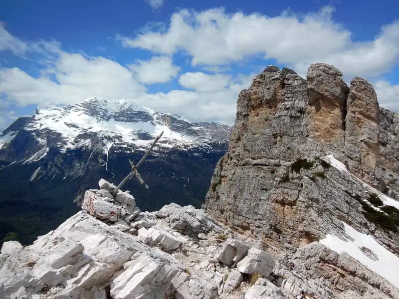
Finally, you reach the last equipped section, which leads to the col between Punta Erbin and Croda di Cestellis. You overcome some easy rock steps and a short equipped trail to reach the col at 2250 meters (about 1 hour and 30 minutes from the start of the ferrata; 3 hours total). From the col, the view opens onto the opposite side toward the Cristallo and the Sexten Dolomites. With a few minutes of easy scrambling on rocks, you conquer the summit cross of Punta Erbin (2301 m), reachable in 15 minutes round trip from the col, for a total of about 3 hours and 15 minutes from the start of the hike. The panorama of the Tofane towering over Cortina is a worthy reward for the effort.
Arriving at the col marks the transition from the airy environment of the ledge to the more open crest. The short final detour to the summit is a classic example of easy scrambling on dolomite blocks, completing the route with a privileged panoramic viewpoint.
Descent
From the end of the ferrata, descend toward Val Padeon. The first section consists of a steep traverse descent on rock, which requires attention and can become tricky if the rock is wet. After overcoming a few short rock steps, the difficulties diminish, and you continue on a trail until reaching Forcella Zumeles (2079 m) in about 45 minutes. Here, trails 204 and 205 intersect. Take the right fork toward Rifugio Mietres, thus returning to the Cortina side of the Pomagagnon. The trail, sometimes stabilized with wooden walkways, descends steadily. Upon reaching a junction between trail 211 and 204, it is recommended to take trail 211 to the right, which descends more gently and directly, ignoring secondary deviations, until it leads back to the Istituto Putti parking lot. The descent from Forcella Zumeles takes about 2 hours and 15 minutes, for a total of about 3 hours from the end of the ferrata and 6 hours total for the entire loop.
The initial descent toward Val Padeon is technical and requires concentration, marking a clear transition from the horizontal progression of the ledge to a demanding up-and-down on bare rock. Once Forcella Zumeles is reached, the pace becomes that of a long, steady descent on a mountain trail, which first crosses debris fields and then dense conifer forests.
Useful Notes
The Ferrata della Terza Cengia del Pomagagnon is a technically easy but psychologically demanding route due to the continuous exposure. Progression occurs entirely on the ledge, with no actual climbing passages. It is essential to pay maximum attention in some points where the ledge narrows considerably and is unprotected, with a precipice to the right. The first section of the descent toward Forcella Zumeles should also not be underestimated, especially with wet rock. In bad weather, the steepest section of the ledge in the second half of the route can become problematic. The route's equipment was largely renewed in 2017. For maps, dedicated sheets for the Sexten Dolomites or Cortina and the Ampezzo Dolomites are recommended.
The experience is dominated by constant exposure and the need for a sure step on sometimes loose terrain. This is a via ferrata where the psychological component clearly prevails over the technical one, offering a grand, sweeping experience in a majestic environment.
The route lends itself to being logically combined with the nearby Ferrata Strobel to Punta Fiames, as its descent gully intersects the approach trail to the Terza Cengia. The Cortina area offers numerous other via ferrata alternatives, such as the Ferrata Bovero on Col Rosa, the Sentiero Attrezzato alle Cascate di Fanes, the Ferrata Renè de Pol on the Cristallo, or the various routes on the Tofane (Formenton, Aglio, Olivieri) and the challenging Ferrata Sci Club 18 on Monte Faloria.
Track and weather
Plan the route
Preview the GPX track from the backend, download it for your GPS device, open parking directions, and check a short forecast before leaving.
Images
FAQ
What level of commitment does this via ferrata require?
ferrata.faqAnswers.commitment
How much elevation gain should I plan for?
The listed ferrata elevation gain is 981 m. Also consider approach, return and maximum altitude, because they can matter more than the equipped section alone.
Where is the route located?
Ferrata Terza Cengia Pomagagnon is located in Pomagagnon, Belluno, Italy. Before leaving, check parking, access and current local conditions.
When is the best time to climb it?
The best season depends on altitude, aspect and lingering snow. Avoid storms, wet rock and uncertain conditions; start early and keep a margin for the return.
Gear and safety planning
Use the technical data on this page to plan equipment, timing and offline navigation. For a general checklist, read the equipment guide before opening the route in the app.
Video
Watch the route
Useful YouTube videos for getting a real feel for the route before you go.
Logbook
Route condition reports
Recent community notes about closures, snow, equipment damage, trail issues and current conditions.
Community
Reviews, check-ins and photos
-
0 reviews
0
0 climbers
0
Shared by the community
Community photos
Recent images uploaded by Sferrati members.
No community photos yet
Open this route in the app to add the first photo.
Reviews
Recent impressions from climbers who know the route.
No reviews yet
Be the first to review this via ferrata from the app.
Continue in the app
Track the climb, save maps offline, and sync this route to your personal profile.
Use the app to climb
Offline maps, tracking, saves, and profile sync.
Scan the code before leaving, install the app, and keep your route data ready when reception fades.
