
Technical data
- Difficulty
- Facile
- Status
- aperta
- Distance
- 9,1 km
- Total duration
- 5 h
- Approach
- 2 h 30 min
- Ferrata time
- 30 min
- Elevation gain
- 100 m
- Max altitude
- 1207 m
Route planning
How to plan Sentiero Attrezzato degli Eroi
Sentiero Attrezzato degli Eroi is in Monte Peurna, Belluno, Italy and is rated Facile. Available route data lists about 5 h total time, 9,1 km of distance, 100 m of elevation gain.
For day planning, consider an approach of about 150 min, about 30 min on the cable, a maximum altitude near 1207 m. Reported route features include: Interesse Storico.
The page includes a parking or driving-directions reference. A GPX track is available to review and download.
As with every via ferrata, evaluate season, lingering snow, storms, crowds and equipment condition. Page last updated on 7/4/2026.
Features
Description
Overview
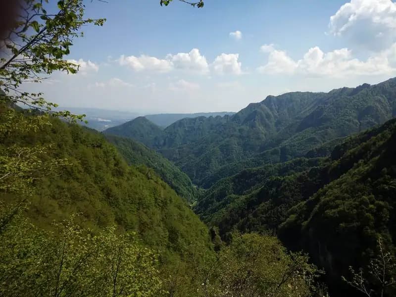
The Sentiero Attrezzato degli Eroi, which runs along the southern slope of Monte Peurna in Val Schievenin, combines historical significance with a distinctive technical character. The short via ferrata sections are of low difficulty, but the real challenge of the route lies in the long, continuous unsecured traverses, where the uneven and crumbly terrain demands a sure foot and constant concentration. Poor maintenance often makes the trail faint, forcing you to read the ground carefully and rely on solid navigation skills, in an environment that alternates between sparse woods and steep grassy slopes.
Approach
Access to Val Schievenin, in the province of Belluno, is from the Piave Valley. From Quero, turn east following signs for Schievenin. After passing through the village, follow the narrow paved road that penetrates the valley to a large parking area (515 m), beyond which traffic is prohibited. Caution is advised due to some rough sections and washouts, which are not recommended for very low-clearance vehicles. The exact location of the parking area is marked on major digital maps.
From the parking area, take the road closed to traffic, heading north, initially coinciding with the dirt track of trail 848 toward Forcella Bassa. After about 15 minutes of walking, at a wide curve, it is essential to spot a small sign indicating a faint path (not marked with a trail marker) that branches off sharply to the left into the woods. Trail 848 continues its ascent into the wild Valle dell'Inferno. This approach section, whose condition dates to 2017, is poorly maintained: the trail is faint in places, obstructed by fallen trees, and runs along mid-slope hillsides with loose soil and exposure on the left side. The pace is therefore uneven, alternating between stretches of brisk walking and more careful, deliberate steps. Reaching Forcella Bassa (1044 m) about one hour from the junction, keep left to join the wider Sentiero degli Eroi, following signs for the Alta Via 8. The route now turns decisively south, maintaining a constant traverse on the eastern slope of Monte Peurna. The terrain becomes predominantly grassy and earthy, treacherously slippery, and the trail proceeds for long stretches completely without protection, requiring balance and a steady step. After rounding the compact east face of the mountain, you finally reach the start of the first equipped section, on the southeastern slope, after about 1 hour and 15 minutes from the pass (for a total of about 2 hours and 30 minutes from the parking area).
Via Ferrata
The equipped route begins with a ridge passage, where the steel cable runs to the right of the hiker, offering a first panoramic view of the valley. You then tackle a short but exposed protected descent that leads to a wide, easy ledge, also equipped with a cable. The route then proceeds south along the trail before encountering the second and final via ferrata section. This is characterized by a very steep ascent on particularly slippery ground (polished rock and dirt), made safe only by the presence of the cable, which requires active and continuous use. Beyond this point, all metal fixtures end, marking the conclusion of the actual equipped section of the Sentiero degli Eroi. This via ferrata segment, though technically simple, has a discontinuous character and takes about 30 minutes, for a total time from the start of the hike of about 3 hours.
Descent
From the end of the equipment, continue with a gentle descent until you intersect trail 843. Keep left and, after a short stretch, turn left again following the sign for trail 839, which descends directly and steeply toward Schievenin, initially through wooded terrain and then across meadows. The trail emerges onto the paved road used on the ascent, but at a lower elevation than the parking area. To complete the loop, you must walk back up the paved road for about a kilometer and a half to the starting point. The descent takes about 2 hours, for a total hike time of about 5 hours.
Useful Notes
This route partly retraces the sites of the battles of the Great War. The technical difficulties in the equipped sections are modest; the real attention must be focused on the numerous and prolonged passages on unprotected trail, with unstable, potentially slippery, and at times exposed terrain. The itinerary, little traveled and maintained, may present sections of faint trail, fallen trees, as well as areas with tall, overgrown vegetation. Long pants and trekking poles are therefore strongly recommended for greater stability, to protect against vegetation, and to reduce the load on the lower limbs during the long traverses.
Track and weather
Plan the route
Preview the GPX track from the backend, download it for your GPS device, open parking directions, and check a short forecast before leaving.
Images
FAQ
What level of commitment does this via ferrata require?
ferrata.faqAnswers.commitment
How much elevation gain should I plan for?
The listed ferrata elevation gain is 100 m. Also consider approach, return and maximum altitude, because they can matter more than the equipped section alone.
Where is the route located?
Sentiero Attrezzato degli Eroi is located in Monte Peurna, Belluno, Italy. Before leaving, check parking, access and current local conditions.
When is the best time to climb it?
The best season depends on altitude, aspect and lingering snow. Avoid storms, wet rock and uncertain conditions; start early and keep a margin for the return.
Gear and safety planning
Use the technical data on this page to plan equipment, timing and offline navigation. For a general checklist, read the equipment guide before opening the route in the app.
Video
Watch the route
Useful YouTube videos for getting a real feel for the route before you go.
Logbook
Route condition reports
Recent community notes about closures, snow, equipment damage, trail issues and current conditions.
Community
Reviews, check-ins and photos
-
0 reviews
5
4 climbers
0
Shared by the community
Community photos
Recent images uploaded by Sferrati members.
No community photos yet
Open this route in the app to add the first photo.
Reviews
Recent impressions from climbers who know the route.
No reviews yet
Be the first to review this via ferrata from the app.
Continue in the app
Track the climb, save maps offline, and sync this route to your personal profile.
Use the app to climb
Offline maps, tracking, saves, and profile sync.
Scan the code before leaving, install the app, and keep your route data ready when reception fades.
