
Technical data
- Difficulty
- Facile
- Status
- aperta
- Distance
- 13,4 km
- Total duration
- 4 h 30 min
- Approach
- 1 h 30 min
- Ferrata time
- 1 h
- Elevation gain
- 256 m
- Max altitude
- 2622 m
Route planning
How to plan Sentiero Attrezzato del Gronton
Sentiero Attrezzato del Gronton is in Cima Bocche, Trento, Italy and is rated Facile. Available route data lists about 4 h 30 min total time, 13,4 km of distance, 256 m of elevation gain.
For day planning, consider an approach of about 90 min, about 60 min on the cable, a maximum altitude near 2622 m. Reported route features include: Ponti sospesi, Funivia all'andata, Funivia al ritorno, Interesse Storico.
The page includes a parking or driving-directions reference. A GPX track is not available yet, so bring an alternative map source.
As with every via ferrata, evaluate season, lingering snow, storms, crowds and equipment condition. Page last updated on 7/4/2026.
Features
Description
Overview
The Sentiero Attrezzato del Gronton is a high-altitude route accessible without specific climbing skills, though safety depends on solid mountain familiarity due to constant exposure. This loop trail starts from Passo Lusia, follows the Gronton ridge, reaches Forcella delle Bocche, and descends past the scenic Laghi di Lusia. It's a medium-length hike where historical interest blends with sweeping panoramas.
Approach
The starting point is Passo Lusia (2055 m), reachable by car from Moena in the Val di Fassa. Driving along the Passo San Pellegrino state road, shortly after Moena you'll spot the ski lifts of the Lusia resort. After crossing the overpass over the slopes, a gravel road on the right climbs for a few kilometers to the Rifugio al Passo Lusia, the base for this itinerary.
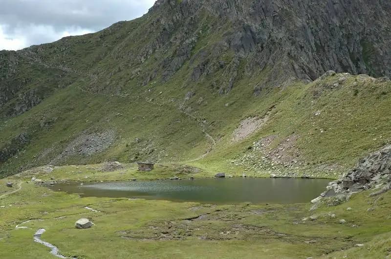
From the refuge, take the CAI trail 633 heading south toward Cima Bocche. The path, with no technical difficulty, rises at a steady gradient through wide pastures to Sella Lusia at 2360 meters. From this saddle, you get an excellent view of the entire route: the Gronton crest to the left, Cima Bocche ahead, and the Laghi di Lusia below, which you'll skirt on the descent. From the saddle, the trail continues with a slight descent along the hillside to the Bivacco Redolf (2335 m). At this junction, leave trail 633 (which will be your return route) and bear left onto CAI 634, which leads to the start of the via ferrata at Forcella Cajerin (2365 m). The approach from the refuge takes about 1 hour and 30 minutes of easy walking at a steady but not strenuous pace.
Via Ferrata
From Forcella Cajerin, the Sentiero Attrezzato del Gronton begins, following an Austrian defensive line from World War I. The route runs mostly just below the ridge crest, with continuous protection from steel cables on the more exposed sections. After a short initial stretch, you tackle an exposed ledge with the cable on your right, followed by a series of passages over large boulders alternating with stepped sections-clear remnants of military positions.
The rock, typical Dolomite, is compact and blocky, making for secure progress. The pace of the route is uneven: near-horizontal traverses on ledges alternate with short vertical rises and ridge passages, maintaining constant but never extreme exposure. After another equipped ledge and a distinctive suspended footbridge, you reach a clearly visible saddle. Cross it and lose a bit of elevation along another exposed but safe ledge. The climb resumes at a moderate gradient until you hit the main ridge, where you can look back at the route you've covered and the Laghi di Lusia below. The most spectacular and photogenic part of the hike is the ridge walk itself, which includes an airy passage around a rocky spur, offering a sense of great freedom in a panoramic setting.
After a final ridge section, you arrive at a marked junction on a boulder: to the right, descend toward Forcella delle Bocche; to the left, a side trail climbs to the summit of Gronton in about an hour round trip, an option that reveals more wartime relics. Continuing toward the saddle, just before reaching it, a trail on the left branches off to the summit of Cima Bocche (2745 m), a recommended ascent for the views (about 1 hour round trip). You then arrive at Forcella delle Bocche (2543 m) after roughly 1 hour on the via ferrata and 2 hours and 30 minutes total from the refuge.
Descent
From Forcella delle Bocche, take CAI trail 633 for the return. The path descends decisively into the valley that holds the scenic Laghi di Lusia, a glacial landscape where it's not uncommon to encounter herds of wild horses. The descent flows at a smoother, more continuous pace on a well-defined trail that skirts the lakes, then climbs with moderate gradient back to Sella Lusia and from there to the Rifugio al Passo Lusia. The descent from the saddle to the refuge takes about 2 hours, for a total of 4 hours and 30 minutes for the base loop. Adding the ascent of Cima Bocche brings the time to roughly 5 hours and 30 minutes.
Useful Notes
The Sentiero Attrezzato del Gronton is technically accessible, with no true climbing passages. Its appeal lies in the blend of historical interest, continuous views, and the distinctive atmosphere of the Laghi di Lusia. It's generally less crowded than other via ferratas in the area. The route's character is more panoramic and historical than technical, though the pace is set by a series of exposed sections that demand constant attention. The only real difficulty is the significant exposure, constant throughout the route, which requires an absolute absence of vertigo. For planning, it's advisable to have detailed maps of the area, such as those dedicated to the Val di Fassa.
Track and weather
Plan the route
Preview the GPX track from the backend, download it for your GPS device, open parking directions, and check a short forecast before leaving.
GPX track unavailable
This route does not include a downloadable track yet.
Images
FAQ
What level of commitment does this via ferrata require?
ferrata.faqAnswers.commitment
How much elevation gain should I plan for?
The listed ferrata elevation gain is 256 m. Also consider approach, return and maximum altitude, because they can matter more than the equipped section alone.
Where is the route located?
Sentiero Attrezzato del Gronton is located in Cima Bocche, Trento, Italy. Before leaving, check parking, access and current local conditions.
When is the best time to climb it?
The best season depends on altitude, aspect and lingering snow. Avoid storms, wet rock and uncertain conditions; start early and keep a margin for the return.
Gear and safety planning
Use the technical data on this page to plan equipment, timing and offline navigation. For a general checklist, read the equipment guide before opening the route in the app.
Video
Watch the route
Useful YouTube videos for getting a real feel for the route before you go.
Logbook
Route condition reports
Recent community notes about closures, snow, equipment damage, trail issues and current conditions.
Community
Reviews, check-ins and photos
-
0 reviews
1
1 climbers
0
Shared by the community
Community photos
Recent images uploaded by Sferrati members.
No community photos yet
Open this route in the app to add the first photo.
Reviews
Recent impressions from climbers who know the route.
No reviews yet
Be the first to review this via ferrata from the app.
Continue in the app
Track the climb, save maps offline, and sync this route to your personal profile.
Use the app to climb
Offline maps, tracking, saves, and profile sync.
Scan the code before leaving, install the app, and keep your route data ready when reception fades.
