
Technical data
- Difficulty
- Facile
- Status
- aperta
- Distance
- 17,6 km
- Total duration
- 8 h 30 min
- Approach
- 2 h 45 min
- Ferrata time
- 1 h
- Elevation gain
- 1397 m
- Max altitude
- 2847 m
Route planning
How to plan Ferrata Gabrielli a Cima d'Asta
Ferrata Gabrielli a Cima d'Asta is in Cima d'Asta, Trento, Italy and is rated Facile. Available route data lists about 8 h 30 min total time, 17,6 km of distance, 1397 m of elevation gain.
For day planning, consider an approach of about 165 min, about 60 min on the cable, a maximum altitude near 2847 m. Reported route features include: Scale, Itinerario lungo.
The page includes a parking or driving-directions reference. A GPX track is available to review and download.
As with every via ferrata, evaluate season, lingering snow, storms, crowds and equipment condition. Page last updated on 7/4/2026.
Features
Description
Overview
The Ferrata Gabrielli offers an ideal introduction to via ferrata mountaineering, set within a captivating circular route that culminates in the ascent of Cima d'Asta, the highest peak in the entire Lagorai range. The itinerary stands out for its length and significant elevation gain, while the actual equipped section is rated easy difficulty, suitable even for beginners. The hike delivers vast panoramas and a complete alpine experience, blending technical accessibility with the satisfaction of reaching a majestic summit.
Approach
The starting point is the parking area at Malga Sorgazza (1451 m), in the Trentino Valsugana region. From Trento, follow the direction for Padua, pass through Caldonazzo and Levico Terme, and after about 50 km, turn left for Pieve Tesino. From the village, take via Marchetto and, at a hairpin turn, continue straight following signs for Malga Sorgazza and Cima d'Asta, all the way to the final parking lot.
The approach to the via ferrata is quite long and involved. From the parking area, ascend along the forest road of trail CAI 327, passing an artificial lake and the Sorgazza War Cemetery. Continue, ignoring the turnoffs for Monte Coston (CAI 386, to the right) and Buse Todesche (CAI 360, to the left), heading toward the lower station of the cableway for Rifugio Brentari. At the next junction (1650 m, about 40 minutes from the start), take CAI 380 to the left, which climbs with increasing steepness and numerous switchbacks toward Forcella Magna. After about 1 hour and 15 minutes on this path, you reach the pass, where you keep right onto trail CAI 326 in the direction of Rifugio Brentari and the via ferrata. After about a quarter of an hour, you encounter another junction: leave the 326, which continues straight for the refuge, and turn left uphill along a mule track, following signs for the Ferrata Giulio Gabrielli (CAI 375). The trail, free of difficulty, traverses broadly around the slope below Punta Socede (2345 m), then descends gently toward Forcella Tellina (2249 m), from where the via ferrata wall begins to come into view. Reaching the pass, keep to the left side of the mountain following the white-red markings, and shortly you arrive at the start, marked by a distinctive red sign and a striking bright yellow rock face (2260 m). The total approach time from the parking area is about 2 hours and 45 minutes.
Via Ferrata
The Ferrata Gabrielli begins by ascending a first series of rocky steps to the right, then swings decisively left to tackle several rocky ledges. These are a bit exposed but present no particular technical difficulty. Continue along a simple rocky ledge, where the first equipped sections end. This is followed by a short trail interlude connecting the two sections of the route.
The second section of the via ferrata is steeper than the first. It starts with a wall equipped with a series of solid metal stirrups. Climb a first stretch, cross a short terrace to the right to tackle a second vertical section, then cross back to the left for the final ascent, again on stirrups.
Once the equipped section is finished, continue along a high-altitude trail toward Cima di Col Verde (not marked), reachable after a couple of exposed and briefly equipped sections. From here, the view opens up to the imposing silhouette of Cima d'Asta. From Cima Verde, descend over a marked scree slope toward Passo di Socede (2518 m). The time from the start of the via ferrata to the pass is about 1 hour (for a total of about 4 hours from the parking area).
From Passo Socede, there are two options to reach the summit:
- Keeping right on CAI 375, ascend the Canalone dei Bassanesi (marked as an Alpine Trail) with passages of grade I+. Climbing the steep gully following the red blazes, you reach Bocchetta del Canalon (2664 m, 45 minutes from the pass). From here, ascending the ridge to the right with passages still at grade I+ and following the blazes, you arrive at Cima d'Asta (2847 m, 45 minutes from the notch). This variant passes by the Bivacco Cavinato.
- Keeping right on CAI 375, first reach Rifugio Brentari (2473 m), then follow trail CAI 364 to ascend Cima d'Asta via the normal route (1 hour and 30 minutes from Passo Socede).
Descent
From the summit of Cima d'Asta, descend along the normal route leading to trail CAI 364. Keeping right at mid-slope in the direction of Forzelletta (reachable via a short equipped climb), then descend to Rifugio Brentari (about 1 hour and 15 minutes from the summit).
From the refuge, continue descending, skirting the beautiful Lago di Cima d'Asta, always on trail CAI 327. Descend over slabs, ignoring the junctions to the right for the 327B and later for Forcella Magna, continuing the descent until you meet the outward-bound junction near the cableway. From here, retrace the approach trail back to the parking area at Malga Sorgazza. The total time for the entire loop is about 8 hours and 30 minutes.
Useful Notes
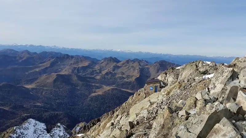
The Ferrata Giulio Gabrielli is technically easy, with no points of particular physical or technical challenge. The hike as a whole is highly rewarding, and the moderate difficulty rating is solely due to the Canalone dei Bassanesi variant, which features free-climbing passages of a higher grade than the rest of the route. The view from the summit of Cima d'Asta amply repays the effort, spanning 360 degrees from the Piccole Dolomiti and Pale di San Martino to the glaciers on the Austrian border and the Dolomiti di Brenta.
For maps, a detailed map of the Lagorai Group and Cima d'Asta is recommended. The Lagorai area is not particularly rich in via ferratas; for similar experiences, you can head toward Bassano del Grappa (Ferrata Sass Brusai, Ferrata Guzzella, Sentiero degli Eroi) or toward Trento (Sentiero Attrezzato Chiesa in Val Scura, Sentiero Attrezzato Bertotti). Another good option nearby is the Ferrata Val di Scala, reachable by heading toward Fiera di Primiero.
Track and weather
Plan the route
Preview the GPX track from the backend, download it for your GPS device, open parking directions, and check a short forecast before leaving.
Images
FAQ
What level of commitment does this via ferrata require?
ferrata.faqAnswers.commitment
How much elevation gain should I plan for?
The listed ferrata elevation gain is 1397 m. Also consider approach, return and maximum altitude, because they can matter more than the equipped section alone.
Where is the route located?
Ferrata Gabrielli a Cima d'Asta is located in Cima d'Asta, Trento, Italy. Before leaving, check parking, access and current local conditions.
When is the best time to climb it?
The best season depends on altitude, aspect and lingering snow. Avoid storms, wet rock and uncertain conditions; start early and keep a margin for the return.
Gear and safety planning
Use the technical data on this page to plan equipment, timing and offline navigation. For a general checklist, read the equipment guide before opening the route in the app.
Video
Watch the route
Useful YouTube videos for getting a real feel for the route before you go.
Logbook
Route condition reports
Recent community notes about closures, snow, equipment damage, trail issues and current conditions.
Community
Reviews, check-ins and photos
-
0 reviews
0
0 climbers
0
Shared by the community
Community photos
Recent images uploaded by Sferrati members.
No community photos yet
Open this route in the app to add the first photo.
Reviews
Recent impressions from climbers who know the route.
No reviews yet
Be the first to review this via ferrata from the app.
Continue in the app
Track the climb, save maps offline, and sync this route to your personal profile.
Use the app to climb
Offline maps, tracking, saves, and profile sync.
Scan the code before leaving, install the app, and keep your route data ready when reception fades.
