
Sentiero Attrezzato delle Scalette
Catinaccio · Trento · Italy
Technical data
- Difficulty
- Moderatamente Difficile
- Status
- aperta
- Distance
- 16 km
- Total duration
- 5 h 30 min
- Approach
- 1 h
- Ferrata time
- 1 h
- Elevation gain
- 150 m
- Max altitude
- 2720 m
Route planning
How to plan Sentiero Attrezzato delle Scalette
Sentiero Attrezzato delle Scalette is in Catinaccio, Trento, Italy and is rated Moderatamente Difficile. Available route data lists about 5 h 30 min total time, 16 km of distance, 150 m of elevation gain.
For day planning, consider an approach of about 60 min, about 60 min on the cable, a maximum altitude near 2720 m. Reported route features include: Scale, Itinerario lungo.
The page includes a parking or driving-directions reference. A GPX track is not available yet, so bring an alternative map source.
As with every via ferrata, evaluate season, lingering snow, storms, crowds and equipment condition. Page last updated on 7/4/2026.
Features
Description
Overview
The Sentiero Attrezzato delle Scalette is the fastest route from Rifugio Gardeccia into the wild, remote valleys of the Larsec and Laussa, deep in the Dolomitic massif of the Catinaccio. It is an ideal itinerary for a first taste of equipped trails, as it requires no particular technical skills. The main concern must be the weather: the upper valleys, open and exposed, can turn into hostile environments if conditions suddenly worsen.
Approach
The route begins at Rifugio Gardeccia (1949 m), in the Val del Vajolet, a side valley of the Val di Fassa in the province of Trento. The valley is closed to private traffic. To reach the hut, you can take the cable car from Vigo di Fassa to Rifugio Ciampedie, followed by a pleasant 45-minute walk; the shuttle bus from Pozza di Fassa (about 20 minutes-check times and stop with the tourist office); or the cable car from Pera di Fassa with a subsequent stretch on foot.
From here, follow trail CAI 583, which traverses beneath the towering walls of the Larsec. The path heads east, skirting large rock bastions before turning north and beginning a steeper climb. After about an hour of walking, a signpost indicates bearing left onto a new track that bypasses a section of trail damaged by a landslide.
Via Ferrata
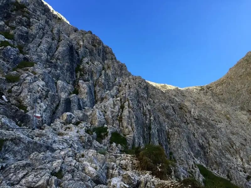
At this junction, the actual Sentiero Attrezzato delle Scalette begins, plunging into a steep gully aimed directly at Passo delle Scalette. The terrain is characterized by solid, compact rock, typical of the Dolomites. The first equipped meters are tackled along an exposed ledge; once past it, a series of metal stirrups facilitate a short traverse. The rhythm is uneven: equipped sections alternate with stretches of steep trail without protection, until a second sector with cable and stirrups. This passage, on the left side of the gully, requires climbing up some small rock steps. A short vertical step is then overcome thanks to new metal rungs, concluding with a final steep trail section-technically easy but physically demanding-that leads to Passo delle Scalette (2348 m). The time for the via ferrata itself is about one hour, for a total of 2 hours from Rifugio Gardeccia. The route is predominantly vertical, with moderate exposure that offers sweeping views over the Val del Vajolet.
Descent
From Passo delle Scalette, several options exist for the return. The most popular involves crossing the desolate Valle del Larsec to Passo Pope (2720 m), followed by the descent via the steep Sentiero Don Guido to Rifugio Vajolet (2243 m) and the return to Val del Vajolet at Rifugio Gardeccia (about 5 hours and 30 minutes total). The second alternative, longer and more demanding, is to continue on CAI 583 through the austere Valle di Laussa to Passo di Laussa (2700 m). From here, you can descend to Rifugio d'Antermoia (2497 m) beside the glacial lake, or bear left for Passo Principe. From the hut, you can also reach Passo Principe by taking the Ferrata al Catinaccio d'Antermoia. From Passo Principe, descend into Valle del Vajolet back to the starting point (5h 30' without detours, up to 8h including the lake and ferrata). The third option, shorter but less scenic, is to return by the ascent route (about 3 hours and 30 minutes total). The upper valleys offer a high-altitude experience over scree terrain, with a steady pace but unstable footing.
Useful Notes
The Sentiero Attrezzato delle Scalette presents no significant technical obstacles, but it does require good physical fitness due to the overall elevation gain. Evaluating whether to continue the hike into the Larsec or Laussa valleys is crucial: these open environments, lacking shelter and traversed by easy but long exposed ledges, can become prohibitive in the event of a thunderstorm, making weather planning a fundamental part of preparation. For maps, dedicated sheets for the Sciliar, Catinaccio, and Latemar or Val di Fassa are recommended. The itinerary can be combined with other ferratas in the group, such as the Ferrata al Catinaccio d'Antermoia, the Ferrata Bepo de Medil (preferably on descent), or routes in the northern area like the Ferrata Laurenzi and the Ferrata Maximilian.
Track and weather
Plan the route
Preview the GPX track from the backend, download it for your GPS device, open parking directions, and check a short forecast before leaving.
GPX track unavailable
This route does not include a downloadable track yet.
Images
FAQ
What level of commitment does this via ferrata require?
ferrata.faqAnswers.commitment
How much elevation gain should I plan for?
The listed ferrata elevation gain is 150 m. Also consider approach, return and maximum altitude, because they can matter more than the equipped section alone.
Where is the route located?
Sentiero Attrezzato delle Scalette is located in Catinaccio, Trento, Italy. Before leaving, check parking, access and current local conditions.
When is the best time to climb it?
The best season depends on altitude, aspect and lingering snow. Avoid storms, wet rock and uncertain conditions; start early and keep a margin for the return.
Gear and safety planning
Use the technical data on this page to plan equipment, timing and offline navigation. For a general checklist, read the equipment guide before opening the route in the app.
Video
Watch the route
Useful YouTube videos for getting a real feel for the route before you go.
Logbook
Route condition reports
Recent community notes about closures, snow, equipment damage, trail issues and current conditions.
Community
Reviews, check-ins and photos
-
0 reviews
0
0 climbers
0
Shared by the community
Community photos
Recent images uploaded by Sferrati members.
No community photos yet
Open this route in the app to add the first photo.
Reviews
Recent impressions from climbers who know the route.
No reviews yet
Be the first to review this via ferrata from the app.
Continue in the app
Track the climb, save maps offline, and sync this route to your personal profile.
Use the app to climb
Offline maps, tracking, saves, and profile sync.
Scan the code before leaving, install the app, and keep your route data ready when reception fades.
